
Multi faceted dynamic storm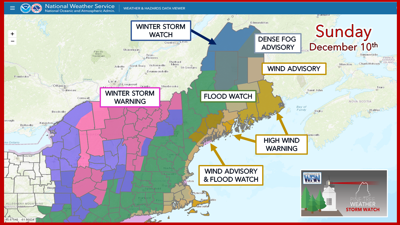 When the NWS watch & warning map looks like a holiday display, it's easy to figure out we're in for a burly event. As of Sunday morning, the main idea is together, but there is some wiggle room. With the combination of cold air knocking at the door and a strong sub-tropical low-level jet where frontal boundary is key to determine outcome in various areas. Results pending on region will be like a box of assorted chocolates, and for the area around the Quebec border, it may not be known what you get until you bite into one. Timing and intensity Sunday Noon to Monday 7 PM - Precipitation overspreads the region Sunday afternoon, becomes moderate with heavy spurs in spots overnight, and intensifies in areas as the low tracks through the state Monday. Outside of some developing snow showers in the mountains Monday night, it will be over by early evening. Heavy rain and potential for heavy snow The Weather Prediction Center has elevated central and southwestern areas to a slight risk of flash flooding. Frozen ground and heavy rain means runoff in areas that normally may not flood. If you are prone to basement flooding, it's fair bet that will happen here.  The heaviest rainfall is likely on the east side of the front. Central areas (Augusta, Waterville, Bangor) on up into Millinocket could be on the high end of rain amounts in the 3-4" range with some isolated areas may hit 5-6". Expect urban street flooding where storm drains clog, ponding on roadways and highways for both morning and evening commutes, some road flooding, and perhaps a few washouts. There will be snowmelt over the interior, which may add an inch or two of liquid from runoff that will try to find a way to escape. 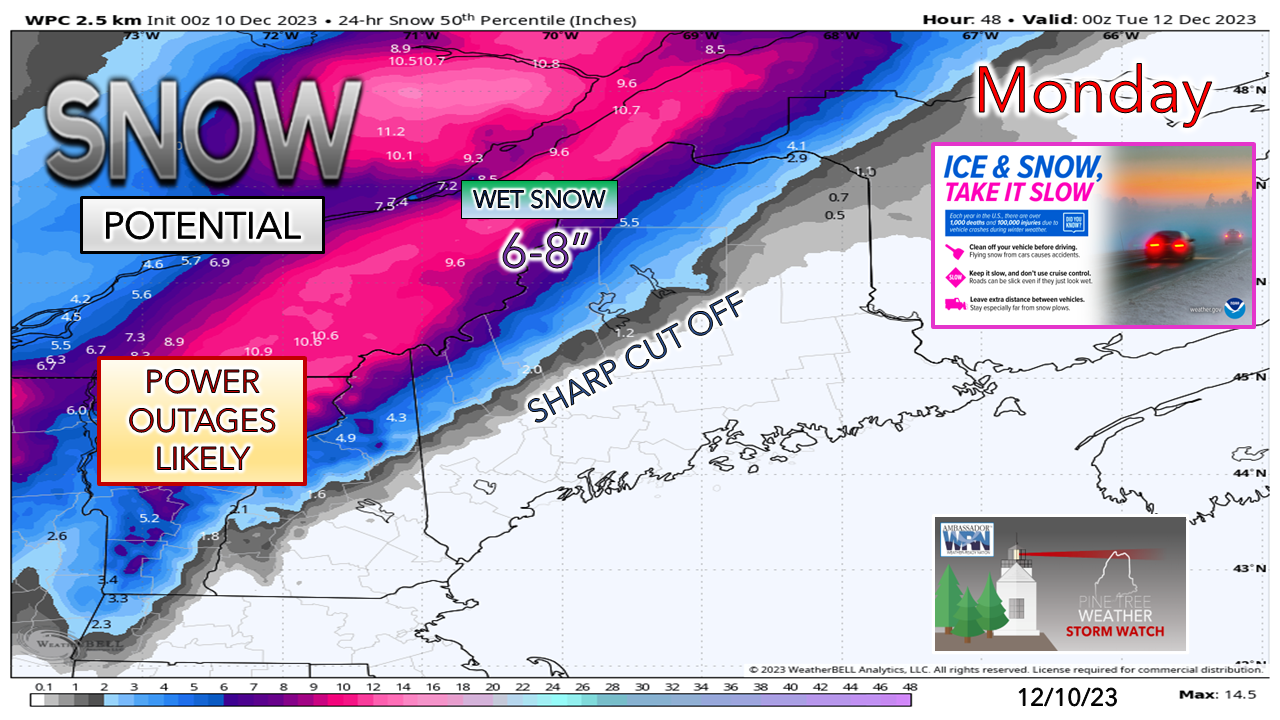 Figuring snowfall with this storm is the hardest part of the forecast. It all depends on the timing of the arrival of dynamic cooling aloft. If it comes sooner, more snow along the Quebec border is possible. If it comes later, there will be less. Bust potential is there either way with this. Confidence with wind better for eastern areas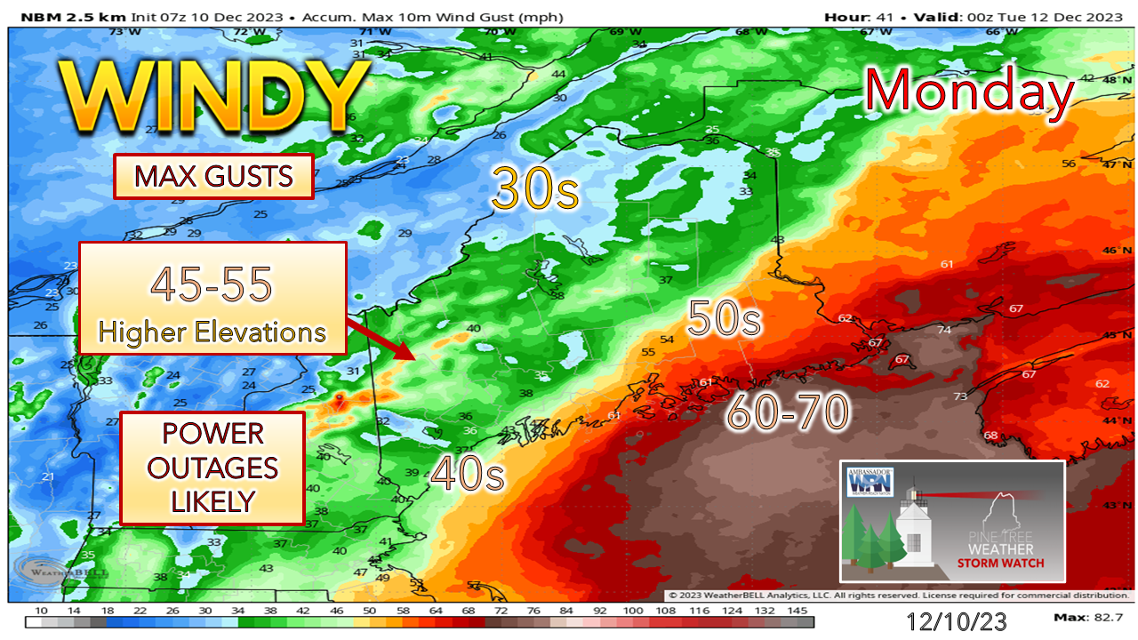 The idea over the past couple of days is the MidCoast and DownEast areas are likely to get the brunt of the gusts, and high wind warnings are posted there. A wind advisory is posted for the southwest coast. Wind speeds gradually increase overnight. The strongest gusts work through the region in the daytime on Monday, ending over southwestern areas by early afternoon, MidCoast areas by mid-afternoon, and eastern areas by late afternoon. There is bust potential here also, more so with the south and west. There is the chance for under performance. It's a tough call. The over/under on power outages from my estimation is around 150,000. I hope I am wrong. With more of a track to the east, numbers may be less. A slight shift west brings more populated areas into play, and the numbers increase. While the strongest gusts end, a stout northwest wind comes in behind the low as it departs, and continues into Tuesday. Expect gusts 20-40 mph overnight on Monday, and 20-30 on Tuesday. MidCoast & DownEast shorelines to get battered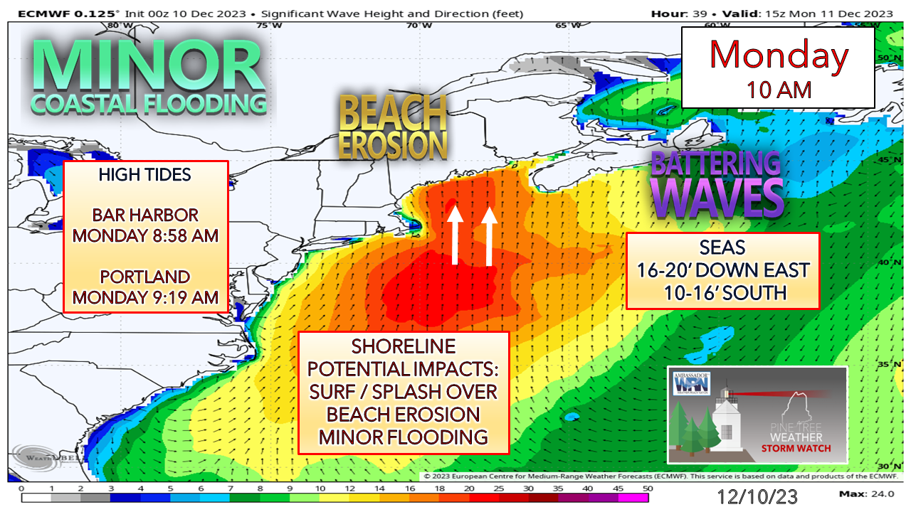 This idea remains consistent. Exposed shorelines to get the surf. The horn of Cape Cod protects areas from Casco Bay south somewhat. The Monday morning high tide and the two hours before and after are the main concern. With the storm passing through in the afternoon, low tide may be abnormally high with surge. While the coast takes a beating, the area has seen worse. It will be rough enough. Stay tuned for coastal flood statements. Temperatures on track to crash in the aftermath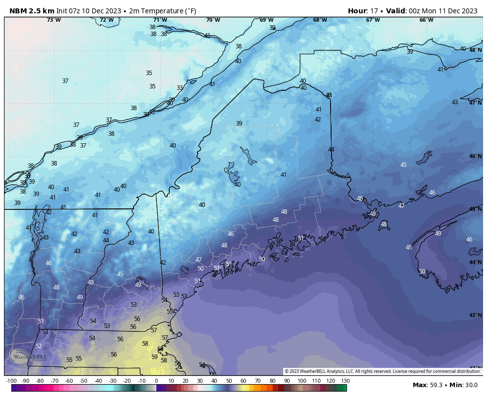 Sunday 7 PM to Tuesday 7 AM - All the standing water freezes up tighter than a drum starting Monday afternoon over the Quebec border area. Expect a skating rink to start Tuesday everywhere with a winds chill ranging from below zero to the teens. Designed for you, supported by you Temperature outlook through the weekI have provided a sampling here of temperature forecasts across the state for recovery purposes. For places over the north and western mountains that ice up in the aftermath, it appears to stay that way as the earliest chance for above freezing temperatures appear to be Friday and that is nominal at best. There are no storms of impact in the near future, which after this slobber knocker, is a good thing. 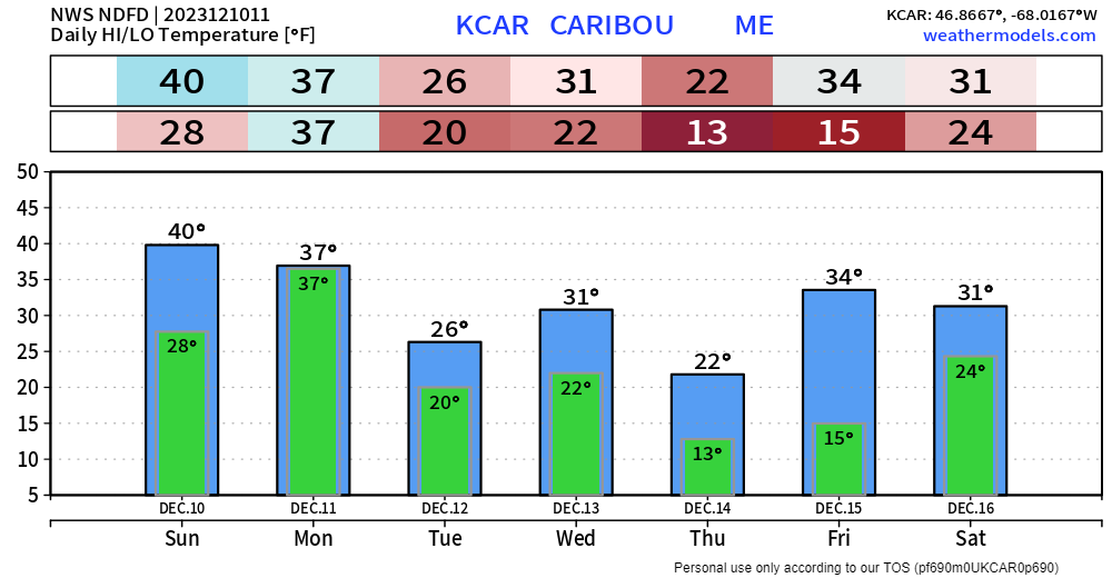 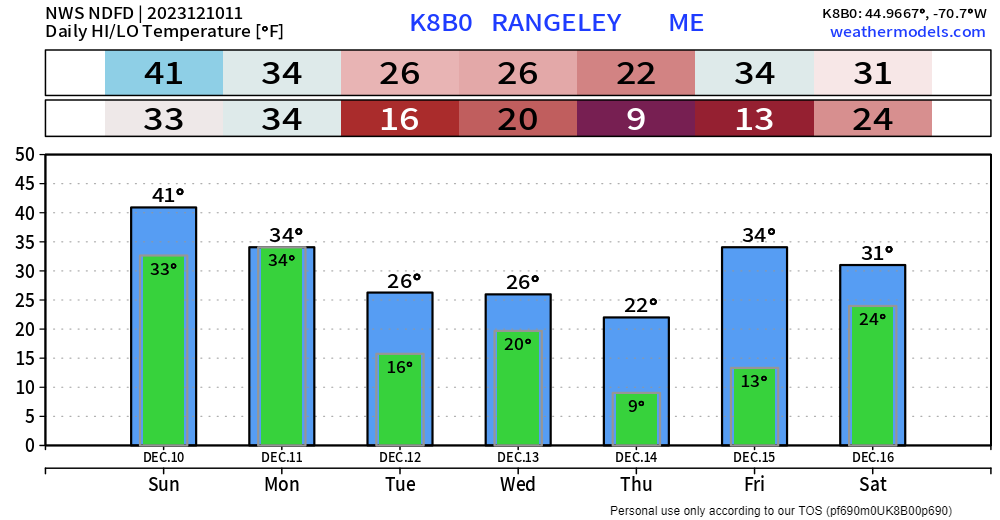 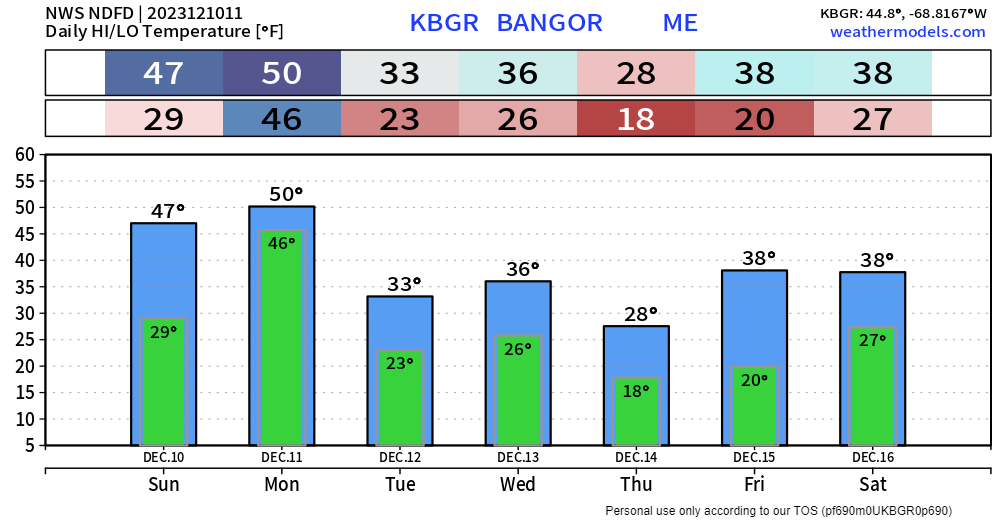 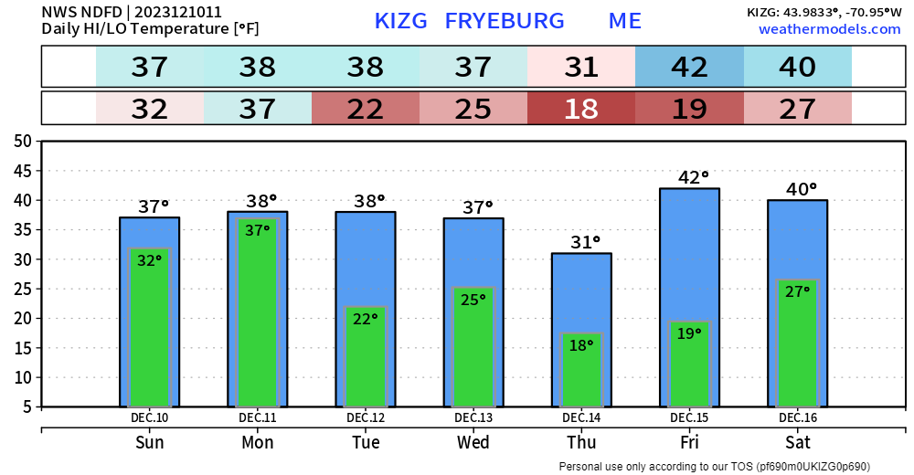  Thank you to Allspeed Cyclery & Snow in Portland, Downeast Aerial Photography in Rockland, Dutch Elm Golf Club in Arundel, and Sunrise Property Services in Bridgton, for partnering with Pine Tree Weather. Special thanks to all the individuals who financially contribute. I sincerely appreciate your support. Stay updated, stay on alert, and stay safe! - Mike PRINT MEDIA: Feel free to quote and cite my work here for your stories. Please give me the professional courtesy of knowing that you are referencing my material so I can read your final product and acknowledge it on my media and link it on the Who I Am page here on the website. Feel free to send me a message via the Facebook page or Twitter (X) to get my phone number if necessary. Thank you! NOTE: The forecast information depicted on this platform is for general information purposes only for the public and is not designed or intended for commercial use. For those seeking pinpoint weather information for business operations, you should use a private sector source. For information about where to find commercial forecasters to assist your business, please message me and I will be happy to help you. |

Mike Haggett
|


