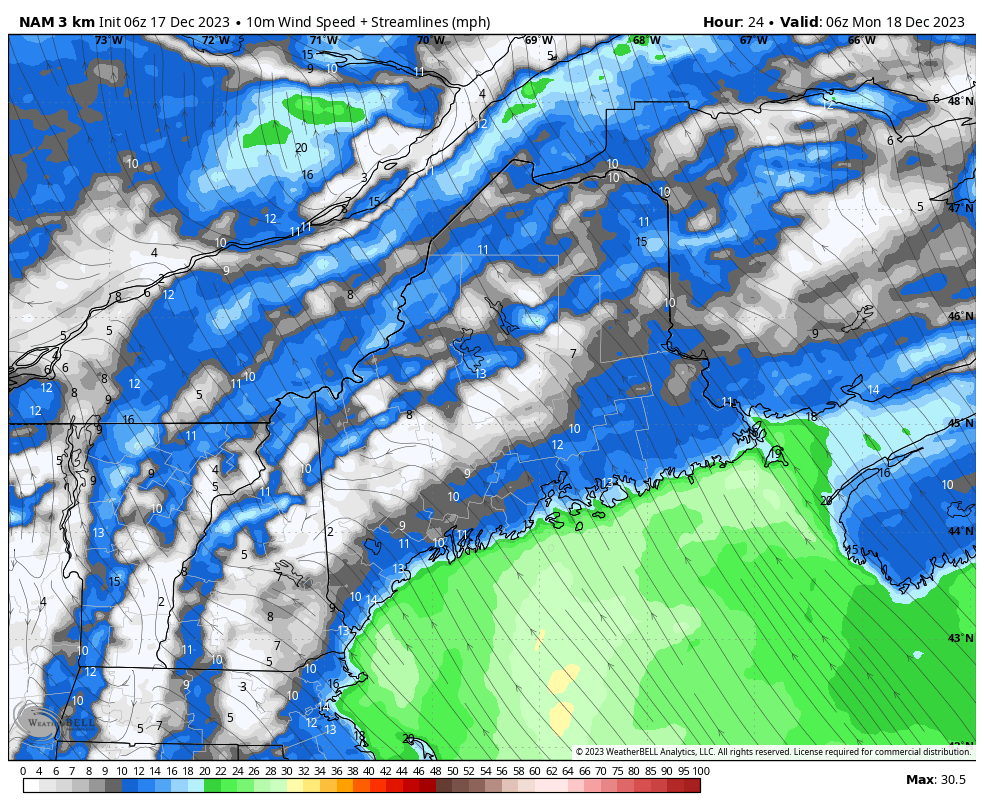
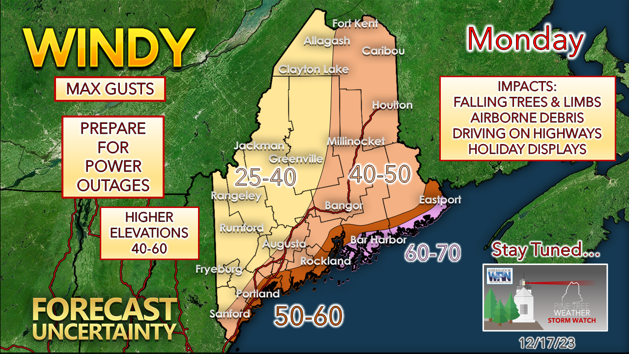
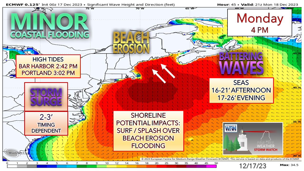
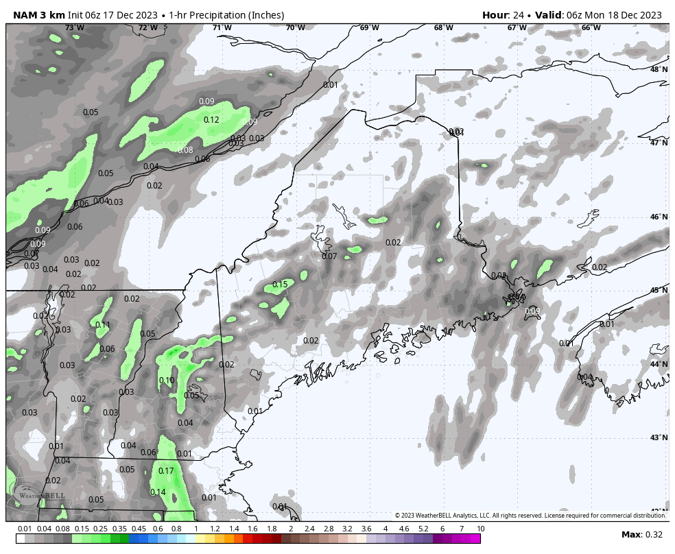
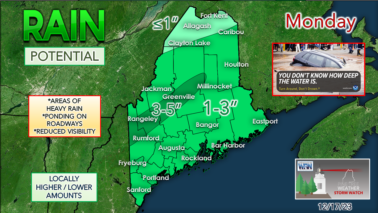
Pine Tree Weather
  • DISCUSSIONS
  • DONATE
  • WEATHER WALL
  • MAPS
  • RAIN OUTLOOK
  • SEVERE
  • MARINE
  • CPC OUTLOOK
  • Kennebunk
  • MY BIO
  • PTW IN MEDIA
  • OBSERVING WEATHER
  • INTERNSHIPS
  • INTERN ALUMNI
  • DISCUSSIONS
  • DONATE
  • WEATHER WALL
  • MAPS
  • RAIN OUTLOOK
  • SEVERE
  • MARINE
  • CPC OUTLOOK
  • Kennebunk
  • MY BIO
  • PTW IN MEDIA
  • OBSERVING WEATHER
  • INTERNSHIPS
  • INTERN ALUMNI

Sunday December 17, 2023

12/17/2023

Comments


The set up

Picture
This will be third Monday storm over the past three weeks that will bring impacts to the region, and this one is shaping up to be the most potent. With more blocking beginning to build in the northern hemisphere as winter astronomically approaches, the risk of strong storms increases and that is what is going on here. A strong ridge with a blocking high to the east, a strong blocking ridge to the west, with an upper level trough driving to the southeast that fires up two areas of low pressure that are expected to spin through the neighborhood through early Tuesday.
Picture
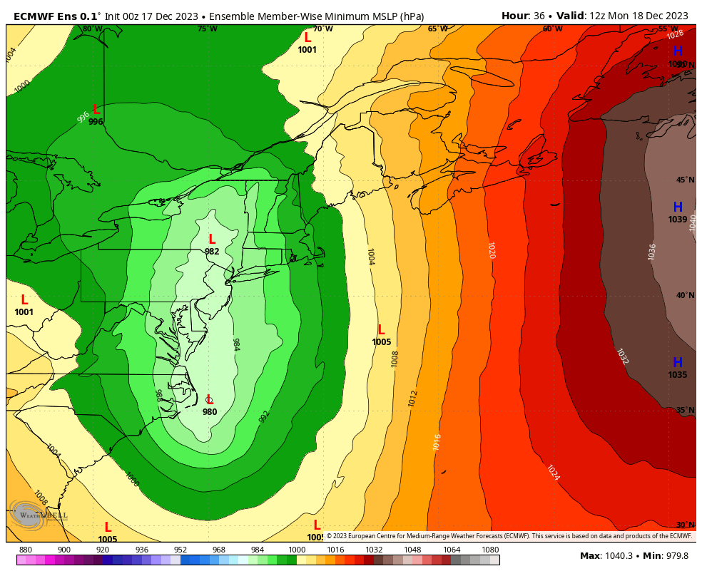
Monday 7 AM to Tuesday 1 PM - The parent low over central New York heads for Montreal as a secondary low gets its act together south of Long Island. As the secondary low tracks into New England, it siphons off energy from the low to the north as is intensifies as it rips through the region for eastern Quebec. In the wake of the system, a cut-off upper-low keeps the region unsettled as is slowly crawls just to the south of the region through the week.

With the idea of a sub-980mb pressure storm with a firm moisture hose attached to it from the Gulf of Mexico, the potential for damaging wind, flash flood potential rainfall, along with a coastal beating are all on the discussion table. 

Potential for two waves of strong wind,
​with questions on the second

Picture
Monday 1 AM to Tuesday 1 AM - Wind speeds begin to increase Monday morning. The wind associated with the parent low tracking to the northwest spins the first wave through around midday. After a brief lull, the second and more potent wave begins to work through the region as the intensifying secondary low slices through southern New England into New Hampshire and western Maine. The strongest gusts appear to peak over the region late Monday afternoon into the evening.

There remains some uncertainty on track and pressure intensity. Like what we've seen recently, model tracks have shifted east. This poses a question mark for southern areas on gusts and impacts to a certain extent. 
Picture
A more of a shift to the east pushes the higher gusts to the east along with it. It's a foregone conclusion that the DownEast shorelines will get the brunt of it, and the case could be made that the MidCoast shorelines and Penobscot Bay areas could see 60+mph gusts as well.

The low-level jet overhead running between 80-100 knots means business.

As I mentioned on Facebook Saturday, an inversion cap comes into play with 50°+ air riding over 40°+ ocean temperature. It may be enough to keep the worst of the wind aloft. That played a role in last Monday's system where the high end gusts underperformed. With this storm being a different breed, with potentially lower pressure and with a track over land, the inversion may take some of the heat of the high speeds off, but hurricane force is not out of the question over the coastal waters, especially eastern parts of the Gulf of Maine. 

Whether or not your area receives a wind advisory or high wind warning does not mean that region escapes without damaging wind. 

While the horizontal threat is real, there also comes the vertical threat with heavy rain dragging downdraft wind aloft to the surface with it. This is especially concerning for those in the mountains, where the bulk of the rain is expected. 

Picture
Strong southeast wind storms have the ability to hammer the exposed areas where there are no island barriers, and that is what we have here. If the timing and track remain consistent with the secondary low, the shorelines could escape with somewhat lesser impacts. It appears that it will be bad enough. Tides are up a bit with the recent moon. The surge comes as the developing low passes through the area later in day, which if that hold serve, there could be enough of a tide drop off the high water mark to keep the worst of it in the ocean. It could be close. With the wind direction pushing water straight at the shoreline, the timing of it is critical. There could be a second round of shoreline abuse with the high tide in the wee hours of Tuesday morning with the surf remaining high, but it does settle a bit after midnight. 

Inland flooding potential

Picture
Picture
Monday 1 AM to Tuesday 1 AM - Heads up for interior areas Sunday night into Monday morning for potential for icing as cold air damming is likely to set up which could slick the roads and untreated surfaces until temperatures rise during the day. 

This is a look at potential 1-hour precipitation which indicates the threat for flash flooding over the western mountains and eastern areas. The thing to keep in mind here is areas of downpours that could occur anywhere southeast of the Allagash that could bring locally intense rainfall rates of 1-3"/hour or higher. It's not so much of the how much falls in an hour, the rate in which it falls and for how long that concerns me. A quick 20-minute power could deliver more of an impact than the same amount of rain over a two hour period or longer with the ground froze like cement. 

Monday evening commute could be rough with the peak of wind and heavy rain. 
Picture
I am not going to sugar coat it, this is bad news for ski country with slopes facing southeast. There will be fog there, also, which just eats the snowpack more than actual rain. I suspect there will be some roads washed out for the reasons I have outlined. Urban street flooding is not out of the question. Hydroplane potential on the speedier roads. 

The region appears to be caught in the warm sector heading into Tuesday, with no cooling to take place until Tuesday night. This will help rainfall to drain out and dry up where it can. 

The snowmakers can get the guns going Tuesday night and try to get bases built for Christmas week. 

Stay tuned for updates as the finer details of the forecast iron out.

Prepare to lose power and to potentially to clean up a mess. 

​Designed for you, supported by you

Picture

Thank you to Allspeed Cyclery & Snow in Portland, Downeast Aerial Photography in Rockland, Dutch Elm Golf Club in Arundel,
and Sunrise Property Services in Bridgton, for partnering with Pine Tree Weather.

Special thanks to all the individuals who financially contribute.
​I sincerely appreciate your support. 


Stay updated, stay on alert, and stay safe!

- Mike

PRINT MEDIA: Feel free to quote and cite my work here for your stories. Please give me the professional courtesy of knowing that you are referencing my material so I can read your final product and acknowledge it on my media and link it on the Who I Am page here on the website. Feel free to send me a message via the Facebook page or Twitter (X) to get my phone number if necessary. Thank you! ​

​NOTE: The forecast information depicted on this platform is for general information purposes only for the public and is not designed or intended for commercial use. For those seeking pinpoint weather information for business operations, you should use a private sector source. For information about where to find commercial forecasters to assist your business, please message me and I will be happy to help you.

Comments
    Picture

    Mike Haggett
    Kennebunk, ME

    Weather-Ready Nation
    Ambassador

    Certified Weather
    Forecaster
    Penn State '21

    American Meteorological Society

    National Weather Association
    ​
    ​SKYWARN-CWOP

    Matthew 19:26


    DONATE

    Picture
    Picture
    Picture
    Picture
    Picture

    Picture

    Picture

    Picture

    Picture

    Picture

    Picture

    Picture

    Picture

    Picture

    Picture

    Picture

    Picture


    Archives

    May 2025
    April 2025
    March 2025
    February 2025
    January 2025
    December 2024
    November 2024
    October 2024
    September 2024
    August 2024
    July 2024
    June 2024
    May 2024
    April 2024
    March 2024
    February 2024
    January 2024
    December 2023
    November 2023
    October 2023
    September 2023
    August 2023
    July 2023
    June 2023
    May 2023
    April 2023
    March 2023
    February 2023
    January 2023
    December 2022
    November 2022
    October 2022
    September 2022
    August 2022
    July 2022
    June 2022
    May 2022
    April 2022
    March 2022
    February 2022
    January 2022
    December 2021
    November 2021
    October 2021
    September 2021
    August 2021
    July 2021
    June 2021
    May 2021
    April 2021
    March 2021
    February 2021
    January 2021
    December 2020
    November 2020
    October 2020
    September 2020
    August 2020
    July 2020
    June 2020
    May 2020
    April 2020
    March 2020
    February 2020
    January 2020
    December 2019
    November 2019
    October 2019
    September 2019
    August 2019
    July 2019
    June 2019
    May 2019
    April 2019
    March 2019
    February 2019
    January 2019
    December 2018
    November 2018
    October 2018
    September 2018
    August 2018
    July 2018
    June 2018
    May 2018
    April 2018
    March 2018
    February 2018
    January 2018
    December 2017
    November 2017
    October 2017

Proudly powered by Weebly