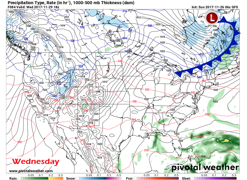
Pine Tree Weather
  • DISCUSSIONS
  • DONATE
  • MAPS
  • NWS BRIEFINGS
  • SATRAD
  • MARINE
  • SNOW / ICE OUTLOOK
  • RAIN OUTLOOK
  • CPC OUTLOOK
  • Kennebunk
  • OBSERVING WEATHER
  • Who We Are
  • My Photography
  • DISCUSSIONS
  • DONATE
  • MAPS
  • NWS BRIEFINGS
  • SATRAD
  • MARINE
  • SNOW / ICE OUTLOOK
  • RAIN OUTLOOK
  • CPC OUTLOOK
  • Kennebunk
  • OBSERVING WEATHER
  • Who We Are
  • My Photography

Sunday update: Mixed bag may slick roads in areas

11/26/2017

Comments


Rain changes to snow

Picture
Futurecast radar from the HRRR model shows areas of rain showers changing to snow as the frontal boundary progresses. A second wave brings snow shower activity back to the region Sunday evening. 

Folks travelling over the interior and eastern areas should expect precipitation change and potential slick spots forming through the day. This should not pose widespread problems, and will be certainly negotiable as long as reduced speeds and caution exhibited around intersections are used.
Picture
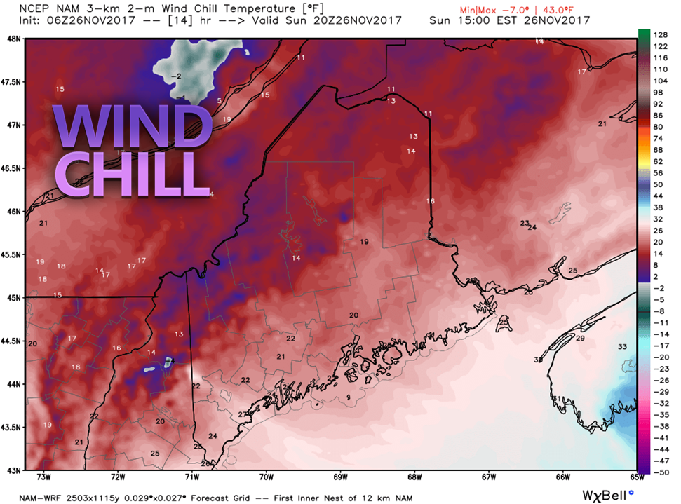
With temperatures starting off on the mild side for parts of the state this morning, the front changes that with steadily falling temperatures through the day. A west/northwest wind will pick up, and by mid-afternoon wind chill values in the teens and 20s will be prevalent around the region.

Snow showers for some Monday morning

Picture
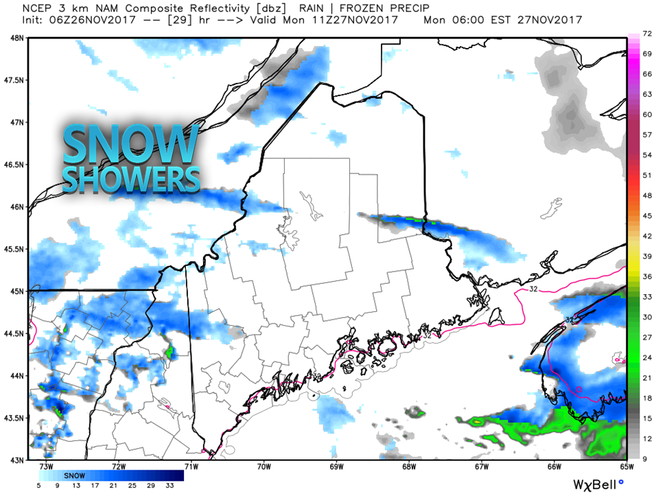
By the time the school buses roll early Monday, most areas appear clear of any new accumulation. Any snow showers around will dissipate through the morning.

The west / northwest wind appears to continue to keep most areas feeling like the teens and 20s through the day.

High pressure moves in during the afternoon and settles over the state Monday night, which will slack the breeze for most by midnight Tuesday. 
Picture
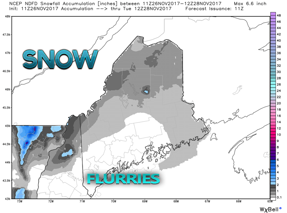
Total snowfall from National Weather Service ideas shows the bulk over Quebec border. The mountains and ski hills should pick up a couple of inches out of this by the time this is over.

Another weak front for Wednesday;
​system to watch for late week

Picture
Low pressure cuts across central Canada, hits St. James Bay, intensifies, then races off toward Labrador. A weak frontal boundary associated with that low slides through the region on Wednesday. A light rain/snow/mix is possible with this event. Details on this system to come.

Looking at the weekend, a long wave front could bring widespread rain to start off Friday. There is potential for  low pressure to form along the front and enter into the Gulf of Maine on Saturday. This brings the chance for snow to impact several parts of the area Saturday. Many questions and not many answers on this event, and I will update on this through the week.

​- Mike
Comments
    Picture

    Mike Haggett
    Kennebunk, ME

    Certified Weather
    Forecaster
    Penn State '21

    American Meteorological Society

    National Weather Association

    Weather-Ready Nation 
    Ambassador
    ​
    ​SKYWARN-CWOP

    Matthew 19:26


    Support
    Pine Tree Weather

    DONATE

    Picture

    Picture

    Picture

    Picture

    Picture

    Picture

    Picture

    Picture

    Picture

    Picture

    Archives

    January 2023
    December 2022
    November 2022
    October 2022
    September 2022
    August 2022
    July 2022
    June 2022
    May 2022
    April 2022
    March 2022
    February 2022
    January 2022
    December 2021
    November 2021
    October 2021
    September 2021
    August 2021
    July 2021
    June 2021
    May 2021
    April 2021
    March 2021
    February 2021
    January 2021
    December 2020
    November 2020
    October 2020
    September 2020
    August 2020
    July 2020
    June 2020
    May 2020
    April 2020
    March 2020
    February 2020
    January 2020
    December 2019
    November 2019
    October 2019
    September 2019
    August 2019
    July 2019
    June 2019
    May 2019
    April 2019
    March 2019
    February 2019
    January 2019
    December 2018
    November 2018
    October 2018
    September 2018
    August 2018
    July 2018
    June 2018
    May 2018
    April 2018
    March 2018
    February 2018
    January 2018
    December 2017
    November 2017
    October 2017

    RSS Feed

Proudly powered by Weebly