
PrefaceOne thing I don't discuss with any regularity at all is historical events. My time to forecast is limited, so I don't talk too much about past events. I do look at records quite often as the past at times can and does repeat itself. For the past eleven Octobers I have seen these dates come and go. One particular record sticks out more than any other: October 21, 1996, Portland, Maine received 11.74" of rainfall. Add in the previous day total of 2.78" on October 20th, the combined two-day total reached 14.52". It's a record that blows away any other rainfall total (or liquid equivalent in snow) by a wide margin, with second place going to August 19, 1991, where 7.75" was recorded in one day, from Hurricane Bob. Seeing this record prompted me to do some research and find out the how and the why. Amazingly enough, there is little history online about it, hence the title. Outside of a couple of published columns by the National Weather Service and the United States Geological Service that had to be dug for, it was if the event didn't happen. Maine has experienced some significant storms in October over the years, and each one had a common ingredient... tropical influence. Whether it was the Perfect Storm of 1991, Tropical Storm Tammy in 2005, Hurricane Sandy in 2012, The October Gale of 2017, or others, the tropics played a major role with impacts and outcome. In this case, which is exactly what happened with this one. Hurricane Lili hooks up with a cut-off upper-level low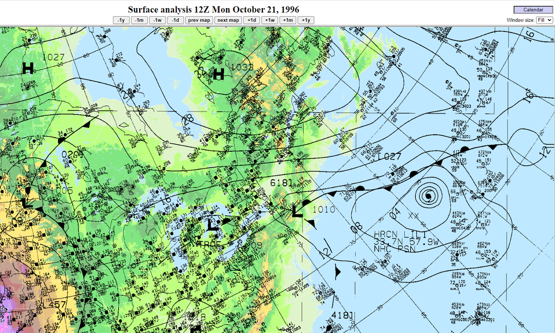 This archive map from Weather Prediction Center shows extratropical-Hurricane Lili well to the east. A blocking ridge over Northern Quebec created a traffic jam and slowed down Lili's progress to the North Atlantic. A cut-off upper-level low over the northeast was also hung up as a result of the blocking ridge. A stationary front set up. The upper-low tapped into Lili's moisture with help from the high pressure associated with the ridge and syphoned it northeast.  This satellite photo shows a well-organized Lili south of Newfoundland and the cut-off upper-low making the connection. The funnel of precipitation from Lili transferred along the stationary front to Maine.  A better view of the synoptic influence of the cut-off upper-level low and Lili is depicted here. The blocking high helped feed the moisture from Lili to the upper-level low. With all three gears locked together and not moving. an atmospheric river like none recorded before over Maine and was stuck with no place to go. In meteorological terms, this is known as entrainment. Relentless rainfall for over 40 hours in areasThree radar loops to show beginning, middle and end... 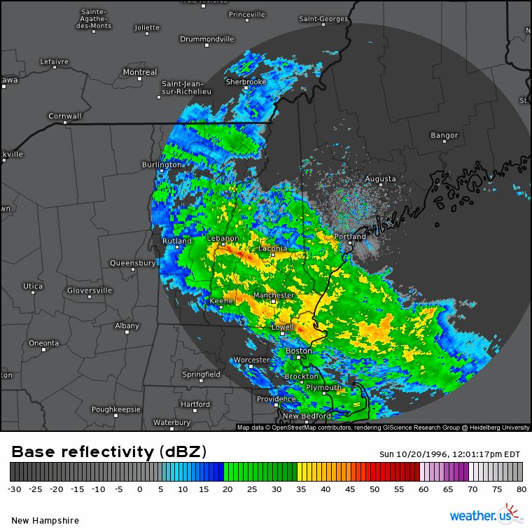 Important to note here that Boston ended up with a two-day total of 7.89" (6.11" October 20th, 1.78" October 21st), which ended up being roughly half of what Portland received. The shower and thunderstorm activity were tapering off there as the atmospheric river went into full-on fire hose 70 miles to the north. Impact reports began to roll in: 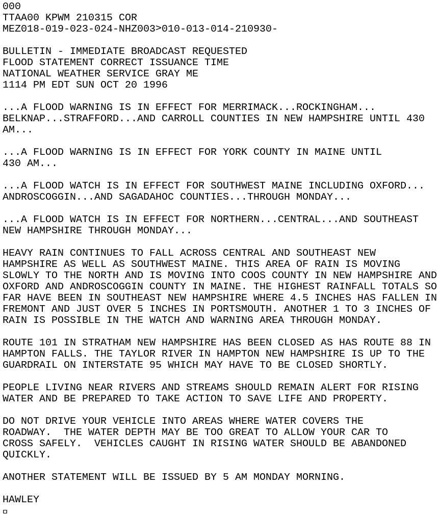 The early morning precipitation and wind reports indicated a precursor of what was to come for Southern Maine: 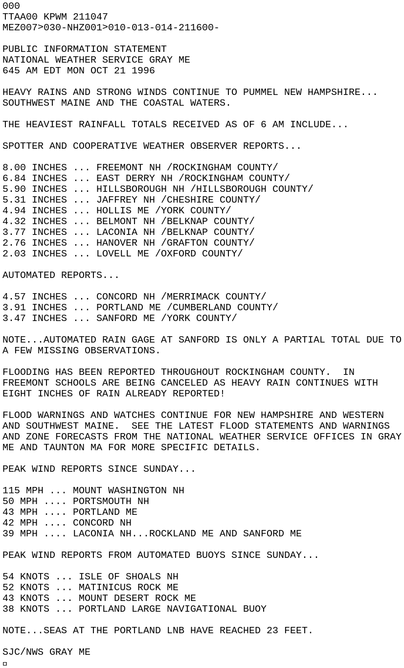 And the train kept going... 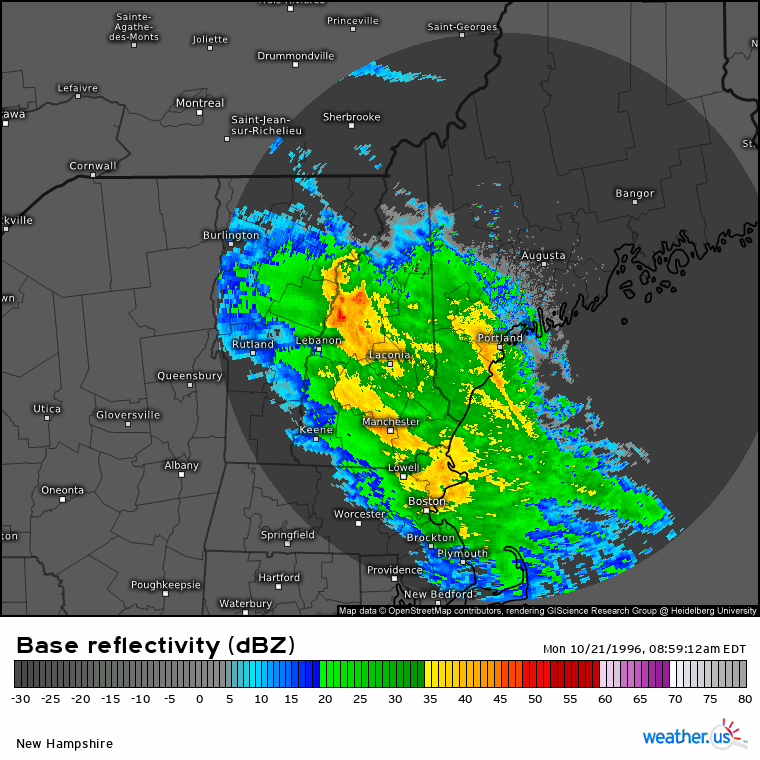 As the ridge to the north relaxed a bit, it allowed eastern Massachusetts and southern New Hampshire to dry out, but the moisture pump from the stationary front between the cut-off upper-level low and Lili continued at full throttle over southern and western Maine with no let down. 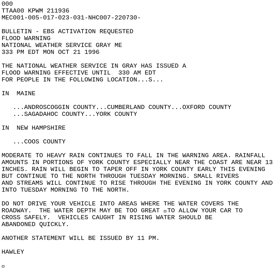 The ridge to the north relaxed a bit more by Monday night and ended rain over the south and shifted the front northward. At that point Lili was able to move out to the northeast and the connection between the cut-off upper-level low and the tropical system, allowing the heavy rain to end. 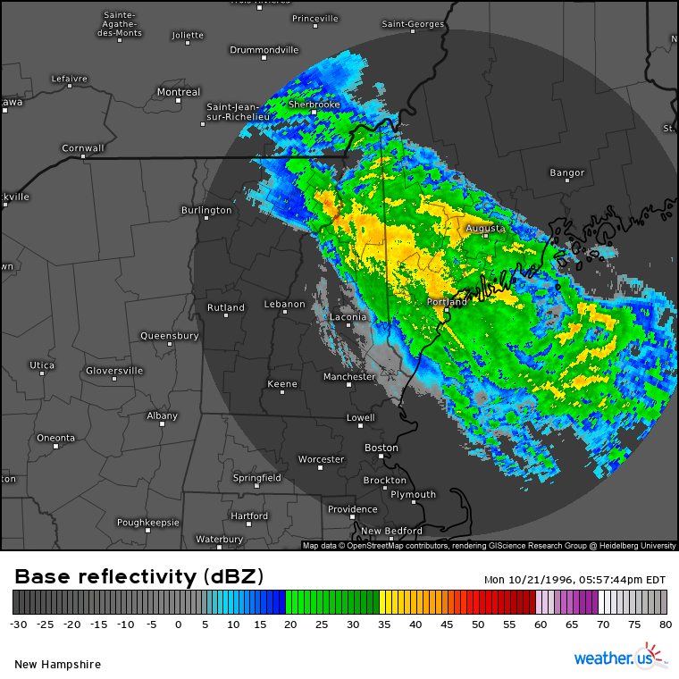 Rain tapered off to showers as the source of moisture was cut off. After the onslaught of torrential rain for forty hours, it was finally over. Historic rainfall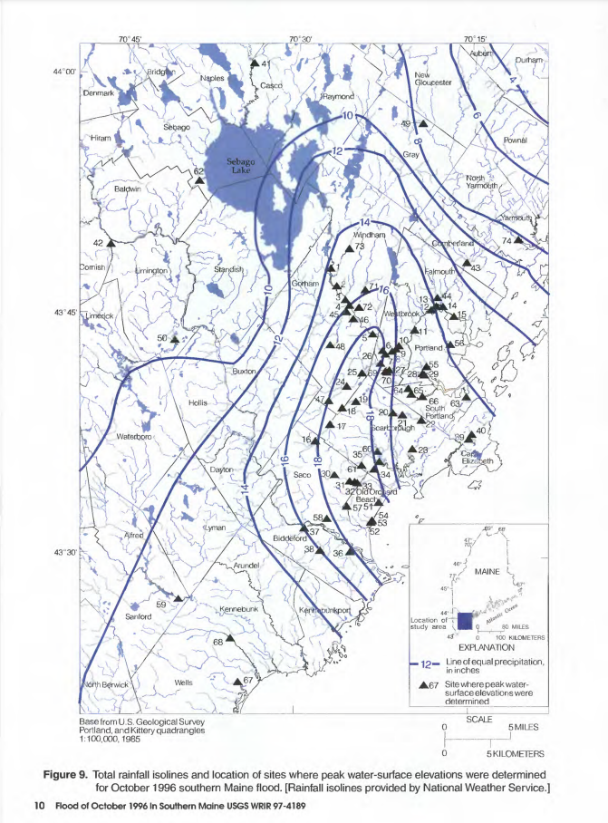 The contours of the precipitation chart above show a range of 4" or less to the northeast around Durham, to 18"+ from Old Orchard Beach to Gorham. The sharp gradient from the main axis of entrainment was also noted from SKYWARN weather spotters, co-op observers, and automated stations: 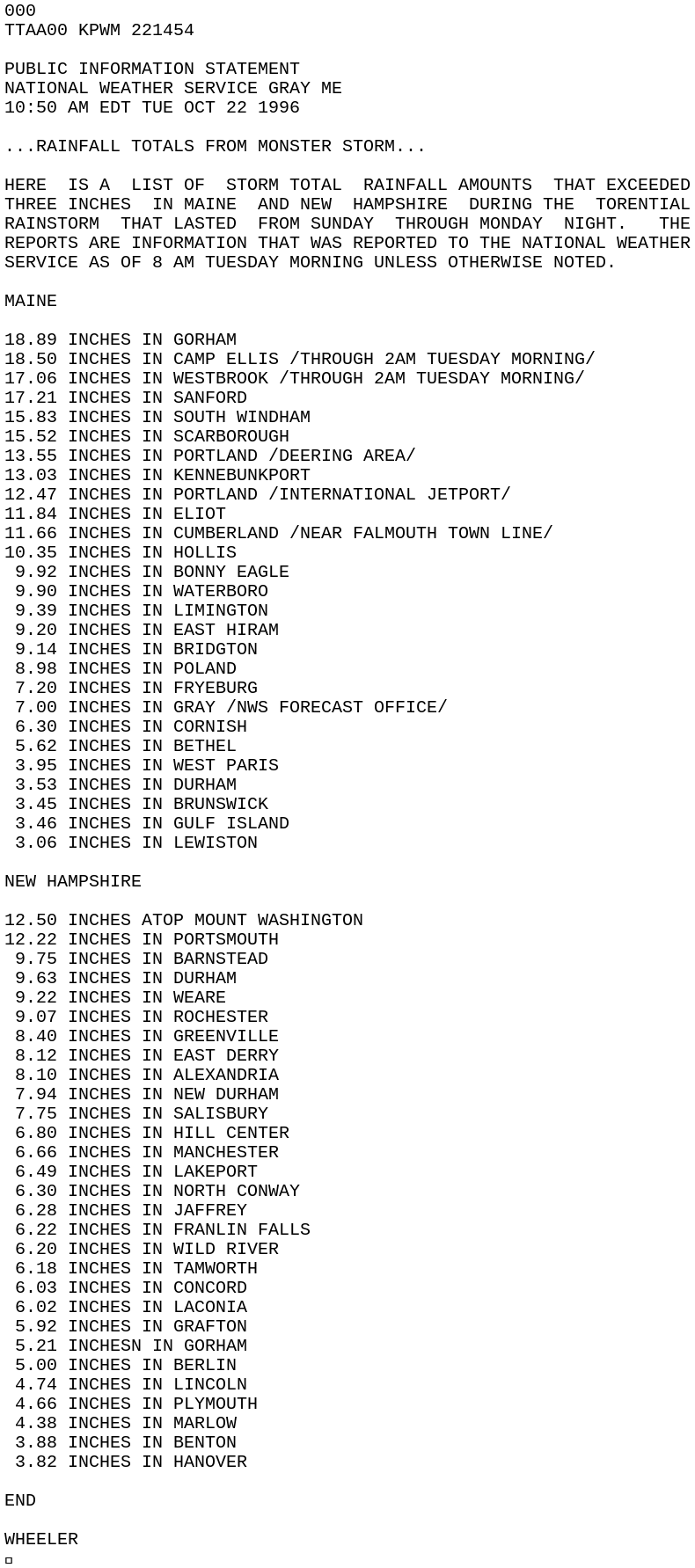 When all the reports came in, one final list was dispatched by NWS Gray: 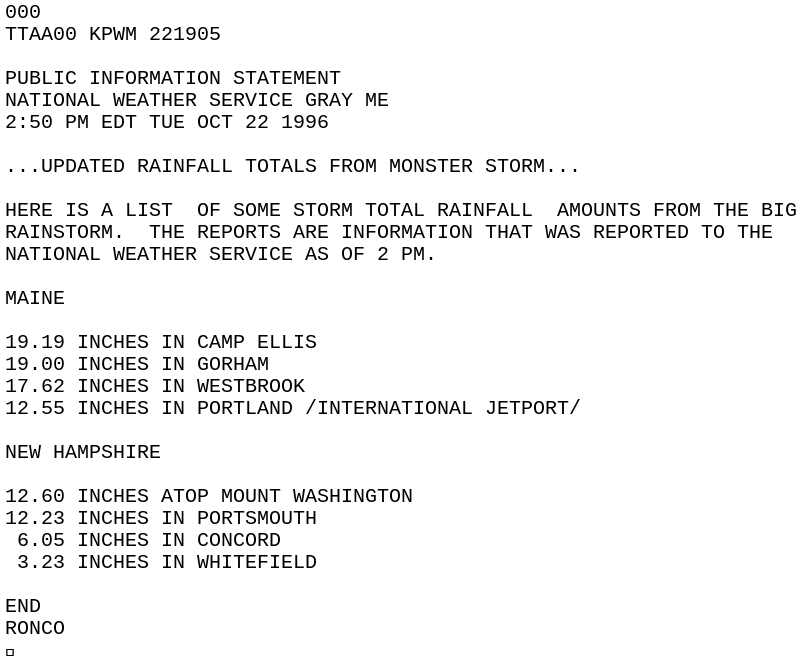 After further post storm analysis, it was determined that Camp Ellis final official report was 19.21", a Maine state record. This amount is just shy of the New England record of 19.76 which was a result of Hurricane Diane in Westfield, Massachusetts in August 1955. The aftermath These photos of the Presumpscot River show the inundation around Tee n' Tee Golfland and Dunkin Donuts (top) and the highwater mark from the street view below. The traffic lights are at the intersection of East Bridge Street in Westbrook.   York and Cumberland Counties were declared federal disaster areas. The cost breakdown of the storm: Cumberland $4,924,698, Oxford $161,185, York $3,431.581, Individual Assistance Program $460,000, and State Agencies $456,307, for a total of $9,433,771 in 1996 dollars. Do you have any photos or memories of this storm? Please contact me on Facebook or Twitter. AcknowledgementsMany thanks to National Weather Service Gray lead meteorologists John Cannon, Maura Casey, and Warning Coordination Meteorologist Donald Dumont, The Maine Emergency Management Agency's Public Outreach Specialist Amy Carole, Public Assistance Program Manager Naomi Petley, along with Weather.us, Iowa State University Environmental Mesonet, and the United States Geological Service.
Published articles used in reference to this column for more information: A Hydrometeorological Assessment of the October 1996 Record Rainstorm in Maine by John Cannon, National Weather Service Gray, Maine Flood of October 1996 in Southern Maine by the USGS - Mike Haggett |

Mike Haggett
|


