Severe thunderstorms possible for parts of Maine Monday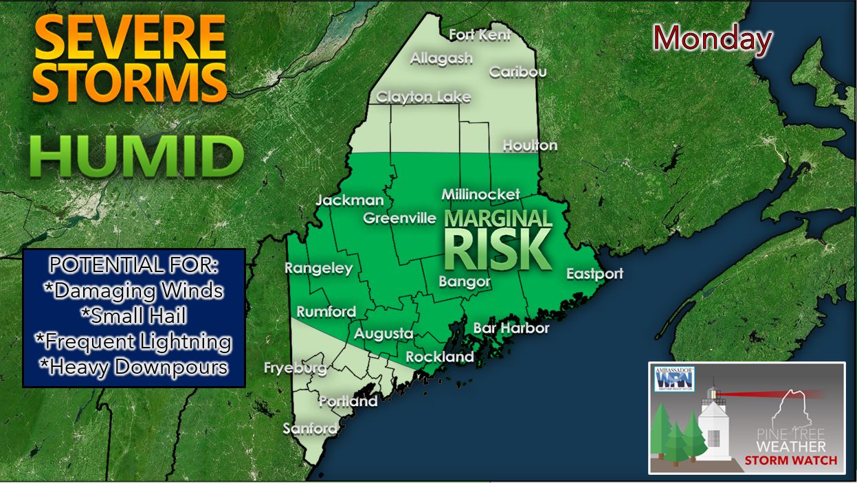 We should see any leftover areas of rain taper off to showers across the state as we head into the late evening hours on Sunday. Sunday night we can expect low temperatures to drop into the lower 50's across northern Maine with lower 60's likely for the coastal locations in southern Maine. Areas of patchy fog are likely to develop by daybreak Monday across the state given the ample low-level moisture present behind the warm front that crossed the region on Sunday. The Storm Prediction Center has put the central portion of the state in the marginal risk area for severe thunderstorms on Monday. A marginal risk of severe weather means there is the potential for isolated thunderstorms that could produce damaging winds, small hail, frequent lightning, and heavy downpours. An upper trough in eastern Canada extending south across our region along with a cold front stalling nearby should provide sufficient atmospheric instability as well as cold air aloft to produce isolated instances of damaging winds and small hail. These seem to be the primary threats from any severe thunderstorms that do develop on Monday afternoon and evening. Humid conditions likely Monday and Tuesday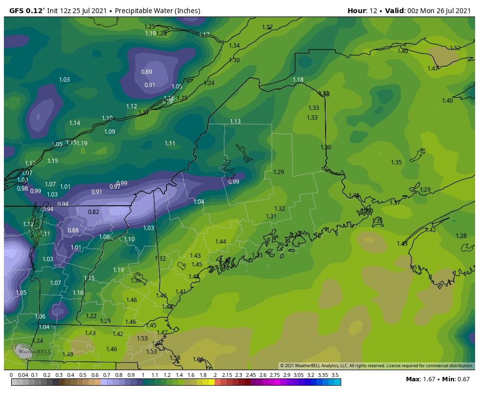 This is a graphic depicting precipitable water values throughout the state through the day on Wednesday. Precipitable water measures the amount of water that exists in the entire vertical column of the atmosphere at each chosen location. Precipitable water values are around the 1 to 1.50 inch range across coastal Maine which indicates moderate to high available atmospheric moisture and fairly high humidity on Monday. Dewpoints on Monday will likely be in the upper 60's for the coastal locations resulting in a somewhat uncomfortable day outside. Precipitable water values on Tuesday could be over 1.50 inches in some portions of the southern part of the state with dewpoints still sticky in the low to mid-60's for coastal Maine. For Wednesday, there will be a ridge of high pressure moving into the state ushering in a comfortable air mass with low precipitable water values. Another chance of thunderstorms on Tuesday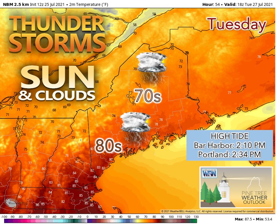 On Tuesday, there will be another chance of showers and thunderstorms across the state. At this time, the thunderstorms that develop on Tuesday are expected to be below the severe threshold. It can't be ruled out at this early stage that some of the thunderstorms could contain gusty winds and locally heavy rainfall especially across southern Maine on Tuesday in the vicinity of a shortwave moving along a secondary cold front. The thunderstorms should move across the state from northwest to southeast on Tuesday. By Tuesday night, an area of high pressure associated with a trough in eastern Canada should move into the state drying us out. Precipitation chances into next weekend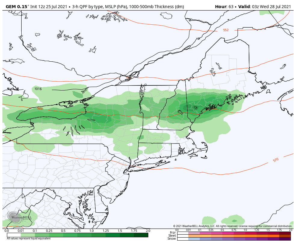 On Wednesday, we can expect an area of high pressure to move across the state resulting in a comfortable day with mostly sunny skies and light winds. High temperatures on Wednesday will likely range from the 60's in the higher terrain of western Maine to the 70's across interior Maine. Our next chance of precipitation arrives on Thursday afternoon as we watch another shortwave approach the state. This could bring a steady rainfall across the state into Friday morning which would help alleviate the drought situation in the mountains of western Maine. Friday should be partly to mostly sunny with low humidity and comfortable temperatures similar to Wednesday as another area of high pressure moves toward the region. On Saturday, we may see precipitation return to the state once again. Long range pattern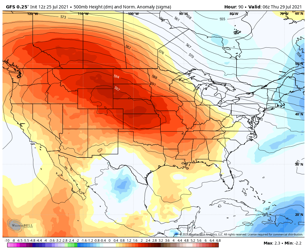 Heading into next weekend and into the start of the following week, we are projected to be stuck in a cool and unsettled pattern across Maine. This is due to a trough that will be centered over eastern Canada keeping our heights low while the core of the ridge remains across the southeast US back into the western US. Stay safe in the sun: UV safety In the summer, the sun angle at solar noon is the highest it will be all year. Therefore, it is important to be mindful of how to protect yourself from the sun's rays if you are working or vacationing outside. Some tips to protect yourself or others are: seek shade between 10am and 4pm, apply sunscreen 15 minutes before heading outside, check the UV index each day, and protect children and the elderly who may be more sensitive to the sun. Temperature outlook into early AugustThe temperature plots below show the projected daily high/low temperatures for Carrabassett, Bangor, Caribou, and Portland over the next 7 days compared to the average temperatures expected in each city this time of year. After average to above average temperatures expected early in the week, our temperatures will likely trend towards below average heading into next weekend and early the following week. 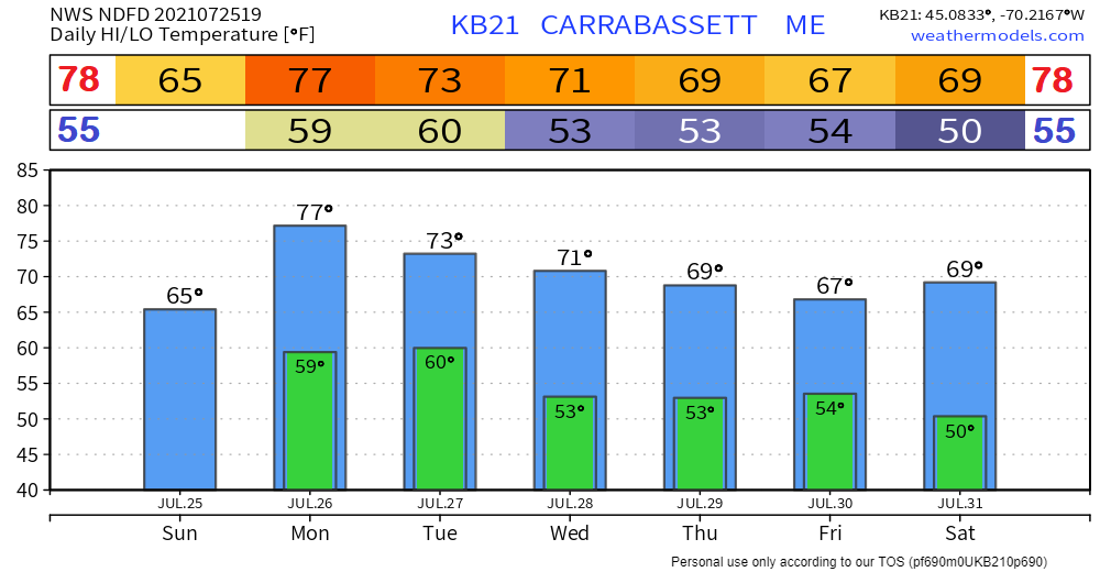 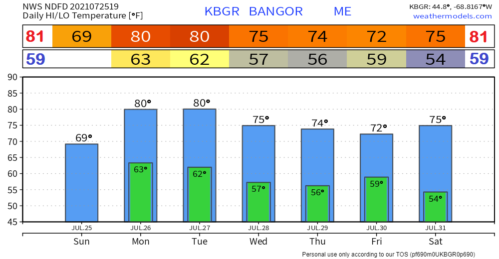 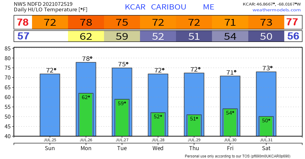 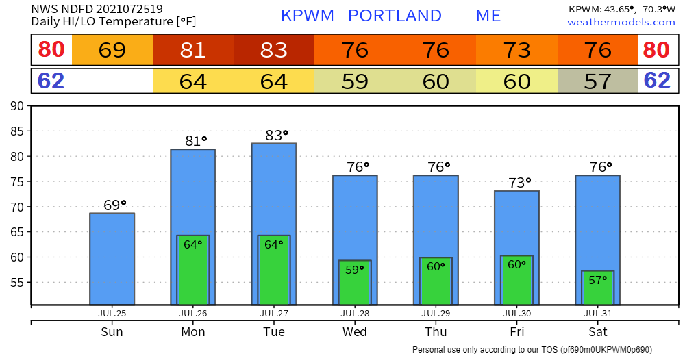 Be prepared to receive alerts and stay updated!
For more information in between posts, please follow Pine Tree Weather on Facebook and Twitter.
Thank you for supporting this community-based weather information source which operates by reader supported financial contributions. Stay updated, stay on alert, and stay safe! |

Mike Haggett
|