Pine Tree Weather
  • DISCUSSIONS
  • WHO I AM
  • DONATE
  • MAPS
  • NWS BRIEFINGS
  • SATRAD
  • MARINE
  • SNOW / ICE OUTLOOK
  • RAIN OUTLOOK
  • CPC OUTLOOK
  • Kennebunk
  • OBSERVING WEATHER
  • INTERN ALUMNI
  • My Photography
  • DISCUSSIONS
  • WHO I AM
  • DONATE
  • MAPS
  • NWS BRIEFINGS
  • SATRAD
  • MARINE
  • SNOW / ICE OUTLOOK
  • RAIN OUTLOOK
  • CPC OUTLOOK
  • Kennebunk
  • OBSERVING WEATHER
  • INTERN ALUMNI
  • My Photography

Thursday August 24, 2023

8/24/2023

Comments


Steering level overview and outlook

Picture
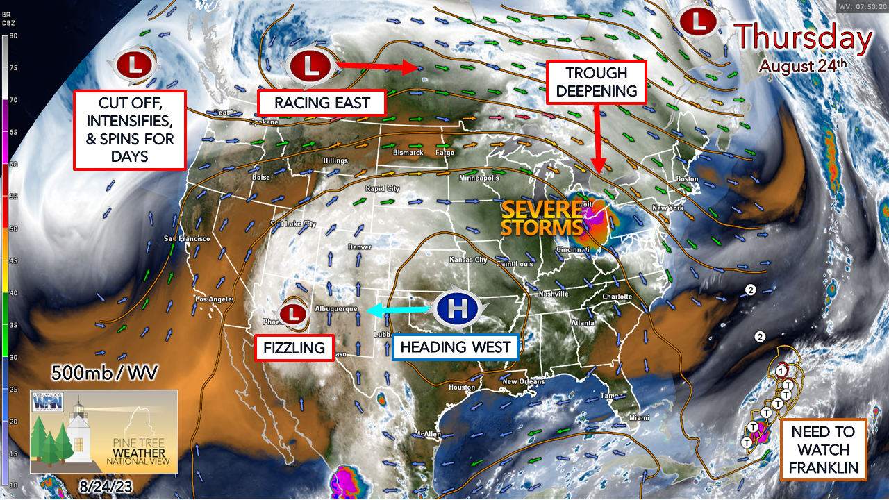
The 500mb steering level over the continent is about to shift sharply into a pattern that resembles mid-fall. Given the time of year and the amount of available daylight to heat the atmosphere, it will take a bit of time for the temperatures to catch up to it and cool down. We've had a taste of it in the past couple of mornings with cool, comfortable, below normal starts. With the transition to fall already occurring in the overall pattern, there will be more of that. 
Picture
Thursday 8 AM to Tuesday 8 AM - The forecast steering level put into motion here over the next few days shows a few things. It's basically full-on winter in the Arctic above Hudson Bay noted with the greens and blues. The death ridge over the south is in the process of being shoved to the west but will grow taller and reach into the Yukon by early next week. Incredible blocking over the Atlantic and the deepening trough over the east is where I have some concerns. The upper-low associated with TS Franklin moves northward and could be a CAT2 hurricane affecting Bermuda early next week. The long-term ideas point to more of a concern for the Canadian Maritimes than Maine, but it is too early to write it off. That is ridiculous blocking ridge over the Atlantic, and with the deepening trough to the west over the Great Lakes, it is all about timing and strength of all the ingredients there that will determine where Franklin goes. 

Showers and storms Friday & Saturday,
​showers possible Sunday

Picture
Thursday 8 PM to Sunday 1 PM - Models ideas are flipping around with an assortment of ideas with the development of a surface low ahead of the deepening trough for the weekend.  This is shaping up to be a slow mover that will bring the best chance for showers and storms Friday and Saturday, with a weaker trailing wave to pass through on Sunday that could bring some showers as well. The severe storm threat appears very low at this point, but an isolated threat can't be ruled out. 

Some wind is expected on Friday that could range in the 20-30 mph range for the coast and mountains, but nothing of any power outage concern.
Picture
The low gets an injection of moisture from the south and could bring another inch or two of rainfall across much of the region. The areas that have the best chance to see 2"+ are MidCoast and DownEast areas along with the mountains. Flash flood guidance is still high. While I do not expect a flood watch, there is a fair chance for localized statements being issued.

​​Pine Tree Weather is funded from followers like you.
I would appreciate your financial support. 
Click here for how you can contribute.


You may not like the weather, but I hope you like what I do,
and support my efforts.

​
Thank you!

Stay updated, stay on alert, and stay safe!

- Mike

​NOTE: The forecast information depicted on this platform is for general information purposes only for the public and is not designed or intended for commercial use. For those seeking pinpoint weather information for business operations, you should use a private sector source. For information about where to find commercial forecasters to assist your business, please message me and I will be happy to help you

Comments
    Picture

    Mike Haggett
    Kennebunk, ME

    Weather-Ready Nation
    Ambassador

    Certified Weather
    Forecaster
    Penn State '21

    American Meteorological Society

    National Weather Association
    ​
    ​SKYWARN-CWOP

    Matthew 19:26


    Please
    Support
    Pine Tree Weather

    DONATE

    Picture

    Picture

    Picture

    Picture

    Picture

    Picture

    Picture

    Picture

    Picture

    Picture

    Picture

    Archives

    September 2023
    August 2023
    July 2023
    June 2023
    May 2023
    April 2023
    March 2023
    February 2023
    January 2023
    December 2022
    November 2022
    October 2022
    September 2022
    August 2022
    July 2022
    June 2022
    May 2022
    April 2022
    March 2022
    February 2022
    January 2022
    December 2021
    November 2021
    October 2021
    September 2021
    August 2021
    July 2021
    June 2021
    May 2021
    April 2021
    March 2021
    February 2021
    January 2021
    December 2020
    November 2020
    October 2020
    September 2020
    August 2020
    July 2020
    June 2020
    May 2020
    April 2020
    March 2020
    February 2020
    January 2020
    December 2019
    November 2019
    October 2019
    September 2019
    August 2019
    July 2019
    June 2019
    May 2019
    April 2019
    March 2019
    February 2019
    January 2019
    December 2018
    November 2018
    October 2018
    September 2018
    August 2018
    July 2018
    June 2018
    May 2018
    April 2018
    March 2018
    February 2018
    January 2018
    December 2017
    November 2017
    October 2017

    RSS Feed

Proudly powered by Weebly