Pine Tree Weather
  • DISCUSSIONS
  • DONATE
  • WEATHER WALL
  • MAPS
  • RAIN OUTLOOK
  • SEVERE
  • MARINE
  • CPC OUTLOOK
  • Kennebunk
  • MY BIO
  • PTW IN MEDIA
  • OBSERVING WEATHER
  • INTERNSHIPS
  • INTERN ALUMNI
  • DISCUSSIONS
  • DONATE
  • WEATHER WALL
  • MAPS
  • RAIN OUTLOOK
  • SEVERE
  • MARINE
  • CPC OUTLOOK
  • Kennebunk
  • MY BIO
  • PTW IN MEDIA
  • OBSERVING WEATHER
  • INTERNSHIPS
  • INTERN ALUMNI

Thursday December 28, 2023

12/28/2023

Comments


The steering level begins to move

Picture
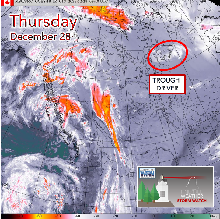
I can already hear it now. Mike, have you gone nuts? Why are you showing us this light ball of fluff over the Northwest Territories? It's the hand that holds the cards for how the steering pattern plays out through Saturday and is the table setter for what is to come for next week. It looks irrelevant, that little gem riding over the western ridge is what is going to touch off a chain reaction and move things along.  
Picture
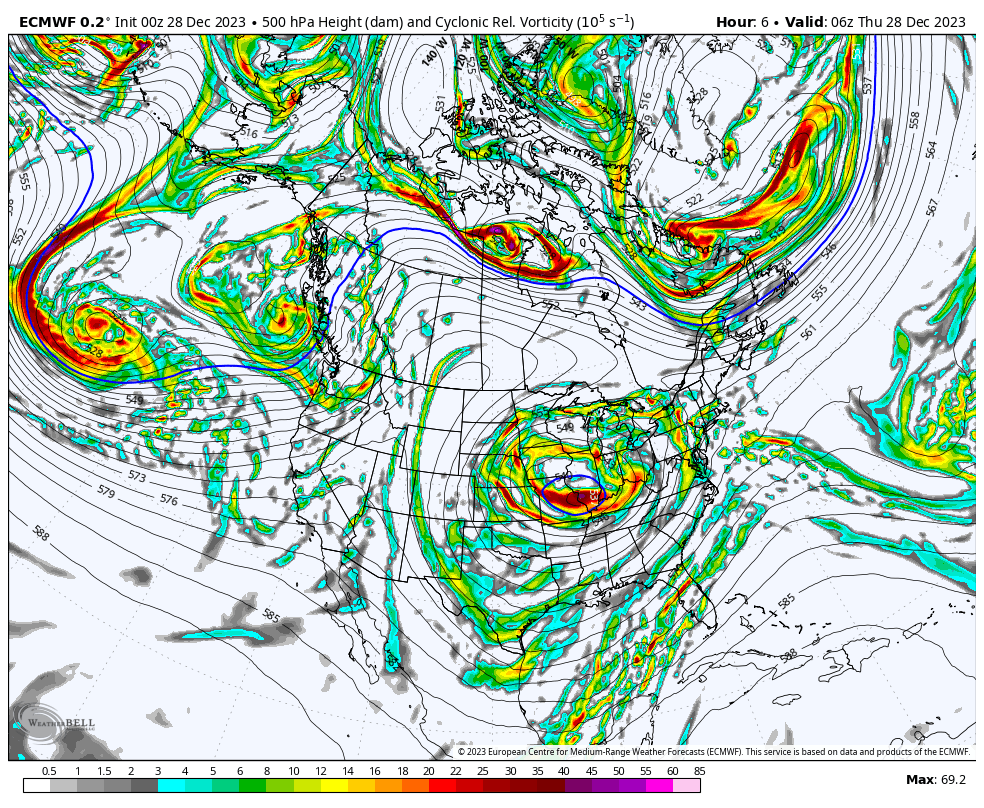
If you watch this loop of upper-level energy from start to finish at 7 PM Saturday and look specifically at that energy source over the NWT, its the driver that brings cold air into the state and determines the junky mix on the way. 
Picture
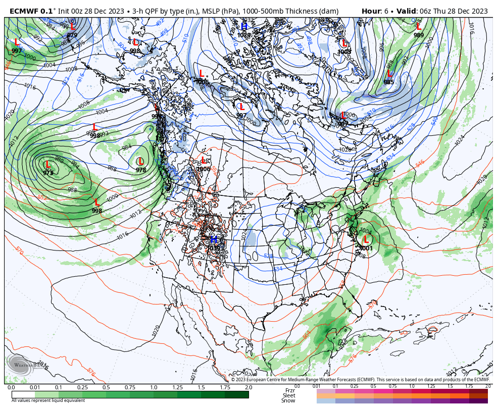
Looking at it from a forecast surface map point of view may be easier to understand. While there is so much emphasis on the surface maps, and justifiably so since that is the eventual outcome for people to deal with, our atmosphere operates from the top down.

At times the important upper-level energy sources that determine the outcome are over areas of the continent that have poor radiosonde (weather balloon) sampling. This causes guidance to be jumpy at times, and cases where there are significant changes in a short period of time. 

 I bring all of this to your attention as I see a strong ridge building in the west. The upper-level energy sources that will determine our weather will ride over the top of that. In a case like this where that energy over the NWT is racing toward our region in 36 hours, forecasts could shift in either direction of higher or lower impact. This is common in active winter patterns. Our pattern is about to become more active as we head into January. 

The outlook through Saturday

With the trough driving energy over the NWT holding the cold air card along with the recipe of a junk storm on the way, my confidence in how this is going to play out for precipitation types and amounts is on the low side.  How much ice and or sleet is going to factor in to how much snow comes out of it. The element of bust potential is fairly high looking at all of the ingredients in the bowl.
Picture
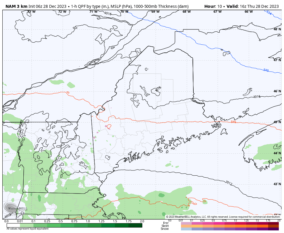
Thursday Noon to Saturday 2 PM -  Where confidence is good is the offshore storm tracking just south of Nova Scotia brings rain showers to the region through the day, and a bit of a breeze to the coast overnight into early Friday. Then confidence goes down heading into the overnight. 

The key to the flip to freezing rain will be the northeast wind shift that hauls cold air down from the north. How quickly the cold air bleeds in, how far south it goes, and when will determine how much ice accretes and when some areas of sleet work in. The convergence of cold and warm air at the low levels appears to battle it out through Friday. 

The cold air driver arrives Friday night. This is when the junk turns to snow as low pressure along the cold front passes through. Precipitation ends from west to east Saturday morning into the afternoon. 
Picture
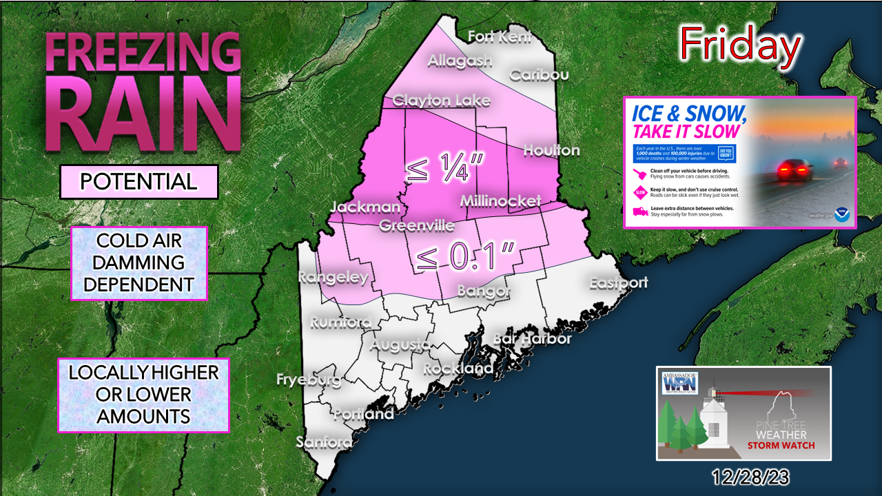
Outside of slippery roads and untreated surfaces, not a whole lot of ice to be concerned about. Again, where cold air damming sets up will determine how much accretion and for how long. Elevation plays a role in this to the west. Given the amount of liquid equivalent involved here, the accretion appears to be more annoying if anything. No concerns with power outages. 
Picture
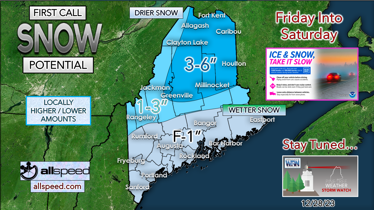
The snowfall amounts out of this appear to range from a few flakes in the south to upwards of 6" over the north. The arrival of the cold will dictate how much snow is produced from this. The quality of the snow isn't the greatest, and that may cut totals down over the west and the east. I expect that this idea will get tweaked, and I will update this on Friday. 

​Stay tuned. 

You are reading this as the result of the generosity
​of others before you who believe in the mission

Picture

Thank you to Allspeed Cyclery & Snow in Portland, Downeast Aerial Photography in Rockland, Dutch Elm Golf Club in Arundel,
and Sunrise Property Services in Bridgton, for partnering with Pine Tree Weather.

Special thanks to all the individuals who financially contribute.
​I sincerely appreciate your support. 


Stay updated, stay on alert, and stay safe!

- Mike

PRINT MEDIA: Feel free to quote and cite my work here for your stories. Please give me the professional courtesy of knowing that you are referencing my material so I can read your final product and acknowledge it on my media and link it on the Who I Am page here on the website. Feel free to send me a message via the Facebook page or Twitter (X) to get my phone number if necessary. Thank you! ​

​NOTE: The forecast information depicted on this platform is for general information purposes only for the public and is not designed or intended for commercial use. For those seeking pinpoint weather information for business operations, you should use a private sector source. For information about where to find commercial forecasters to assist your business, please message me and I will be happy to help you.

Comments
    Picture

    Mike Haggett
    Kennebunk, ME

    Weather-Ready Nation
    Ambassador

    Certified Weather
    Forecaster
    Penn State '21

    American Meteorological Society

    National Weather Association
    ​
    ​SKYWARN-CWOP

    Matthew 19:26


    Picture

    Jenna Gurtz
    Buffalo Grove, IL

    B.A. Atmospheric Science
    & Meteorology

    Campus Weather Service
    ​
    ​Penn State '25


    Picture

    Trey Austin
    Raleigh, NC

    Atmospheric Science 
    & Meteorology

    Environmental Science

    NC State '26


    Picture

    Harry Fuess
    East Lansing, MI

    Atmospheric
    ​& Climate Science

    Quantitative Data Analytics

    Michigan State '26


    Picture

    Daniel Weaver
    North Wales, PA

    Atmospheric Science 
    & Meteorology

    History

    Campus Weather Service

    ​Penn State '26


    DONATE

    Picture
    Picture
    Picture
    Picture
    Picture

    Picture

    Picture

    Picture

    Picture

    Picture

    Picture

    Picture

    Picture

    Picture

    Picture

    Picture

    Picture


    Archives

    June 2025
    May 2025
    April 2025
    March 2025
    February 2025
    January 2025
    December 2024
    November 2024
    October 2024
    September 2024
    August 2024
    July 2024
    June 2024
    May 2024
    April 2024
    March 2024
    February 2024
    January 2024
    December 2023
    November 2023
    October 2023
    September 2023
    August 2023
    July 2023
    June 2023
    May 2023
    April 2023
    March 2023
    February 2023
    January 2023
    December 2022
    November 2022
    October 2022
    September 2022
    August 2022
    July 2022
    June 2022
    May 2022
    April 2022
    March 2022
    February 2022
    January 2022
    December 2021
    November 2021
    October 2021
    September 2021
    August 2021
    July 2021
    June 2021
    May 2021
    April 2021
    March 2021
    February 2021
    January 2021
    December 2020
    November 2020
    October 2020
    September 2020
    August 2020
    July 2020
    June 2020
    May 2020
    April 2020
    March 2020
    February 2020
    January 2020
    December 2019
    November 2019
    October 2019
    September 2019
    August 2019
    July 2019
    June 2019
    May 2019
    April 2019
    March 2019
    February 2019
    January 2019
    December 2018
    November 2018
    October 2018
    September 2018
    August 2018
    July 2018
    June 2018
    May 2018
    April 2018
    March 2018
    February 2018
    January 2018
    December 2017
    November 2017
    October 2017

Proudly powered by Weebly