Keeping an eye on the Pacific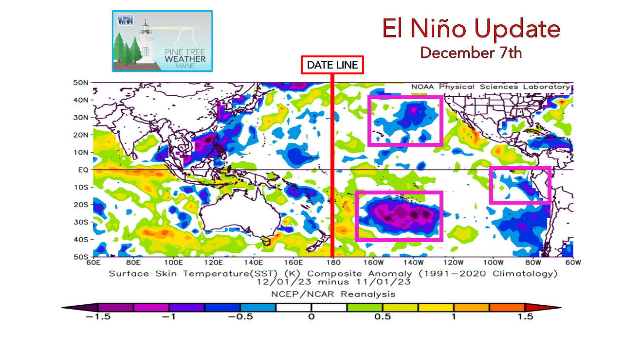 This makes my third update since the beginning of November on this. In my previous update a couple weeks back, I had mentioned something was odd in our pattern compared to other El Niño's and went under the hood to discover sea surface temperatures cooling offshore off Peru that began in August. Looking at it again, cooling has continued in that region in the past month. The cold pool in the south central Pacific has gained strength, and finally seeing a cool down in Gulf of Alaska region. These are good clues to help figure out how winter will unfold. 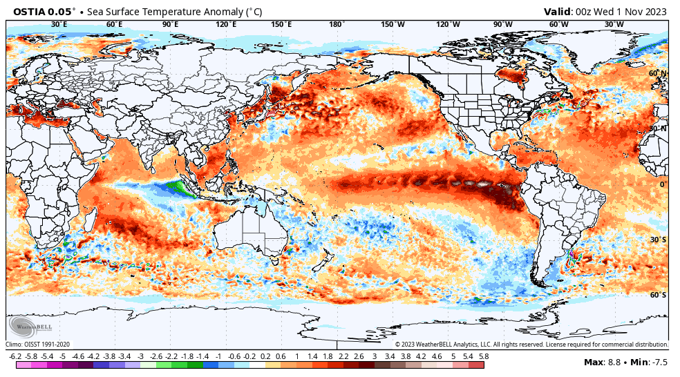 Anomalous sea surface temperatures compared to climatology from November 1st through Monday December 4th shows the cooling off Peru becoming more noticeable, along with the cooling to the north and south. Looking at the stream of equatorial warmth has weakened a bit but has also crawled more to the west. It's looking more and more like a Modoki El Niño as time continues. This Modoki El Niño isn't as strong as 2014-15. It's is opening up the door for the Madden-Julian Oscillation (MJO) over the western Pacific into the Indian Ocean to become more of a player. From what scuttlebutt I can pick up from folks far more gifted at analyzing all the ingredients in the atmospheric stew is that we're headed for a cold period settling in around the holidays and thus increased snow chances into January and February. We may have a good ol' fashioned winter for a change. It makes sense. We'll see if recent volcanic activity and what may come will play a role in all of this, too. For the sudden stratospheric warming geeks that follow, the idea of that has been pushed back to early January. So many gears run this engine. Sunday / Monday storm could be a corkerThis has been interesting to track all week. Confidence is good that an inside runner track is likely, which that jargon means a surface low tracks up through Quebec which puts Maine on the warmer side of it, and also potentially the windier side as well. At the onset, guidance had the system more to the east bringing more in the way of precipitation and less wind. That moved west earlier in the week, bringing more of a wind concern. With the storm within the five-day window, ideas are shifting eastward. Ah, the windshield wiper effect is alive and well. 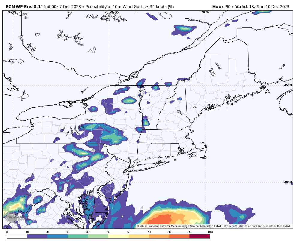 Sunday 1 PM to Tuesday 7 PM - This is the European ensemble mean of the percentage potential of tropical storm force wind gusts ≥ 34 knots (39 mph). The color scale indicates the orange and red are on the high end of confidence for this particular model suite. It's a fair bet coastal areas and higher elevations are likely to get the brunt of the wind, but in other areas of the interior aren't exempt, either. There have been ideas floating around that cold air damming may create an inversion cap that keeps the worst of the wind aloft, so impacts there are not clear as of yet. Knowing full well that folks have outdoor holiday decor in the spirit of the season, there isn't enough time to bet on that to happen. It will be important to secure anything that could become airborne between now and Saturday. With daylight at a minimum as we approach the winter solstice, if you need to get out and manage what you have going on with ample light, you should do so soon. Power outages are likely going to be an issue. Whether or not wind advisories or high wind watches or warnings will be issued will be determined in the next couple of days. With the signal as loud as this idea indicates, the time to prepare is now.  Liquid equivalent precipitation amounts are rising with the eastward shift. What was roughly 1" for the mountains has nudged closer to 2". One positive about the more easterly track is the cold may hold on longer at higher elevation, which would bring some amount of snow to help offset liquid. The ski hills are in their best snow condition at this point since 2018, which is good news given the dynamics of this storm. With a cool down on the way next week, ideas of snow for the following weekend being floated around, recovery should come fairly quick. We've seen worse wipe outs. Flood potential will be something to monitor, but at this point it is not of great concern. There is enough snowpack in the mountains to absorb a good portion of the rain. That said, there could be some localized from runoff as temperatures climb into the 40s and ripen it. This is one of the finer details to be worked out. 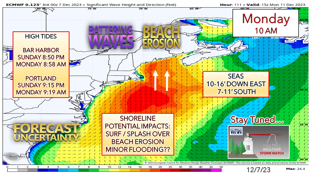 The shorelines could be up for a beating, especially to the east of Portland out of the shadow of Cape Cod. We're heading toward a new moon (Tuesday) which brings astronomical tides up, with Monday morning high the most elevated. Depending on storm maturity, track, timing. and pressure will dictate how this plays out. I am not sure of the flooding potential at this point, but with the surf forecast, I can't see where low-lying areas in MidCoast and DownEast areas escape without some. I will update on this Friday morning. Please make my 2 AM wake up calls worth it |

Mike Haggett
|