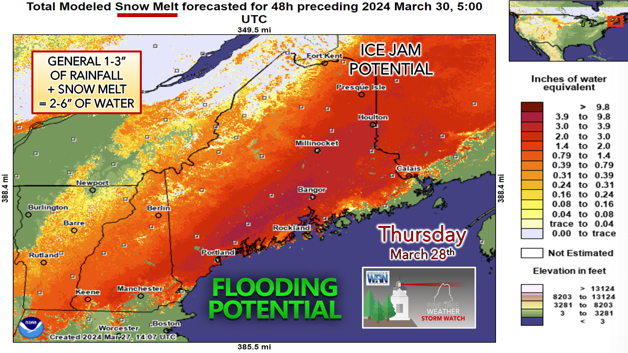
Rain, snow, and wind on the wayFLOOD POTENTIAL… While I do not believe this will be an extreme event, I expect areas where it could be problematic. River rises are expected. The ideas pitched by the Northeast River Forecast Center have several rivers predicted to hit the action stage or minor flood levels. As I have said for the past couple of days, the snowpack over the interior should absorb a decent amount of rain, but there will be runoff given the extended period of dew points above 32° and fog that will eat away at it. WHILE WESTERN AND NORTHERN AREAS ARE NOT UNDER FLOOD WATCH, THAT DOES NOT MEAN FLOODING WON’T OCCUR. The ground is frozen, and the liquid goes somewhere: brooks, streams, rivers, gullies, backyards, ditches, and/or basements. An ice jam potential is there for the Saint John River.
Depending on how this plays out, ADDITIONAL FLOOD STATEMENTS AND BULLETINS MAY BE ISSUED. There is still some wiggle room. Heavy rain moves through the area overnight into Friday morning. BACKSIDE SNOW… The area of low pressure forming along the stalled boundary is expected to amplify on its way to the Gulf of St. Lawrence on Friday. Confidence is increasing that higher elevations and The County could pick up as much as 6” of snow as cooler air wraps in on the backside a bit earlier than previous ideas. This is likely to be a sloppy pasting for the most part. A solid coating as far south as the interior MidCoast, Bangor, could be on over to Washington County areas Friday morning. WIND… Depending on how much snow sticks to trees and lines, areas that receive a solid layer of snow as a parting gift may experience power outages. Isolated outages are possible everywhere as wind gusts crank between 30-40 mph, with 40-55 mph potential for the higher terrain. WIND CHILL returns Saturday morning, making it feel like January with single digits and low teens for the mountains and north and upper teens to low 20s for the south and east. The fan on the air conditioner gradually reduces speed on Saturday. It temporarily shuts down heading into Easter morning before increasing in the afternoon in the wake of a weak wave that passes through. EXTENDED OUTLOOK… While the annual April Fools storm may not happen on the day itself, there is potential for an impactful snow event toward the middle part of next week. Looking at the steering level and temperatures, I do find the setup favorable, with a nice block setting up over Greenland. Given the assortment of ideas out there, it’s too early to get into details beyond that, but it is something to stay mindful of and updated on. As always, I appreciate your readership and financial support! – Mike |
Mike Haggett
|


