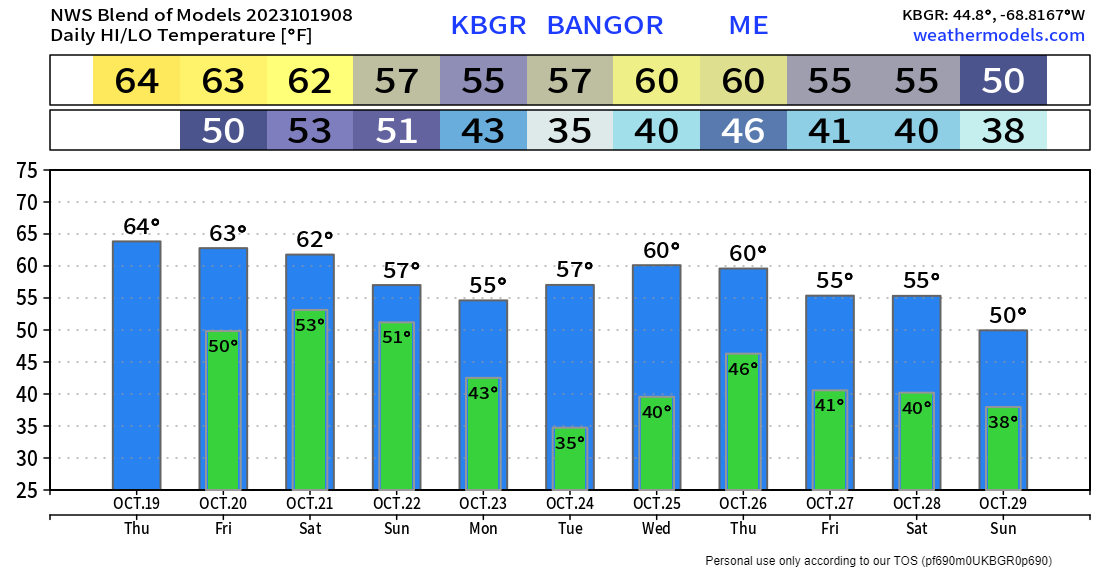
Pine Tree Weather
  • DISCUSSIONS
  • DONATE
  • WEATHER WALL
  • MAPS
  • RAIN OUTLOOK
  • SEVERE
  • MARINE
  • CPC OUTLOOK
  • Kennebunk
  • MY BIO
  • PTW IN MEDIA
  • OBSERVING WEATHER
  • INTERNSHIPS
  • INTERN ALUMNI
  • DISCUSSIONS
  • DONATE
  • WEATHER WALL
  • MAPS
  • RAIN OUTLOOK
  • SEVERE
  • MARINE
  • CPC OUTLOOK
  • Kennebunk
  • MY BIO
  • PTW IN MEDIA
  • OBSERVING WEATHER
  • INTERNSHIPS
  • INTERN ALUMNI

Thursday October 19, 2023

10/19/2023

Comments


A wet weekend ahead

Picture
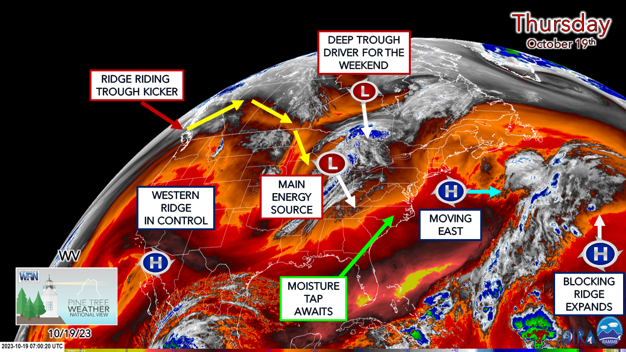
The low-level water vapor image from 3 AM shows all the players on the table. The key piece that is causing some level of uncertainty is the trough kicker that is entering British Columbia. The models have not had a good handle on it given the fact that it is in a dead zone where weather balloons can't sample it to get a read on it. That changes today. By Friday morning, there will be better data and the forecast will come into line. 
Picture
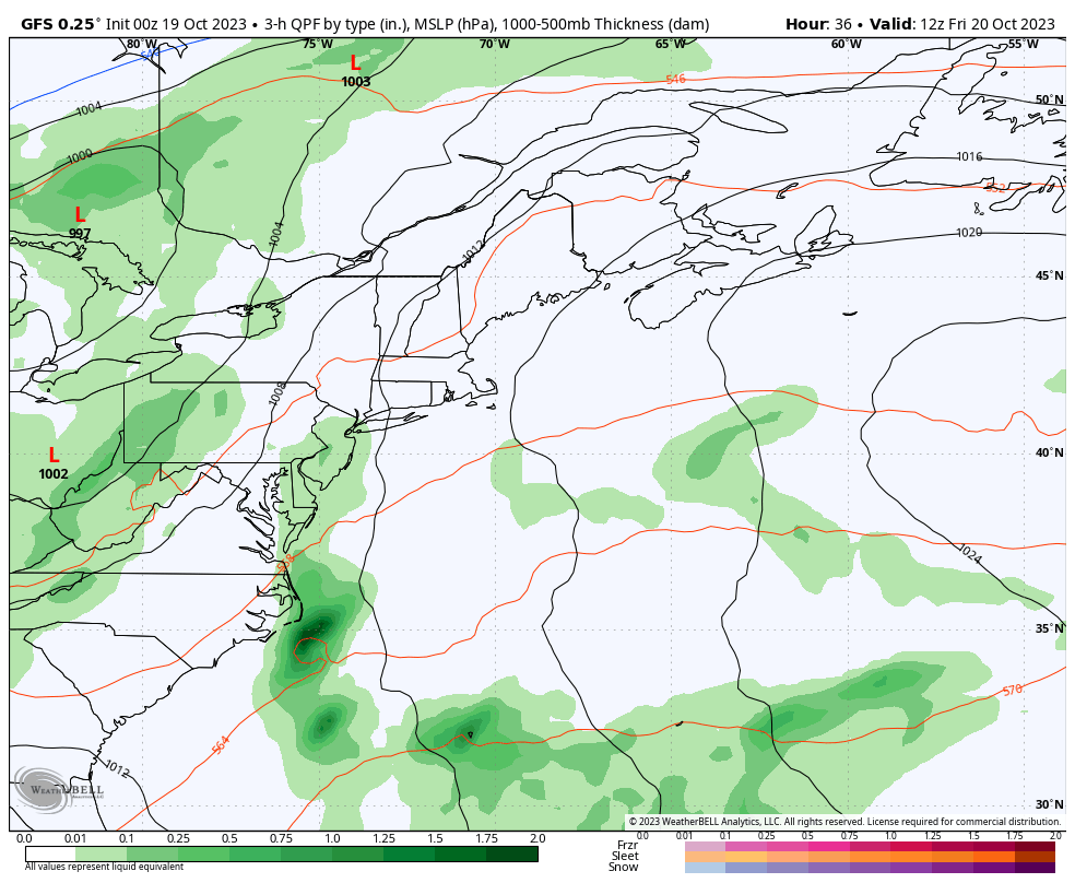
Friday 8 AM to Monday 8 AM - While forecast uncertainty remains, the ideas of the phasing of the polar jet and the subtropical jet appear to be too late for a storm of significance to generate over the region. That is a different story for Atlantic Canada as they are likely to get a decent storm. With the phasing well offshore, that cuts down on the rain amounts over Maine to a certain extent. Rain begins over southwestern areas Friday afternoon which will overspread the region overnight and continue with various intensities through the day. The uncertainty comes in for Sunday. The ideas are out there of an inverted trough set up as the GFS model here depicts which could keep the rain going and may bring snow to the higher hilltops as cold air gets injected into it. 

Since this setup is more disturbance oriented given the late phase and residual upper-level energy tracking along a slow-moving surface boundary, there is a certain amount of bust potential that comes into play. There could be an issue with dry slots in between which may decrease rain amounts. Pending on how the lead low decays and transfers energy to the disturbances generated in its wake could cause overperformance, and the inverted trough may enhance that. 
Picture
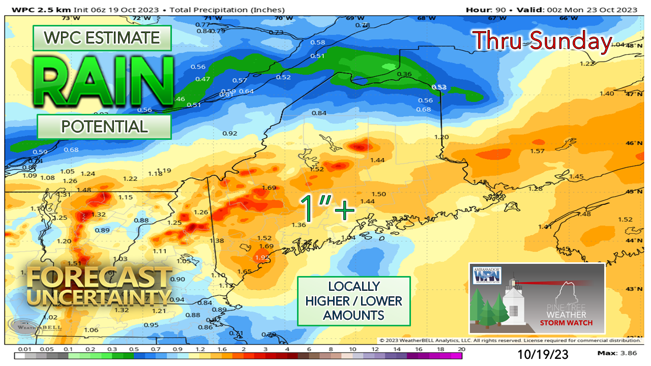
The jury is still out in my mind on how much rainfall will come out of this for the reasons mentioned. The over / under of roughly 1" is a reasonable expectation. Individual ensemble ideas are still running around a 50/50 split between more and less. 

The ideas on wind appear manageable. I am not so concerned about wind on the front side of the system Friday into Saturday as there could be some gusts in the 20-30 mph range. Pending on how the trailing disturbances interact and siphon off energy from one another, gusts could increase on Sunday for the mountains in the 30-40 mph range with 20-30 mph elsewhere as the northwest wind increases. 

Great bikes, food, drink, and music in Portland
​rain or shine on Saturday

Picture
Allspeed Cyclery and Snow is a proud partner of Pine Tree Weather. Next Saturday they are having their annual rider appreciation day to benefit the Falmouth Land Trust. You can demo high quality bikes, ride around Greater Portland, participate in a raffle where a brand-new Santa Cruz Chameleon and other prizes are involved. Orono Brewing will be on hand for adult beverages, along with the Sal de la Tierra Mexican food truck, and Bluegrass music by Jerks of Grass. For more information, please check out their Facebook page. ​

Frost possible everywhere Tuesday morning

Picture
The National Weather Service is pulling the plug on the frost / freeze program on Saturday until spring. For those who have their mums going and other late season growing, you are on your own to manage the covering and/or bringing in the plants going forward. It's a fair bet that Tuesday morning that most areas away from the immediate shorelines will have frost. 

The outlook for next week appears unsettled from Thursday onward. A cool down is expected heading into early November. 

It's that time of year again... 

Picture
The SKYWARN spotter program was developed in the early 1970's to train amateur weather enthusiasts to pass along observations of interest and importance to the National Weather Service. What started off as a group of HAM radio operators has evolved over time to an advanced network thanks to the evolution of communication.

Through reports from trained sets of eyeballs, NWS can monitor current storm progress and pass along critical information to the public in the form of bulletins based on information it receives from trained spotters. After the storm, precipitation and damage reports are analyzed for forecast verification purposes and improvements. 

What the NWS is looking for is precipitation amounts and types, along with storm related damage, whether by flooding, wind, lightning, tornado, heavy snow, and/or ice accretion.

Filing storm reports can be done easily and quickly in many ways through local office websites, social media, email, and telephone. 

The cost and training are FREE. You do not have to be meteorologically savvy to become a trained spotter. All that is needed is a causal interest in weather and a desire to learn more about it. The seminars are fast paced with a lot of information, along with items you may not have been aware of. 

This is the WINTER weather seminar. If you participated in the SPRING seminar, you should attend this one to be fully trained. If you are a current spotter and have not done one of these in the past three years, you should sign up for a refresher. 

For training through NWS Caribou (Aroostook, Hancock, Piscataquis, Penobscot, Northern Somerset, and Washington Counties), please click on the following dates to register:

Thursday, October 26th from 6 - 7:15 PM

Wednesday, November 8th from 6 - 7:15 PM

Wednesday, November 15th from 6 - 7:15 PM

Friday, November 17th from 6 - 7:15 PM


For more information, please check out the NWS Caribou SKYWARN page.

For training through NWS Gray (Androscoggin, Cumberland, Franklin, Kennebec, Knox, Lincoln, Oxford, central and southern Somerset, Waldo, and York Counties along with ALL of New Hampshire), please click on the following dates to register:

Thursday, October 26th from 6 - 7:30 PM

Monday, November 13 from 6 - 7:30 PM


NWS Gray is also offering a special COASTAL FLOOD spotter training seminar 

Wednesday November 15th from 6 - 7:30 PM

This was well attended last fall. I know a few of you missed it last year that wanted to participate, so here is your chance. 

For more information, please check out the NWS Gray SKYWARN page.

NOTE: If for some reason you cannot attend a spotter training session that is listed for the county you live in by the weather office that serves your area, go ahead and register the time offered with the office outside of your area. There will be an internal transfer of information of your attendance, and your spotter ID issued by your local office and sent via email within a couple of weeks after the session. ​

​​I need your financial support to continue into 2024

Picture

Thank you for your years of readership and for your financial support. It is because of your funding that this operation continues.

I will be away on vacation from October 21st to October 28th resuming updates around Halloween.

Stay updated, stay on alert, and stay safe!

- Mike

​​NOTE: The forecast information depicted on this platform is for general information purposes only for the public and is not designed or intended for commercial use. For those seeking pinpoint weather information for business operations, you should use a private sector source. For information about where to find commercial forecasters to assist your business, please message me and I will be happy to help you.

Comments
    Picture

    Mike Haggett
    Kennebunk, ME

    Weather-Ready Nation
    Ambassador

    Certified Weather
    Forecaster
    Penn State '21

    American Meteorological Society

    National Weather Association
    ​
    ​SKYWARN-CWOP

    Matthew 19:26


    DONATE

    Picture
    Picture
    Picture
    Picture
    Picture

    Picture

    Picture

    Picture

    Picture

    Picture

    Picture

    Picture

    Picture

    Picture

    Picture

    Picture

    Picture


    Archives

    April 2025
    March 2025
    February 2025
    January 2025
    December 2024
    November 2024
    October 2024
    September 2024
    August 2024
    July 2024
    June 2024
    May 2024
    April 2024
    March 2024
    February 2024
    January 2024
    December 2023
    November 2023
    October 2023
    September 2023
    August 2023
    July 2023
    June 2023
    May 2023
    April 2023
    March 2023
    February 2023
    January 2023
    December 2022
    November 2022
    October 2022
    September 2022
    August 2022
    July 2022
    June 2022
    May 2022
    April 2022
    March 2022
    February 2022
    January 2022
    December 2021
    November 2021
    October 2021
    September 2021
    August 2021
    July 2021
    June 2021
    May 2021
    April 2021
    March 2021
    February 2021
    January 2021
    December 2020
    November 2020
    October 2020
    September 2020
    August 2020
    July 2020
    June 2020
    May 2020
    April 2020
    March 2020
    February 2020
    January 2020
    December 2019
    November 2019
    October 2019
    September 2019
    August 2019
    July 2019
    June 2019
    May 2019
    April 2019
    March 2019
    February 2019
    January 2019
    December 2018
    November 2018
    October 2018
    September 2018
    August 2018
    July 2018
    June 2018
    May 2018
    April 2018
    March 2018
    February 2018
    January 2018
    December 2017
    November 2017
    October 2017

Proudly powered by Weebly