|
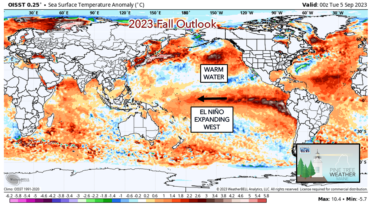
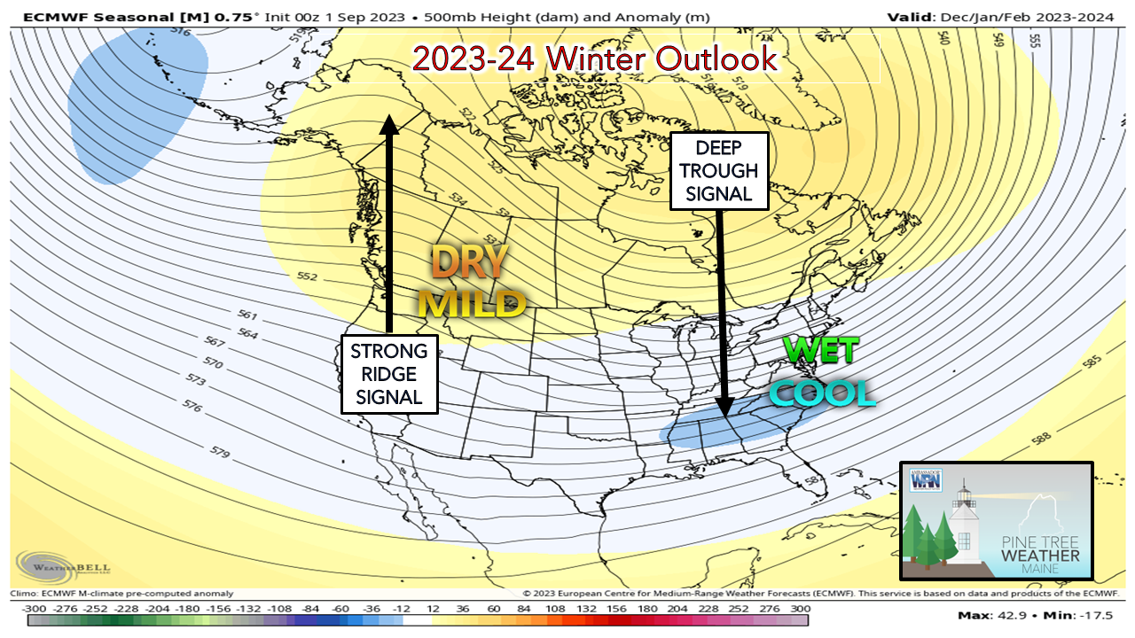
Over the past couple of weeks, I've been asked about my thoughts on fall and winter. Over the years I've had a cynical view of seasonal outlooks. There are so many variables that go on over the course of a three-month period that cause forecasts to bust with temperature and precipitation. I've said for years that these seasonal outlooks are based on meteorological voodoo, meaning there are certain points in weather patterns picked out to present a theory. That is the bottom line here, it is simply an idea. Much of seasonal forecasting is based the emphasis on the ENSO (El Niño Southern Oscillation) index. There is no question that what goes on equatorial has an impact on what happens in the mid latitudes, but it is not the only thing forecasters need to stay mindful of. Reading the tea leavesLooking at the sea surface temperature anomaly indicates El Niño's rapid growth since March, and indications are there that it may not be done yet. The relatively calm westerly trade winds along the equator off the South American coast have allowed the ocean temperatures to warm and expand. The question at this point is how far west it will expand and for how long. Note the warm water south of Alaska. This is a key feature that amplifies the strong ridging that has gone on over the west all summer and will play a role in the winter as well. The meteorological fall outlook from the CFS indicates El Niño's expansion may be halted a bit due to typical typhoon activity. We'll see what this looks like as the fall progresses. There is a wildcard sub feature that goes on along with the ENSO that has impacts on its outcome and that is known as the Madden-Julian Oscillation (MJO). The MJO is a 30-day pattern over the western Pacific into the Indian Ocean. The MJO has the ability to enhance or neutralize El Niño over time with convective, monsoonal activity or the lack thereof pending on intensity. The eastward propagation of moisture into the westerly trade winds and where the upper-level divergence sets up has a ripple effect on cold air at the north pole and can set off a sudden stratospheric warming event. A great read on this is here: What is the MJO, and why do we care? Some ideas are floating around that this could be one of the stronger El Niño's based on outlook. Before snow lovers begin to lick their chops of a bountiful supply of frozen goodness, please understand that a strong El Niño may not be your friend. In years where the ONI was greater than 1.5, most snowfall amounts were below normal. For Portland, 1991-92 (58.6"), 1997-98 (54.5"), and 2015-16 (51.8") versus the seasonal average of 64.9". For Caribou, 1991-92 (94.0"), 2015-16 (94.8") versus the seasonal average of 120.1" with 1997-98 (124.5") the exception that finished just above the norm. Important to note here that us long timers remember what happened in January 1998 with the devastating ice storm. I am not saying that it is going to happen, as freezing rain is about as difficult to forecast as your fantasy football team, but it is a part of the history here. Looking at the ideas presented in the long-term outlooks, the chances are good that winter will be delayed in starting, which has been the pattern in recent years. Fall appears wet and on the warm side, but as I have been saying since early August, an early frost threat is there. The overall pattern of strong ridging over the west and troughing over the east continues to be the theme that we have seen with regularity since June. The idea of the deep trough over the south is an indicator as to how strong the El Niño could potentially be. I don't expect winter to kick into high gear until January, and if the long-term ideas are correct, February could be interesting, as it usually is. Late season snow is certainly in cards along with a delayed start to spring. This may be one of the colder winters we've experienced in recent years, or at least, have a better chance for cold shots. Pine Tree Weather is funded from followers like you. I would appreciate your financial support. Click here for how you can contribute. You may not like the weather, but I hope you like what I do, and support my efforts. Thank you! Stay updated, stay on alert, and stay safe! - Mike NOTE: The forecast information depicted on this platform is for general information purposes only for the public and is not designed or intended for commercial use. For those seeking pinpoint weather information for business operations, you should use a private sector source. For information about where to find commercial forecasters to assist your business, please message me and I will be happy to help you. |
Mike Haggett
|


