Pine Tree Weather
  • DISCUSSIONS
  • DONATE
  • MAPS
  • NWS BRIEFINGS
  • SATRAD
  • MARINE
  • SNOW / ICE OUTLOOK
  • RAIN OUTLOOK
  • CPC OUTLOOK
  • Kennebunk
  • OBSERVING WEATHER
  • Who We Are
  • My Photography
  • DISCUSSIONS
  • DONATE
  • MAPS
  • NWS BRIEFINGS
  • SATRAD
  • MARINE
  • SNOW / ICE OUTLOOK
  • RAIN OUTLOOK
  • CPC OUTLOOK
  • Kennebunk
  • OBSERVING WEATHER
  • Who We Are
  • My Photography

Triple flood threat for the region through Monday, at least

4/18/2019

Comments


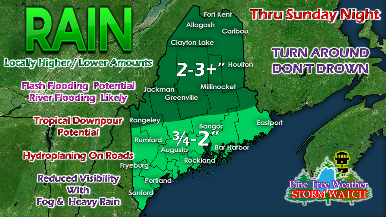
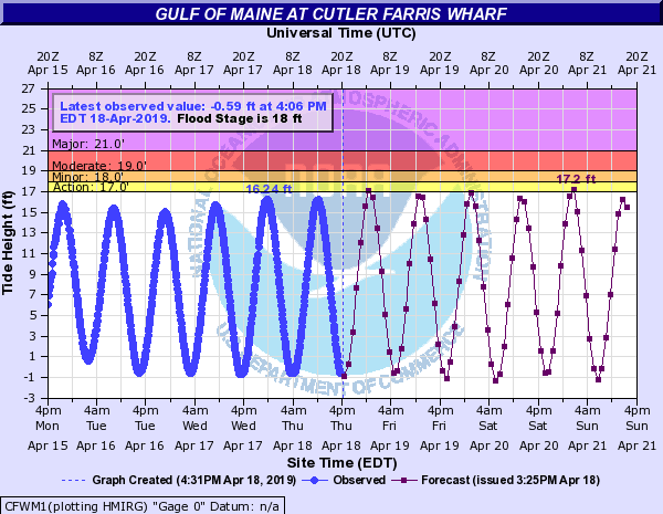
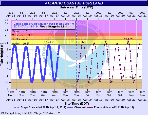
Plenty of water in the snow pack to be released

Picture
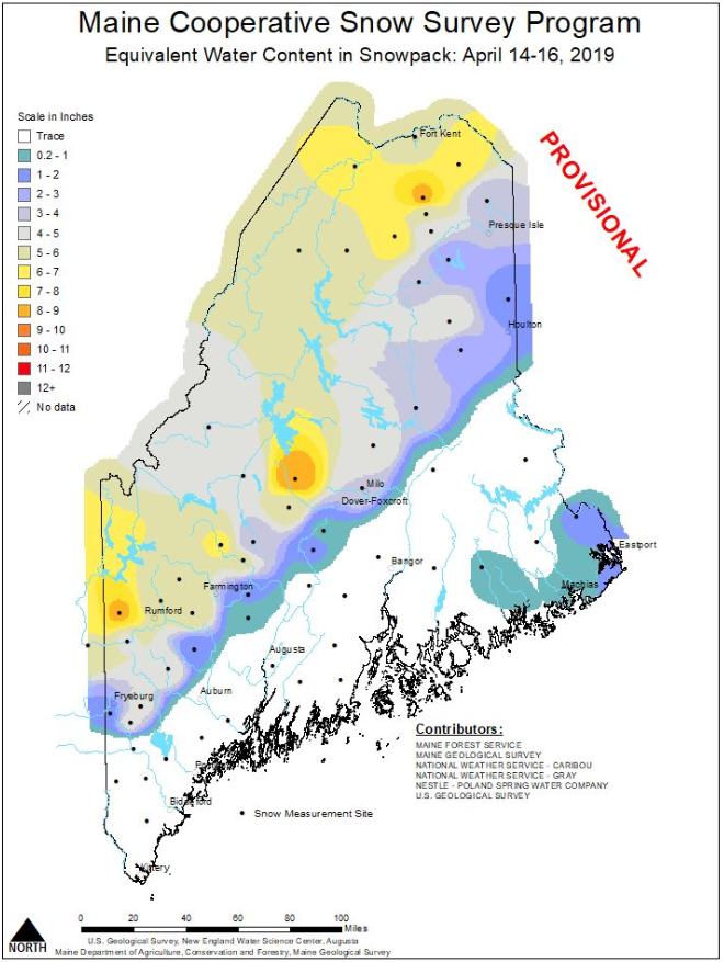
As the graphic indicates, this is the amount of water contained within the snow that is on the ground from a survey done this past Sunday through Tuesday. Much of the western mountains and northern areas of the state have 4-9" of water waiting to be released from its frozen condition. While this event may not eliminate it in its entirety, I suspect this graphic to look less ominous by this time next week. 

Along with river flooding, comes
potential for flash flooding

Picture
Northern areas see the heavy rain Friday afternoon into the night. The rest of the region sees the heavy rain Friday night into Saturday. Showers are likely to continue into Sunday, perhaps Monday morning. 
Picture
With long wave frontal boundaries comes tropical moisture. With that tropical moisture comes the threat of downpours and thunderstorms. In one scenario, thunderstorms over frozen areas could lead to rapid melting, fast rising brooks, streams and rivers that could cause ice jams. Another scenario is that the ground may be clear of snow, but downpours and thunderstorms could cause flash flooding due to the nature of them. 

There is no question that the areas with snow cover and iced up tributaries could see the greater affects with what is coming. Folks down stream along the coast will see the rivers rise as well, likely as we head into next week.   ​

Then there is the coastal threat

Picture
Tides are astronomically high through the weekend due to the full moon. One key feature to this frontal boundary is that the wind direction will be onshore from the south until the storm passes late weekend. Under those conditions, ocean water will be pushed toward the coast. ​
Picture
Important to note, the highest tides are in the wee hours of Saturday and Sunday morning. At this point, what flooding occurs is appears to be minor. Expect splash over and some beach erosion in the low lying areas.

Regional outlook through Tuesday

Picture
After the weekend is over, the best chance for sun appears to be in northern areas to start next week. The rest of the region may have to deal with some shower activity, pending on a cold front passing through on Monday, and a potential ocean low for Tuesday. Confidence beyond Sunday is low at this point. 

► ► For the latest official forecasts, bulletins and advisories, please check in with the National Weather Service in Gray for western and southern areas, or Caribou for northern and eastern parts of Maine.

► ► Your financial donations are much appreciated to keep this site funded and for further development. 

I sincerely appreciate your support not only financially, but also in sharing my efforts with others.

Always stay weather aware! 

​- Mike

Comments
    Picture

    Mike Haggett
    Kennebunk, ME

    Certified Weather
    Forecaster
    Penn State '21

    American Meteorological Society

    National Weather Association

    Weather-Ready Nation 
    Ambassador
    ​
    ​SKYWARN-CWOP

    Matthew 19:26


    Support
    Pine Tree Weather

    DONATE

    Picture

    Picture

    Picture

    Picture

    Picture

    Picture

    Picture

    Picture

    Picture

    Picture

    Archives

    January 2023
    December 2022
    November 2022
    October 2022
    September 2022
    August 2022
    July 2022
    June 2022
    May 2022
    April 2022
    March 2022
    February 2022
    January 2022
    December 2021
    November 2021
    October 2021
    September 2021
    August 2021
    July 2021
    June 2021
    May 2021
    April 2021
    March 2021
    February 2021
    January 2021
    December 2020
    November 2020
    October 2020
    September 2020
    August 2020
    July 2020
    June 2020
    May 2020
    April 2020
    March 2020
    February 2020
    January 2020
    December 2019
    November 2019
    October 2019
    September 2019
    August 2019
    July 2019
    June 2019
    May 2019
    April 2019
    March 2019
    February 2019
    January 2019
    December 2018
    November 2018
    October 2018
    September 2018
    August 2018
    July 2018
    June 2018
    May 2018
    April 2018
    March 2018
    February 2018
    January 2018
    December 2017
    November 2017
    October 2017

    RSS Feed

Proudly powered by Weebly