
Cold front makes a painfully slow approach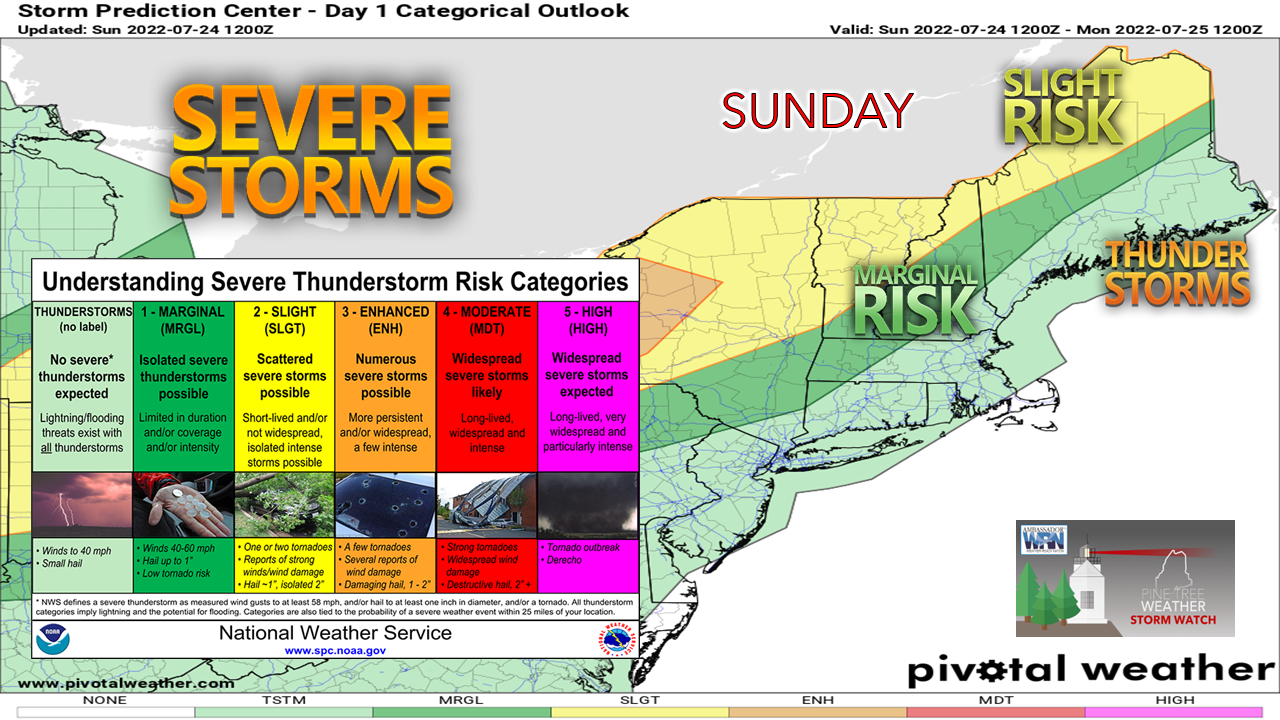 For those who are experiencing the beauty and peace of the mountains, north woods, and The County, it may get a bit rough Sunday afternoon into the evening. A cold front is crawling at a snail's pace across Ontario and Quebec toward our region. This is allowing for more heat and humidity to build into the area, which is providing more fuel for strong to severe storms. 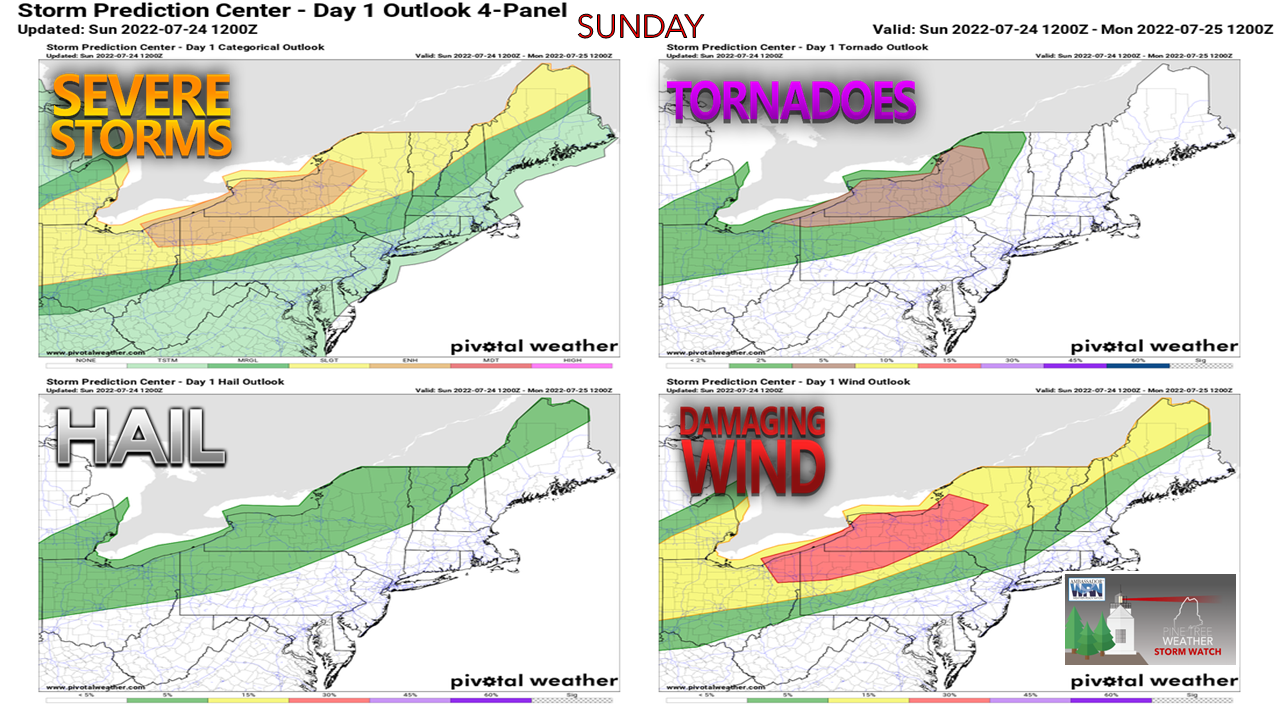 The greatest risk through Sunday evening is for the mountains and north. For those located south of that region, it would be wise to pay attention to the sky. With a strong southerly flow developing, I can totally envision the risk of storms firing along the sea breeze boundary which could bring a surprise to those finding relief at lakeside beach or swimming hole. Damaging wind is the main concern with the strong to severe storms that develop. With the atmosphere putridly saturated, torrential rain is possible which could cause flash flooding. There is also the risk of hail with any discrete cells that develop.  Sunday 1 PM to Monday 1 AM - As the cold front approaches, showers and storms begin to fire. It's a timing game for severe potential. If the cold front becomes what is known as "quasi-stationary" over the St. Lawrence River valley, which in that scenario would keep the bulk of the severe threat in Quebec, which is the idea the 2 AM (06z) HRRR idea suggests. If I am in Rangeley, Jackman, Greenville, Baxter and on up through Presque Isle and north and west of there, I am paying close attention as the front may be able to move closer to the Quebec border and thus increase the threat. As the front slowly crawls closer to the state Sunday night, loss of daytime heating quells the severe threat somewhat, the vulgar overnight lows in the mid to upper 70s along with dew points in the low 70s keeps the threat of storms possible into the overnight. 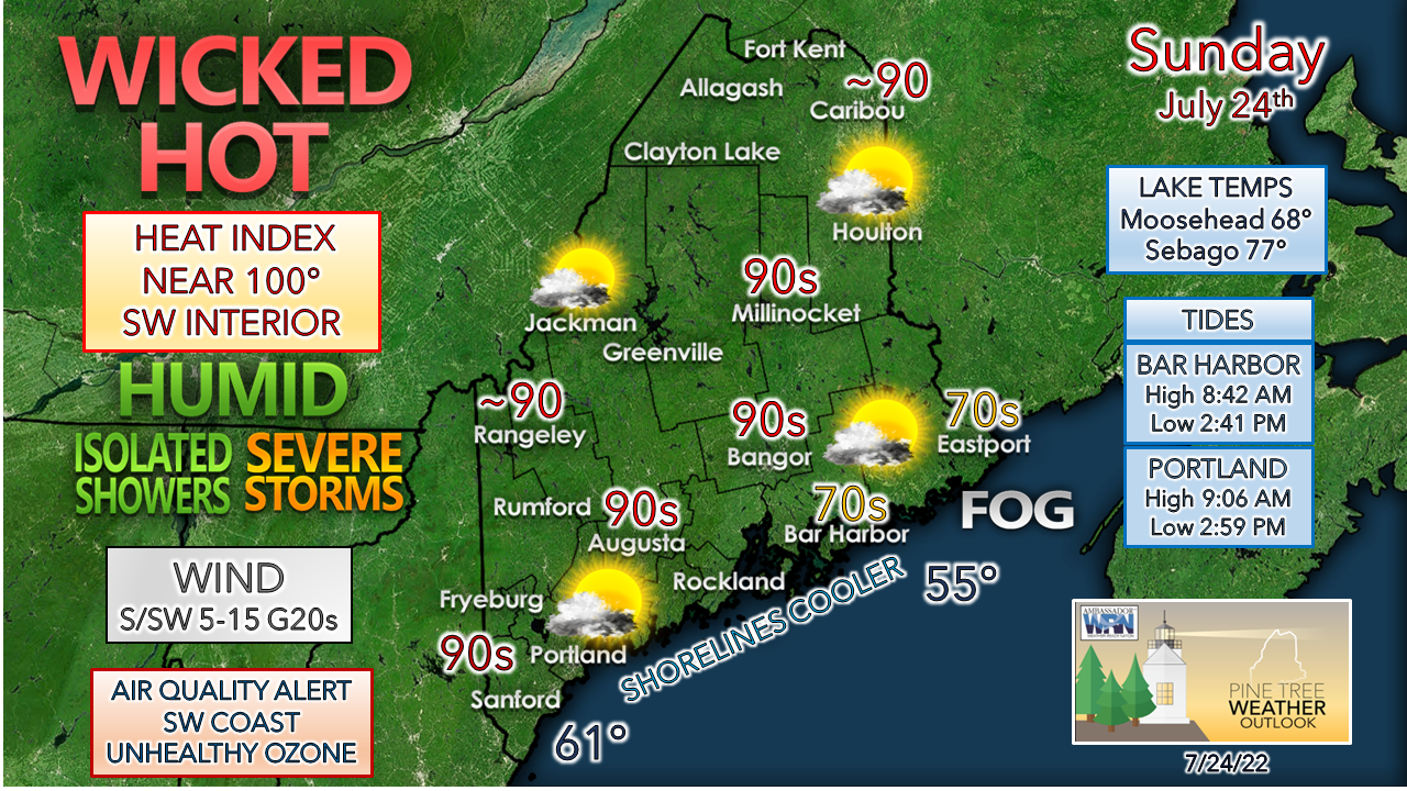 For those desperate for relief, the DownEast shorelines is where to go for the day. The shorelines between Bar Harbor and Eastport may be buried in fog for a good portion, if not all day. The seaside beaches and harbor towns are likely to be jammed by relief seekers. Once again there will be plenty of space at the beaches with the mid-afternoon low tide. Expect a stronger breeze there. A word to the wise... don't mess with this heat. On a personal note, I cancelled my early tee time on the golf course as I don't deal with humidity and poor air quality at all. It's not often I do that. Stay cool, stay hydrated, stay mindful of the heat stroke potential.  Overnight showers and storms set the table for Monday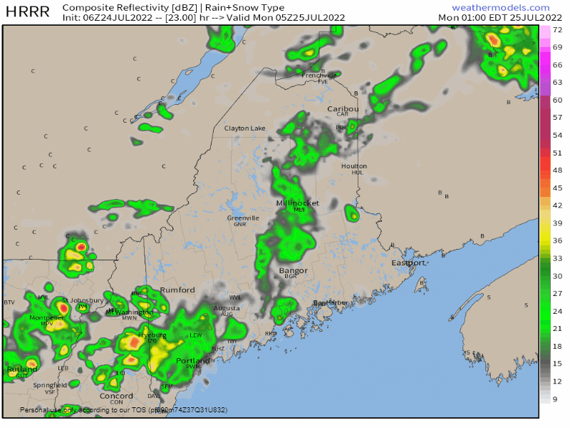 Monday 1 AM to 1 PM - Overnight lows could set records with many areas bottoming out in the 70s with dew points in the low 70s. For those without air conditioning, this is vile. To add insult to injury, showers are possible with the chance for thunder, which means windows should be closed or left at a low level to avoid electric fire from the box fan. The showers that roll through the region in the morning hours of Monday set the stage for storm potential Monday afternoon. Conditional severe threat Monday afternoon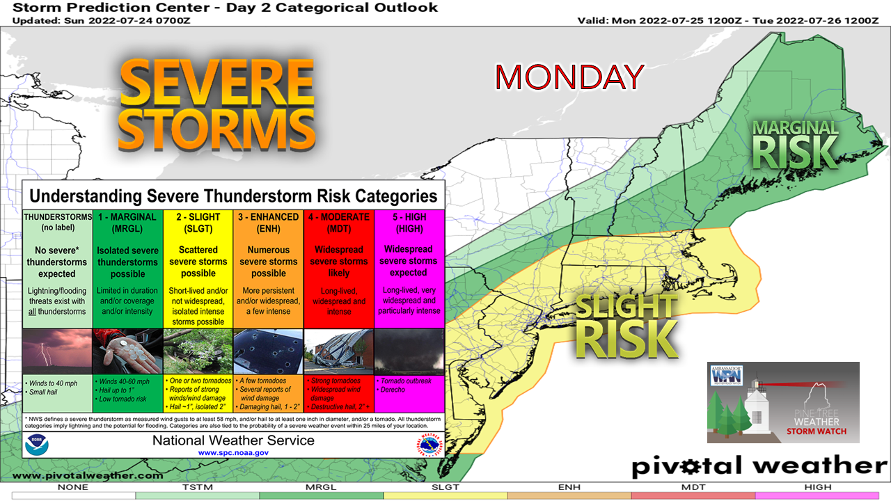 Cloud debris associated with any occurring showers and storms Monday morning could impact the outcome of the severe threat Monday afternoon. The benefit of the cloud debris is the temperatures are expected to be cooler than Sunday. While cooler, the offensive dew point levels in the low to mid-70s may not make it feel any cooler, and it continues the poor air quality levels. 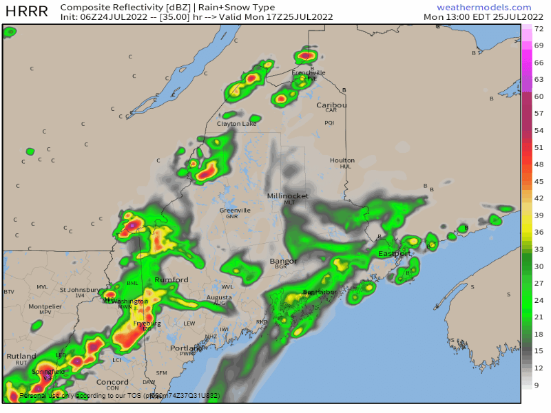 Monday 1 PM to Tuesday Midnight - If the sun gets out Monday afternoon, look out. The HRRR idea indicates that idea has potential. Given the amount of high-octane fuel around thanks to the nauseating level of humidity, it won't take much sun to drive temperatures up and ignite supercell potential. Damaging wind and torrential rain from flash flooding, along with potential for large hail is a distinct possibility here. Storms could train and backfill, keeping the threat going. Again, this is cloud dependent and a wait and see situation. After the storms pass and the front moves offshore, temperatures and dew point levels begin to drop. Folks living in the coastal plain can expect one more humid night before relief comes on Tuesday. For the mountains and north, expect to be able to open the windows and get a good nights sleep. Outlook through FridayThe region dries out on Tuesday. A shortwave front approaches from the west on Wednesday which raises the heat and humidity upward a bit Wednesday and brings the risk of showers and storms into Thursday. Another shortwave front approaches the region Thursday night and brings the chance for another round of showers and storms on Friday. 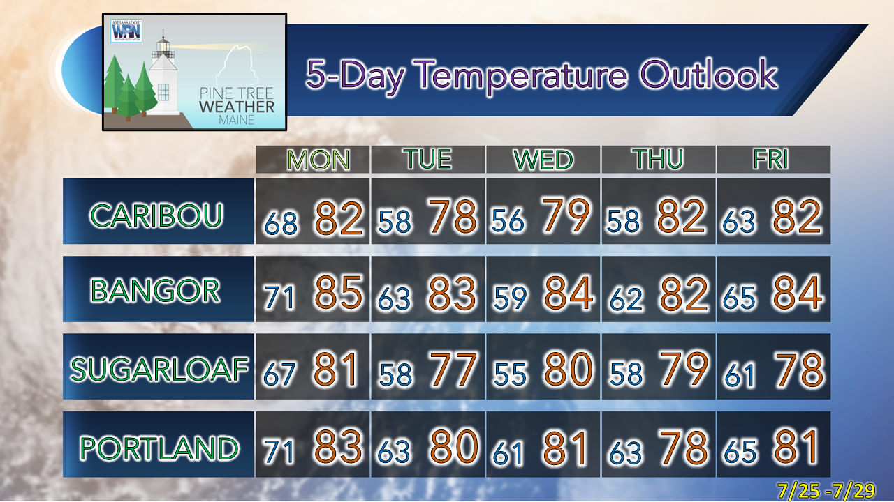 Thank you for supporting this community-based weather information source which operates by financial contributions from people like you. Stay updated, stay on alert, and stay safe! NEXT UPDATE: MONDAY - Mike NOTE: The forecast information depicted on this platform is for general information purposes only for the public and is not designed or intended for commercial use. For those seeking pinpoint weather information for business operations, you should use a private sector source. For information about where to find commercial forecasters to assist your business, please message me and I will be happy to help you. |

Mike Haggett
|


