
Four of the next five days look good Outside of some showers and storms possible on Thursday, the pattern is dry overall over the next few days. After another uptick of heat and humidity, below normal temperatures arrive for the weekend. Do we even remember what below normal is after the summer we've had? Have a hot beverage and a chamois shirt handy... One more round of tropical humidity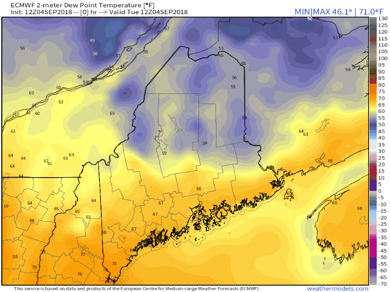 While the recent round of tropical air has departed from the region, it hasn't gone very far. The ridge responsible for it will return starting Tuesday night into Wednesday, and then depart Thursday as a cold front sweeps through from the northwest. With the pattern changing, this may be the last day of the oppressive humdity (70°+ dew point) the region will see until next year. That said, the chances muggy weather (65° dew point) may not be over for a while yet. For those that can't read the fine print, those are 30° dew points (or less) at the tail end of the loop, and that is on the way for the weekend. Let's have an honest talk about the tropics Now that tropical storm season is showing signs of activity, the craziness of social media has increased along with it. I joked about lawn darts on my Twitter feed this morning when it comes to operational forecasts (think the red dart in the circle) and ensemble member forecasts (think the blue darts surrounding the red one). Consider this a "How To Survive Tropical Season Hysteria Guide" so you don't get caught up in the hype and pass along misinformation to the rest of your friends and followers. Let's take a look at the European operational model run from 12z (8 AM) Sunday... 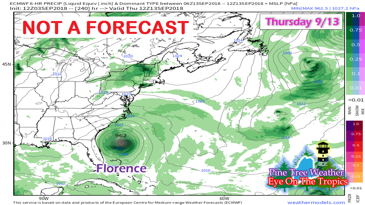 There are several red flags here. First, this forecast is 240 hours out. Second, this only shows one model solution with no comparison to any other model or previous model runs as a basis to figure it out if legitimate or not. Like the epic snow fall model ideas over a 240 hour (European) or 384 hour (GFS) period, they all belong in the trash can. Someone or some people just love to stir the pot and create unnecessary alarm and panic because they have nothing better to do. This image above will be shown, shared and go viral a million or more times, but... 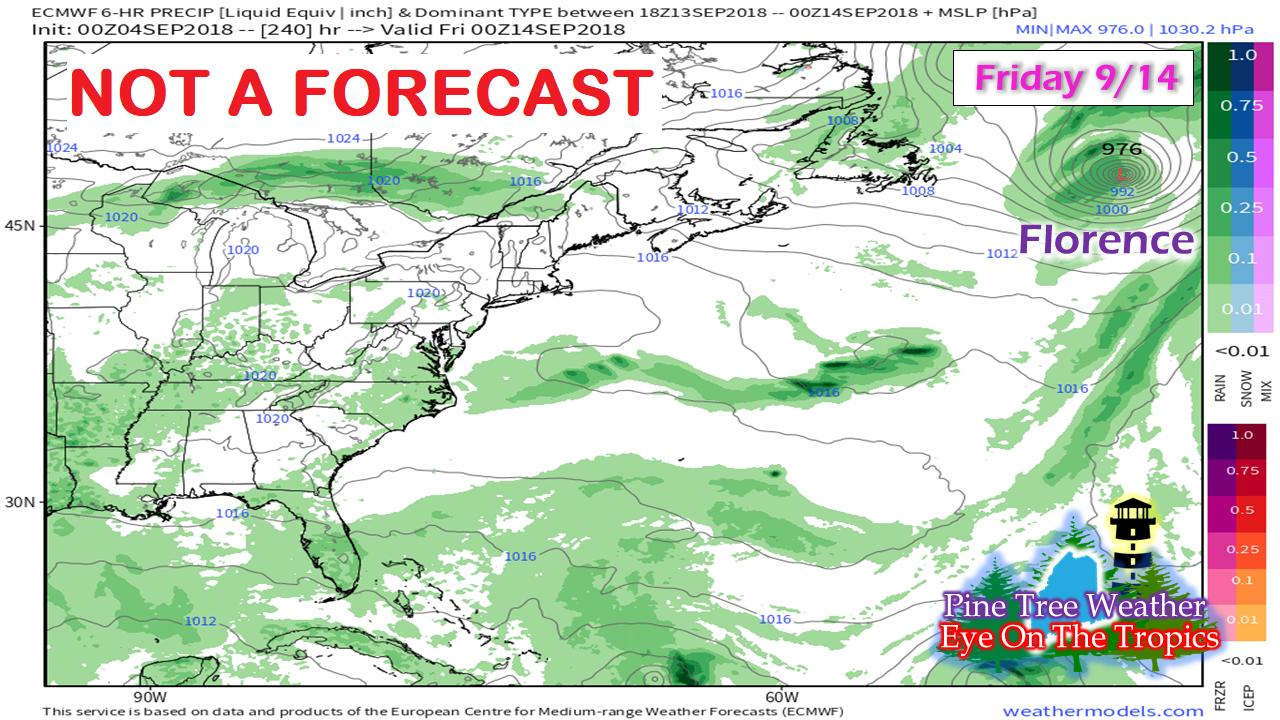 This one here from the same model that ran 12 hours later that chances are real good that it would not be shared by the same people who shared the image of the storm on the doorstep of the southeast. Two totally different ideas in a difference of 12 hours. This happens a lot in potential high impact events. I see it all the time, and I hear about it from worried individuals. So now that I've defined the red dart, I now move onto the blue darts. 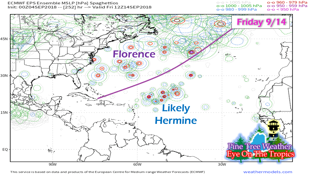 Within each operational model is a group of ensembles. Each are wired in physics to show different ideas based upon how they are programmed. The ensembles are obviously scattered all over the place as this European spaghettios idea indicates. Had all 51 ensemble members been clustered along the southeast coast, then there would be some discussion. That idea only happens within 6 to 24 hours out, and not 240 hours out. As you can see, the ensembles are clearly scattered which immediately puts the operational idea in a file for future reference, which in most cases gets deleted after the storm has passed two weeks later. Now I will turn the spaghettios into spaghetti... 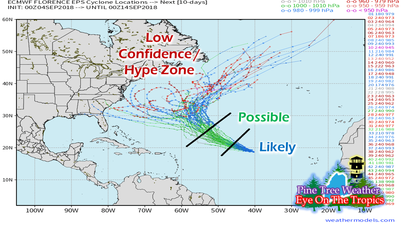 Thinking back to the operational model run that showed doomsday along the southeast coast, the individual members have a vast array of ideas. The point here is there is more to the story than just one single operational red dart model solution... there are 51 ensemble blue dart solutions that go along with it. It's always best to stick to 5-day outlooks posted by the National Hurricane Center or other weather sources that have any sort of respect and integrity to the public. The rest is just purely hype and click bait. Computer generated forecast models have made significant progress in weather forecasting. I've noticed it in the past seven years I have been doing this. Each model has it's strength and weaknesses, hence why it takes human forecasters to create a forecast. Even then, that isn't a guarantee as Mother Nature always gets the final word, and the last laugh. Atmospheric scientists have not broke the code on weather forecasting, which is why it will always be ideas and potential. Forecasting is a truly humbling venture, and the best one could ever hope for is a tie with Mother Nature. There is no winning. Five Day Outlook through the weekend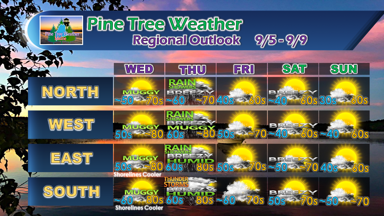 Thursday is the only day to be concerned for any amount of rain or storms through the period. Northern areas and some pockets of protected valleys in the western mountains may see their first frost if not Saturday morning, by Sunday morning. Meteorological fall is showing signs of arrival here in Maine. Dry times to continue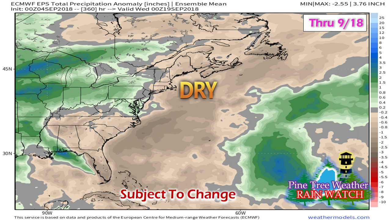 To wrap all the information contained in this post in a neat package, two things are apparent in this European ensemble prediction for rain over the next couple of weeks. For one, rainfall appears to be below normal, which is the obvious one. The second is the ensemble mean keeps all the tropical systems well away from the region.
This pattern is eerily similar to that in the spring, with west to east zonal storm pattern which are moisture starved with little moisture to offer. Given the power keg the tropics are right now, I wouldn't necessarily carve this idea into stone. All it takes is one storm that is tropical in nature to change this on short notice. For those dealing with the ongoing drought, I understand this is not the news you want to see. I keep looking for clues of a more of a wet pattern. It may be another couple of weeks before that happens. For now, conserve your groundwater supplies, and hang in there. Thanks as always for your support! Please consider making a donation to keep Pine Tree Weather going. Check out the donate page on how to contribute. For the latest official forecasts, bulletins and advisories, please check in with the National Weather Service in Gray for western and southern areas, or Caribou for northern and eastern parts of Maine. Always stay weather aware! - Mike |

Mike Haggett
|


