Latest on Tropical Storm Elsa’s track 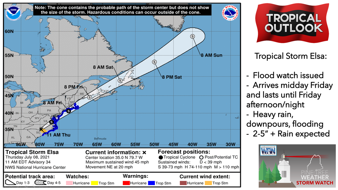 Tropical Storm Elsa is gradually accelerating toward the northeast. Elsa should move near or over southeastern New England and Atlantic Canada during the next 24-48 hours. Impacts include excessive rainfall, flash flooding, tropical-storm-force winds, high surf, and rip currents. Some slight intensification is possible within the next 24-36 hours as it enters the Gulf of Maine as an extra-tropical cyclone before moving out late Friday night. Steady rain continues through Thursday night and into Friday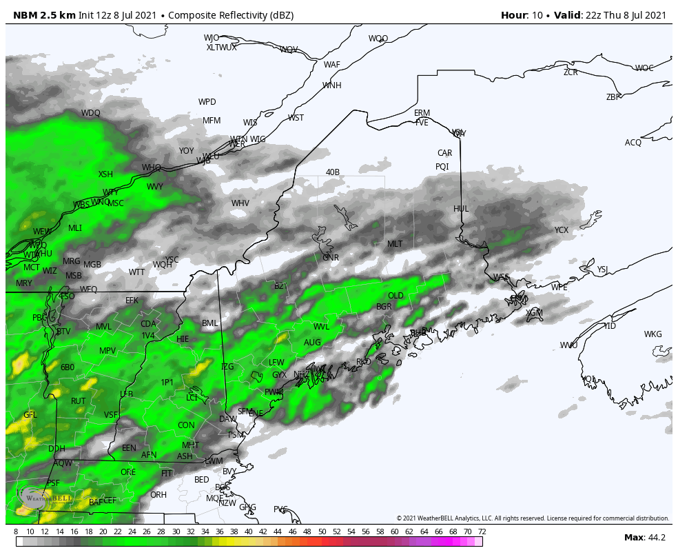 Steady widespread rain showers will continue through Thursday night and into Friday morning from west to east associated with a stalled frontal boundary ahead of Tropical Storm Elsa. Friday is when we should see the center of Tropical Storm Elsa pass just off the coast of Maine. This allows for bands of tropical downpours to move in across the coastal locations and extending into parts of the interior as we move into the early afternoon on Friday. These bands of tropical downpours could produce isolated tropical-storm-force wind gusts and downpours, especially over Downeast Maine due to downdraft winds. High temperatures on Friday will primarily be in the mid-60s to lower 70s statewide. By Friday evening, the rain should begin to taper off for the coastal locations from south to north as Tropical Storm Elsa moves into the Canadian Maritimes. Rain totals from Tropical Storm Elsa through Friday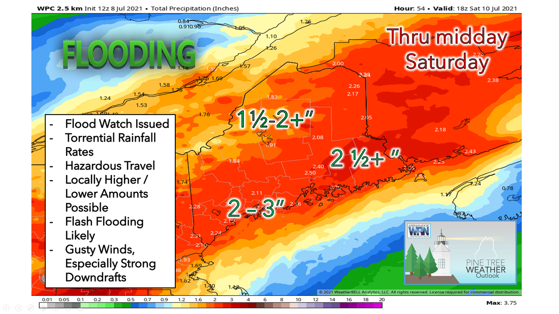 A Flash Flood Watch is in effect for the area from 8 AM Friday until 8 AM Saturday. Torrential rainfall rates of 3-5” + / per hour is possible. Ditches, brooks, streams, and urban streets could turn into small rivers as the rainwater will be looking for places to go. The timing of the heaviest rainfall will be from midday through late afternoon on Friday. Rainfall forecasts are 2-5” along the coastal plain, 1-2” for the eastern interior and foothills, and ½-1¼” for the mountains and areas north. Locally heavier amounts are expected as well. Vertical wind gusts are also expected to bring strong downdraft winds to the region. Horizontal winds don't look to be too extreme for most of our area, gusting 20-30 mph expected at the coast for southern Maine. Gusts of 30-40 mph are possible Downeast and Midcoast. Friday night we should see any remaining showers exit the state with clearing skies expected late. Low temperatures on Friday night should drop into the 50s for Aroostook County and the Highlands with 60s for the coastal areas. Flash Flood Risk 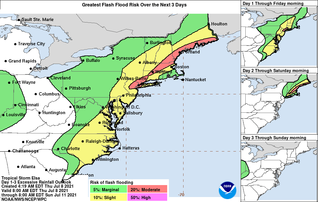 As mentioned before, heavy rainfall and potential flash flooding remain the greatest threat. Generally, 1-3" of rain is expected statewide. Unfortunately, due to our ongoing dry and drought conditions, this will increase the likelihood of water running off the surface and allowing rivers to overflow their banks. Please respect any road barriers and do not try to drive in flooded roadways. Flash flooding can happen very quickly given the amount of rainfall that comes with tropical systems. There is also a gale watch for our coastal waters outlining the possibility for windy conditions as well as increased wave heights around 7-10 feet as the storm passes Friday. Any storm surge that does occur should have a low impact and occur close to noon during high tide. Surf will likely not be too significant, but waters will certainly be more rough than normal so make sure to exercise caution near the ocean. Remember “Turn around and don’t drown”! Weekend outlook 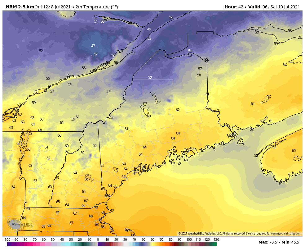 The sun and warmer weather return for the weekend. As the rain comes to an end Friday night, clouds will move out from southwest to northeast improving our weather. Saturday should be a much quieter day with comfortable temperatures and lower dewpoints primarily in the 50s. High temperatures will be in the low to mid-70s statewide. A few pop-up showers can't be ruled out Saturday, however, most areas stay dry. We also will likely see partly to mostly sunny skies for most of Maine on Saturday. High pressure will be positioned near the region on Sunday and Monday yielding to seasonable temperatures and an abundance of sunshine. High temperatures on Sunday and Monday will be around the mid-70s to lower 80s, with the warmest temperatures inland. Beginning of the next workweek 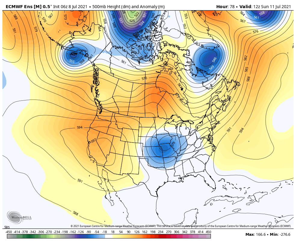 Heading into next week, expect pretty strong ridging developing centered over the mid-Atlantic, with the ridge axis extending up through New England. There could be a few afternoon showers or storms each day, but nothing too concentrated. Temperatures are expected to be slightly warmer than average. Towards Wednesday and Thursday, there are some signs of the ridge weakening with a better chance of showers and storms during the middle of next week. Temperature outlook through mid-JulyThe plots below show the trend of the high and low temperatures for Carrabassett, Bangor, Caribou, and Portland over the next week and a half. Temperatures stay on the cooler side on Friday as Tropical Storm Elsa passes by before becoming warmer over the weekend and into next week. Temperatures will remain right around to slightly above average for this time of year. 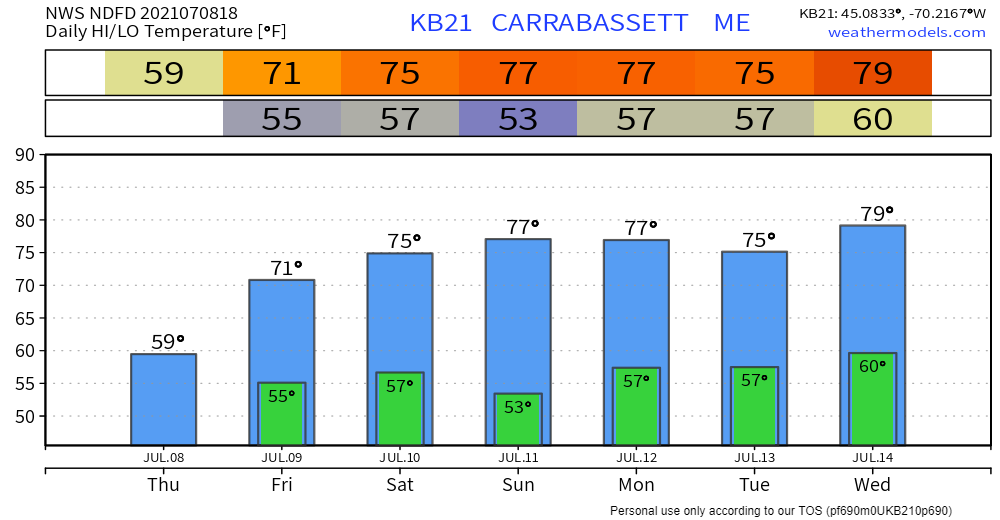 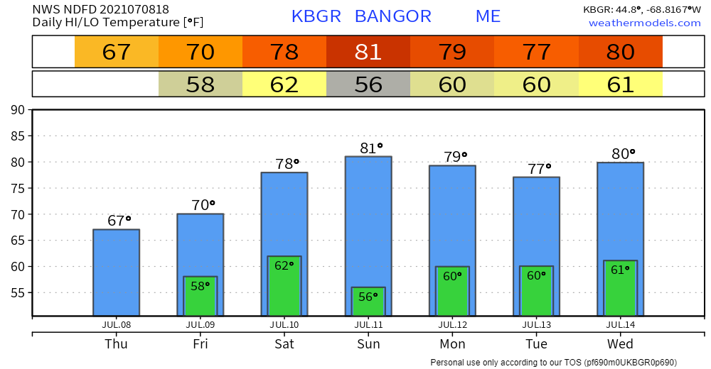 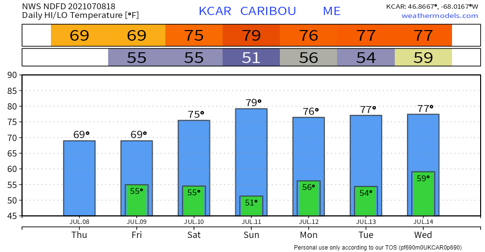 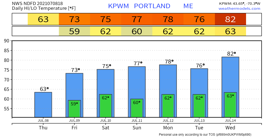 Putting Your Life and Your Rescuer’s Life at Risk When you drive into floodwaters, you’re not only putting your own life at risk, but also the lives of your rescuers. It’s far better to be late and remain safe than to take a risk and possibly lose your life. Turn Around Don’t Drown! weather.gov/safety/flood Be prepared to receive alerts and stay updated!
For more information in between posts, please follow Pine Tree Weather on Facebook and Twitter.
Thank you for supporting this community-based weather information source which operates by reader supported financial contributions. Stay updated, stay on alert, and stay safe! |

Mike Haggett
|