
|
DENSE FOG ADVISORY is posted over southwest and MidCoast regions with reports of fog in DownEast areas. The fog could be stubborn and hang out all day and into Wednesday. Interior areas could see pockets of fog also. Be aware of it as you travel around the area. Pattern outlook through Sunday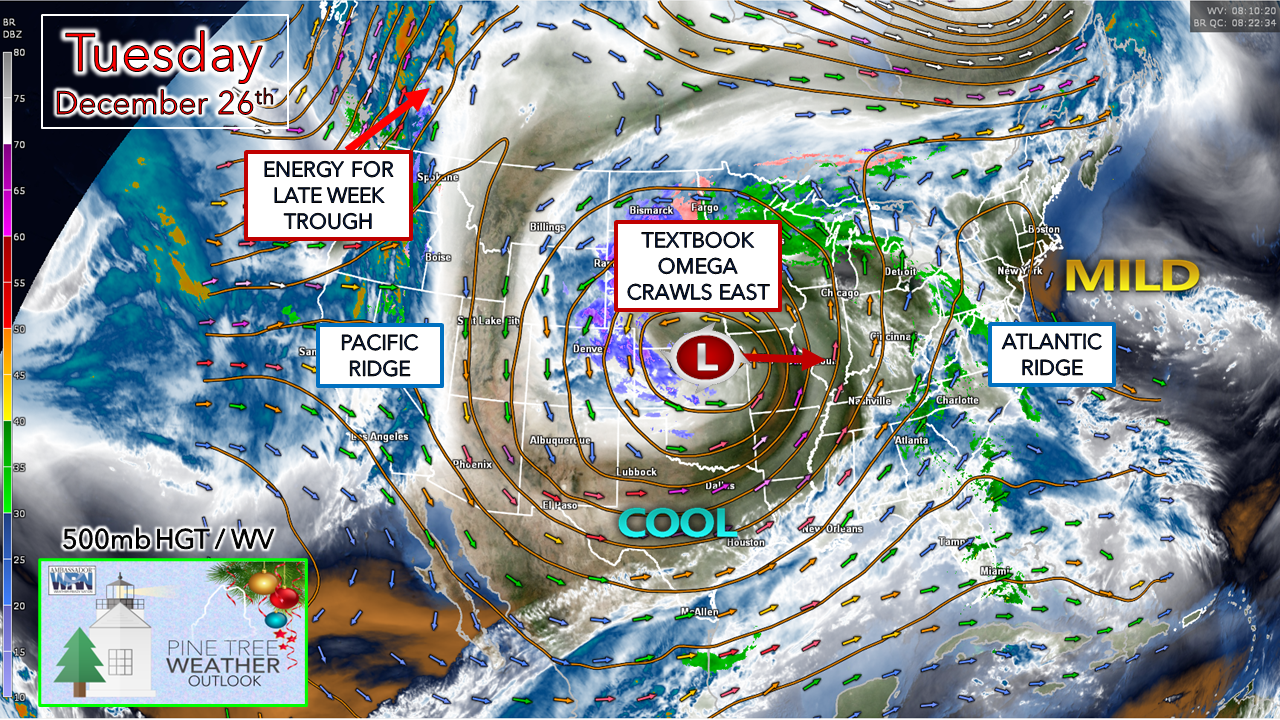 The omega is set up beautifully over the Midwest. An upper-low cut-off inside a strong ridge. Ridging to the west and east keeps it contained. While not a block, it will slowly slide to the east the rest of the week. 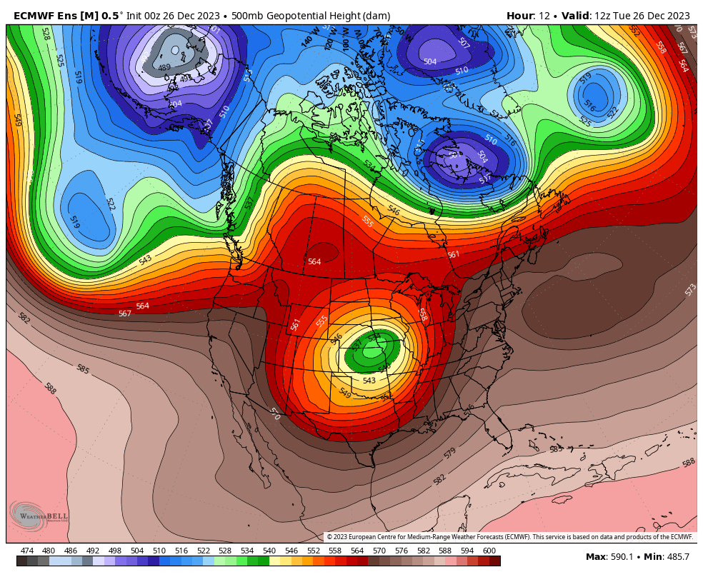 Tuesday 7 AM to Sunday 7 PM - As the omega upper-low slides to the east, it gets absorbed by sharp frontal boundary that dips to the southeast from Hudson Bay. This leads to an unsettled pattern that starts on Wednesday and lasts through Saturday. There is some deep cold brewing over the Arctic. With a strong Pacific ridge that appears to be more of a player heading into January, it appears that Old Man Winter is preparing to arrive in the next couple of weeks. Make sure you have fuel for your heat sources. Stationary front sets up Wednesday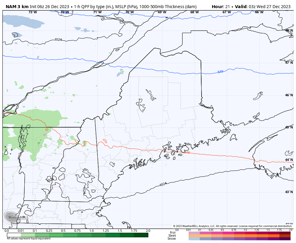 Tuesday 10 PM to Thursday 6 AM - An stalled upper low over Labrador keeps the Atlantic ridge in check. Weak low pressure to the southwest rides along the boundary of the omega and moves northeast and hits a brick wall over Maine. A warm front tries to work in ahead of the low which is expected to bring a mix of warm rain and freezing rain over western and eastern areas during the day Wednesday, with a chance for snow over the north later in the day and into Wednesday night. Which areas get what type of precipitation, how much of it, and for how long depends on the ebb and flow of the stationary boundary and where it sets up. There is some level of uncertainty on that. It's a fair bet that areas along the front could see upwards of ½" of liquid equivalent out of it, with lesser amounts to the north and south of it. With cold air knocking at the door to the north, there is the threat for some amount of icing on a rough line between Jackman - Greenville - Millinocket- Danforth. This is subject to change. Cold air damming will likely be an issue in pockets of the area caught in the boundary. On the cold side of the boundary to the north, the idea of 1-3" of snow is possible, with higher elevations receiving a bit more. On the mild side of boundary to the south, the amount of rain diminishes quickly away from the front. Southern areas may see some light showers, fog, and drizzle. There is not much in the way of wind with this, so no concern with that. Stationary boundaries more times than not turn into nowcasting events. This is likely to happen here. Unsettled and low confidence on outcome through Saturday Thursday 7 AM to Saturday 7 PM - Using the European ensemble mean idea here taking precipitation type out of it given the uncertainty on how this plays out. The piece that will be the player in this is the energy located over the Pacific ridge that drives the trough over Hudson Bay to the southeast into our region late week. Guidance has not come into an agreement on how that will play out. There is the chance for mountain snow with a junky mix possible for Thursday night into Friday for the west, east, and south. The sharper and more steep the trough digs to the southwest could spin up a storm off the MidAtlantic and bring a round of plowable snow for the interior with perhaps as coastal mix heading into Saturday. A slight delay in the arrival of the energy cuts down the threat considerably, with snow showers with light accumulations as the outcome. Given the amount of uncertainty, stay tuned. Temperature outlook through early JanuaryOverall, the region runs on the warmer side of normal over the next ten days. We begin to see a shift toward a cooler trend starting in the first full weekend of the new year. 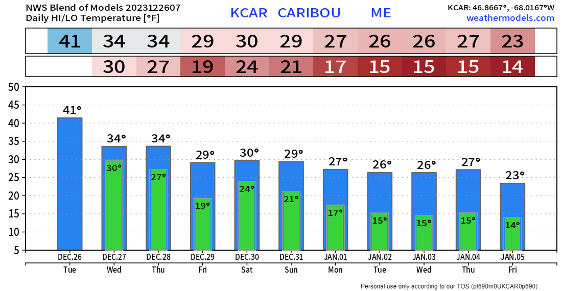 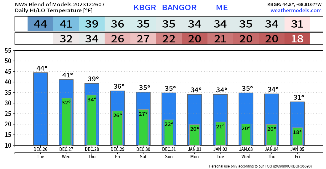 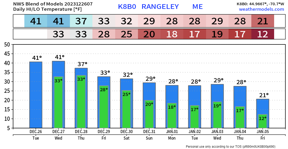 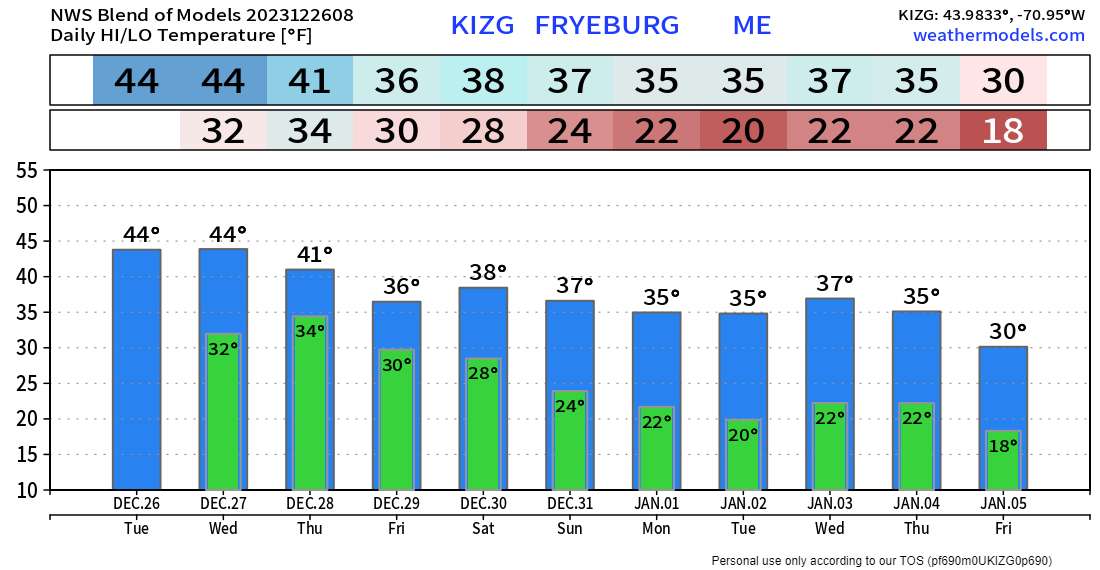 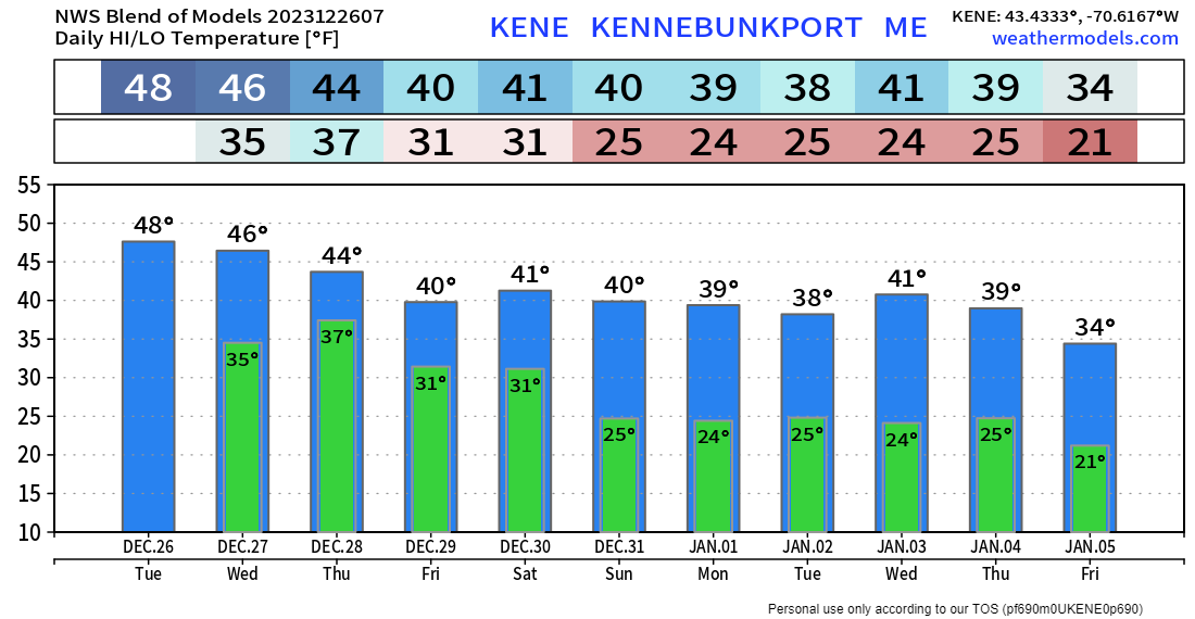 The mission continues because of you Thank you to Allspeed Cyclery & Snow in Portland, Downeast Aerial Photography in Rockland, Dutch Elm Golf Club in Arundel, and Sunrise Property Services in Bridgton, for partnering with Pine Tree Weather. Special thanks to all the individuals who financially contribute. I sincerely appreciate your support. Stay updated, stay on alert, and stay safe! - Mike PRINT MEDIA: Feel free to quote and cite my work here for your stories. Please give me the professional courtesy of knowing that you are referencing my material so I can read your final product and acknowledge it on my media and link it on the Who I Am page here on the website. Feel free to send me a message via the Facebook page or Twitter (X) to get my phone number if necessary. Thank you! NOTE: The forecast information depicted on this platform is for general information purposes only for the public and is not designed or intended for commercial use. For those seeking pinpoint weather information for business operations, you should use a private sector source. For information about where to find commercial forecasters to assist your business, please message me and I will be happy to help you. |

Mike Haggett
|


