Pine Tree Weather
  • DISCUSSIONS
  • Substack
  • WEATHER WALL
  • MARINE
  • CPC OUTLOOK
  • Kennebunk
  • INTERNSHIPS
  • MY BIO
  • PTW IN MEDIA
  • INTERN ALUMNI
  • DISCUSSIONS
  • Substack
  • WEATHER WALL
  • MARINE
  • CPC OUTLOOK
  • Kennebunk
  • INTERNSHIPS
  • MY BIO
  • PTW IN MEDIA
  • INTERN ALUMNI

Tuesday February 27, 2024

2/27/2024

Comments


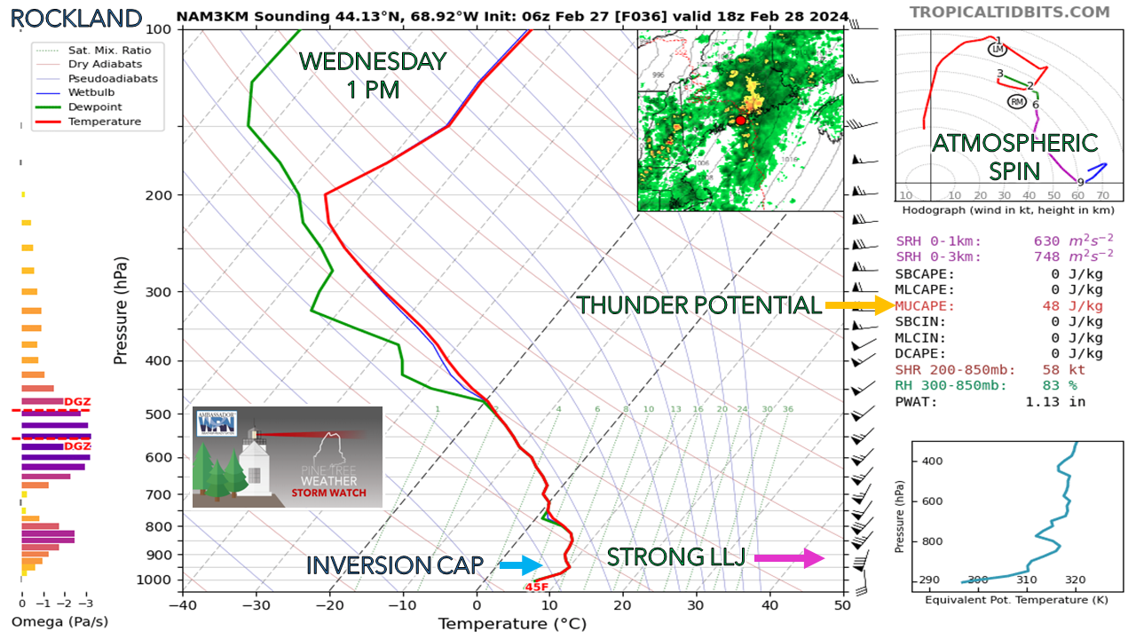
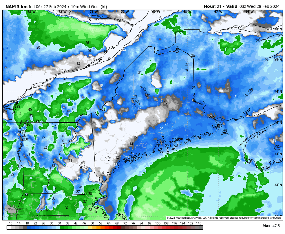
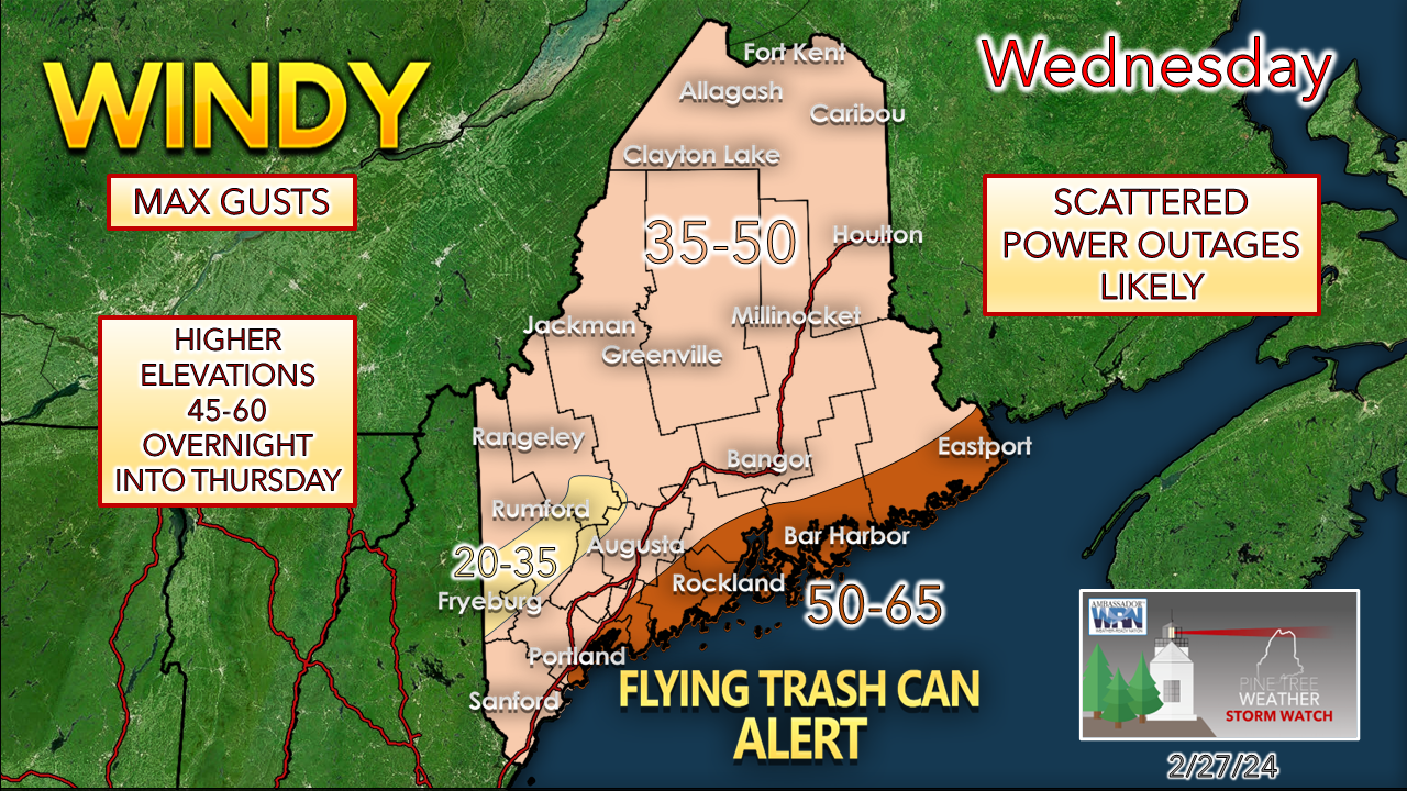
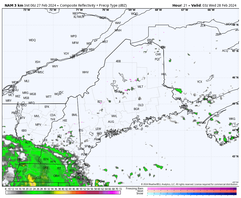
Inside runners: the story of Winter 2023-24

Picture
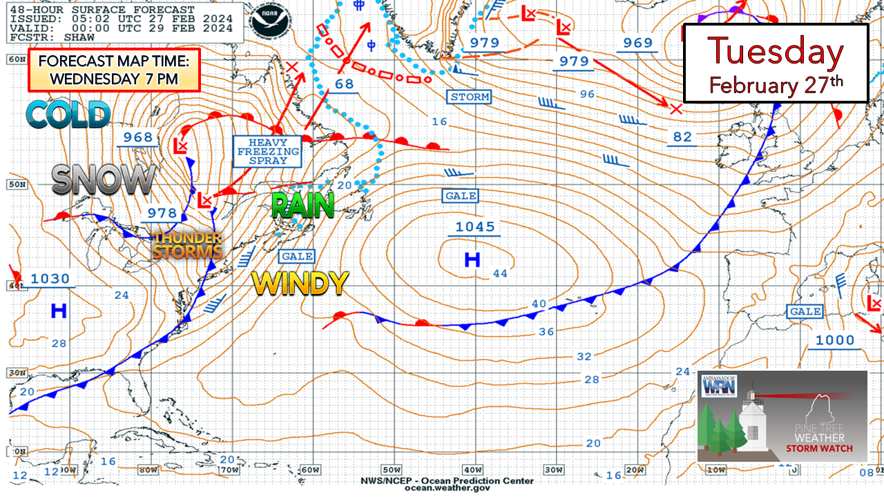
​I spin weather-related jargon at times, which, for the new followers, maybe a bit confusing. I get messages periodically saying “What do you mean about this?” The one that I have used more often this winter has been “inside runner”. Sometimes they are referred to as a “St. Lawrence runner”. To put it in a simple context, it’s the wrong side of a NorEaster, for those wanting snow. All three major storms the region received in December and January were inside runners.  While this one won’t be nearly as potent as those were, it could be problematic in spots. To put it on a spice scale, mild to medium comes to mind as I have pawed over data for the past few days. Wind is likely to be the greatest threat with this one over a fair portion of the region. 

The low-level jet will be there,
​but how strong will the gusts be?

Picture
This is the main question going into this event. Guidance ideas have been mixed on how much the inversion cap plays a role in the outcome.  The cap here is likely caused by the cool ocean with warm tropical moisture riding over aloft. The differing temperatures are like oil to vinegar. That sets up a deflection of the low-level jet, keeping the stronger gusts aloft, but as the corkscrew hodograph in the top right indicates, there is a reasonable amount of spin going on, enough that downdraft winds could occur in areas of heavy rain or in garden variety thunderstorms. 
Picture
Tuesday 10 PM (03z Wednesday) to Thursday 7 AM (12z) - A stiff breeze develops overnight into Wednesday morning and increases as the day goes along.  The shorelines take the brunt of it since there is little in the way to knock the wind down, other than the inversion cap. The high-end risk for strong gusts passes through in the afternoon into the early evening. As the trailing cold front passes through Wednesday night, the wind shifts to the northwest. Given the strong pressure gradient, the threat of the strongest wind shifts to the mountains and north as the system pulls away Thursday morning.
​
While the worst of the wind is expected to be over Thursday morning, the stiff cold breeze is expected to continue through the day and settle down overnight into Friday.
Picture
The bottom line here is that if the inversion cap holds up, wind gusts will bust on the low end. That said, these tropically enhanced systems cannot be trusted. It would be wise to prepare for power loss and travel in the high wind watch region should be minimized with the threat of falling limbs and blowing debris. Counties in the coastal plain not under a high wind watch may end up with a wind advisory.
​
Expect a longer duration wind event, and prepare accordingly.

The precipitation aspect

Picture
Tuesday 10 PM (03z Wednesday) to Thursday 7 AM (12z) - ​Outside of a quick hit of junk for the higher hilltops, this is a rain event for all. Given the tropical infusion, the risk of thunder is there. One of the more intriguing aspects of this setup is the sharp cold filtering behind the frontal boundary. Yes, I am thinking of the chance for thundersnow as the system pulls away. Since this is passing through in the evening, the rumbles could be very loud given the rapid drop in temperature.
 
Precipitation ends from west to east overnight, and by Thursday morning, the wind will be what is left of this storm. 
Picture
​While the flood risk overall is minimal, there is potential for localized issues. Where there are areas of snow, add 1-3” of potential water content trapped in that which may be released with the warm air intrusion. With frozen ground, brooks, streams, and small rivers are a likely destination, along with sensitive basements. The ski hills may be able to absorb what rain is coming, but with dew points above 32° for upwards of 30 hours and fog potential could ripen the pack for melting. 
Picture
A smattering of snow is expected on the backside of the system as the storm departs. Higher elevations may pick up a couple of inches as dynamic cooling is expected to form quicker aloft. For the valleys and areas to the south and east, perhaps a quick coating or a few flakes as a parting gift.
 
Temperatures are expected to crash overnight into Thursday morning. Any standing water that remains will likely turn to black ice on fairly short notice. 

Stay tuned! 

Check out PTW for information 24 hours a day

Picture

​Thank you to Allspeed Cyclery & Snow in Portland, Downeast Aerial Photography in Rockland, Dutch Elm Golf Club in Arundel,
and Sunrise Property Services in Bridgton, for partnering with Pine Tree Weather.

Special thanks to all the individuals and businesses who financially contribute.
​I sincerely appreciate your support. 


Always have MULTIPLE ways to receive weather alerts.
​
Stay updated, stay on alert, and stay safe!

- Mike

PRINT MEDIA: Feel free to quote and cite my work here for your stories. Please give me the professional courtesy of knowing that you are referencing my material so I can read your final product and acknowledge it on my media and link it on the PTW IN MEDIA page here on the website. Feel free to send me a message via the Facebook page or Twitter (X) to get my phone number if necessary. Thank you!

NOTE: The forecast information depicted on this platform is for general information purposes only for the public and is not designed or intended for commercial use. For those seeking pinpoint weather information for business operations, you should use a private sector source. For information about where to find commercial forecasters to assist your business, please message me and I will be happy to help you.

Comments
    Picture

    Mike Haggett
    Kennebunk, ME

    Weather-Ready Nation
    Ambassador

    Certified Weather
    Forecaster
    Penn State '21

    American Meteorological Society

    National Weather Association
    ​
    ​SKYWARN-CWOP

    Matthew 19:26


    DONATE

    Picture
    Picture
    Picture
    Picture
    Picture
    Picture

    Picture

    Picture

    Picture

    Picture

    Picture

    Picture

    Picture

    Picture

    Picture

    Picture

    Picture

    Picture


    Archives

    January 2026
    December 2025
    November 2025
    October 2025
    September 2025
    August 2025
    July 2025
    June 2025
    May 2025
    April 2025
    March 2025
    February 2025
    January 2025
    December 2024
    November 2024
    October 2024
    September 2024
    August 2024
    July 2024
    June 2024
    May 2024
    April 2024
    March 2024
    February 2024
    January 2024
    December 2023
    November 2023
    October 2023
    September 2023
    August 2023
    July 2023
    June 2023
    May 2023
    April 2023
    March 2023
    February 2023
    January 2023
    December 2022
    November 2022
    October 2022
    September 2022
    August 2022
    July 2022
    June 2022
    May 2022
    April 2022
    March 2022
    February 2022
    January 2022
    December 2021
    November 2021
    October 2021
    September 2021
    August 2021
    July 2021
    June 2021
    May 2021
    April 2021
    March 2021
    February 2021
    January 2021
    December 2020
    November 2020
    October 2020
    September 2020
    August 2020
    July 2020
    June 2020
    May 2020
    April 2020
    March 2020
    February 2020
    January 2020
    December 2019
    November 2019
    October 2019
    September 2019
    August 2019
    July 2019
    June 2019
    May 2019
    April 2019
    March 2019
    February 2019
    January 2019
    December 2018
    November 2018
    October 2018
    September 2018
    August 2018
    July 2018
    June 2018
    May 2018
    April 2018
    March 2018
    February 2018
    January 2018
    December 2017
    November 2017
    October 2017

Proudly powered by Weebly