
Original post on Facebook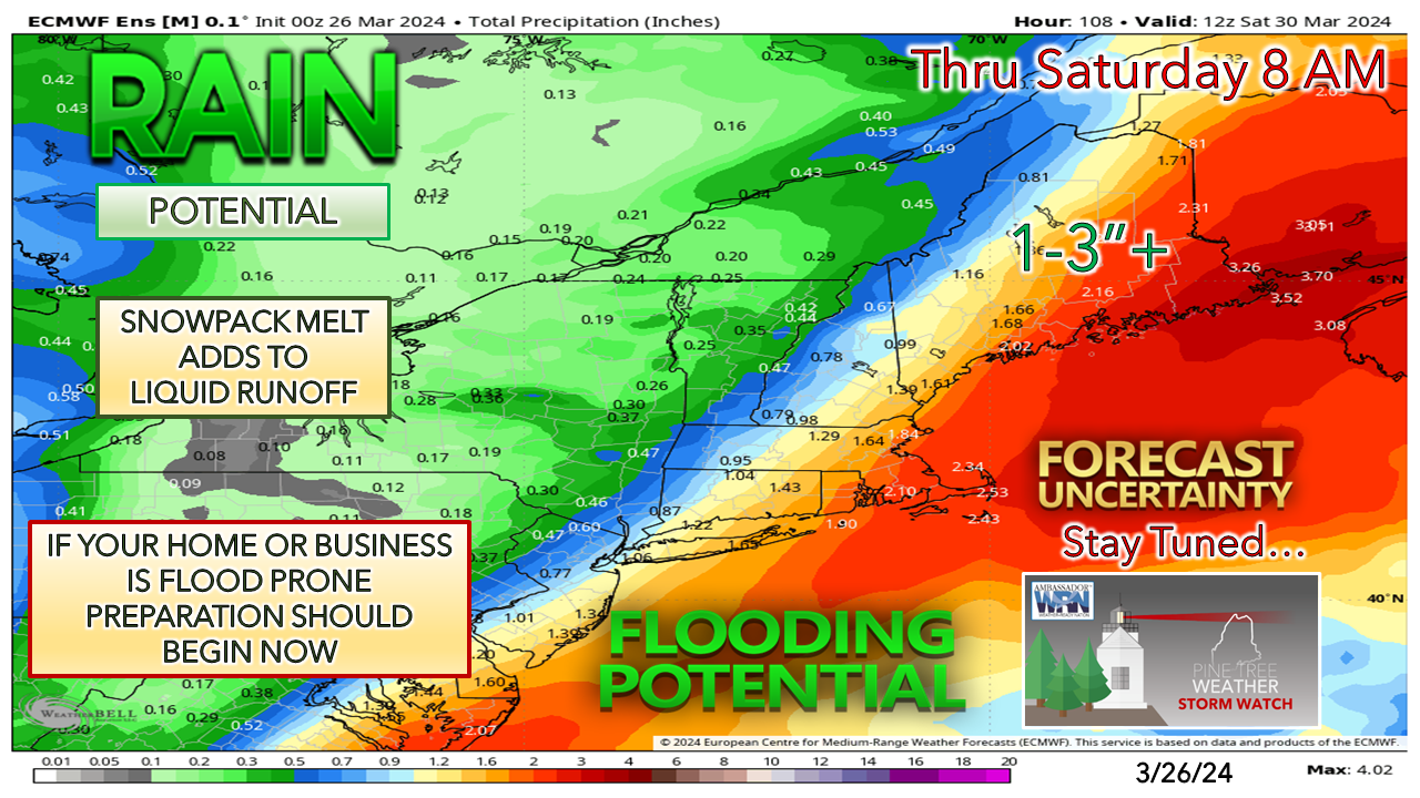 #Maine #MEwx TUESDAY March 26th Update – FLOOD POTENTIAL LATE WEEK
*WATCH OUT FOR AREAS OF FREEZING RAIN, DRIZZLE, AND FOG Tuesday, which may cause some surprise slick spots on the roadways and walkways. Rule of thumb here: if your vehicle thermometer reads ≤ 37°, anticipate road surfaces to be ≤ 32°. The ground has frozen again due to the recent snow dump and cold temperatures. DEW POINT TEMPERATURES begin to climb ABOVE FREEZING Wednesday. This is a CRITICAL feature here. Locked in the snow that was received over the weekend is liquid. Rough estimates I can get from CoCoRaHS observations and radar estimates run in the 2-4” range. (Think 1½- 2” of water per foot of snow, as a rough idea for those looking out the window) The rise in dew points will cause the snowpack to become ripe for melting. The rise in dew points will also cause fog to form, which is the most efficient way to melt snow. Depending on location, this will likely persist for 36-48 hours. The other key piece is the FORECAST IDEAS OF A GENERAL 1-3” OF RAINFALL, with most coming Thursday into Friday. Operational guidance and ensemble ideas like this continue to jog a bit as they struggle to figure out where the frontal boundary that crawls through the region over the next couple of days stalls out. As mentioned in Monday’s post, a more westward track brings more rain into the region, which was anticipated and has tilted that way. Eastern Maine is on track to receive the most out of this as of Tuesday morning. THE COMBINATION of the rise in dew points, the ripening of the snowpack, and forecast rain amounts indicate a potential flood threat. How bad the flooding gets is still to be determined, based on the track (where the front stalls) and the strength of low pressure that forms along it. The snowpack will absorb quite a bit of the rain on the way, but there will likely be some runoff. Rivers that are already running high may rise. Basements prone to flooding may have issues, especially along the coast. WILL THIS BE AS BAD AS THE DECEMBER 18th STORM? No. We don’t have a strong area of low pressure that cuts through the state and dumps 3-5”+ of rain here. RAIN FLIPPING TO SNOW on the system's backside on Friday is a distinct possibility. The best chance for accumulation is over the interior. How much is still to be determined. WIND is not a concern on the system's front side, but as it departs, the speeds increase heading into Saturday. Expect a breeze to continue into Easter Sunday. THIS IS NOT THE FINAL ANSWER. There is wiggle room here. The point is awareness and preparation for those who need time to do so. Fine-tuning to the forecast will come. Stay tuned. - Mike |

Mike Haggett
|


