
Relatively quiet through Thanksgiving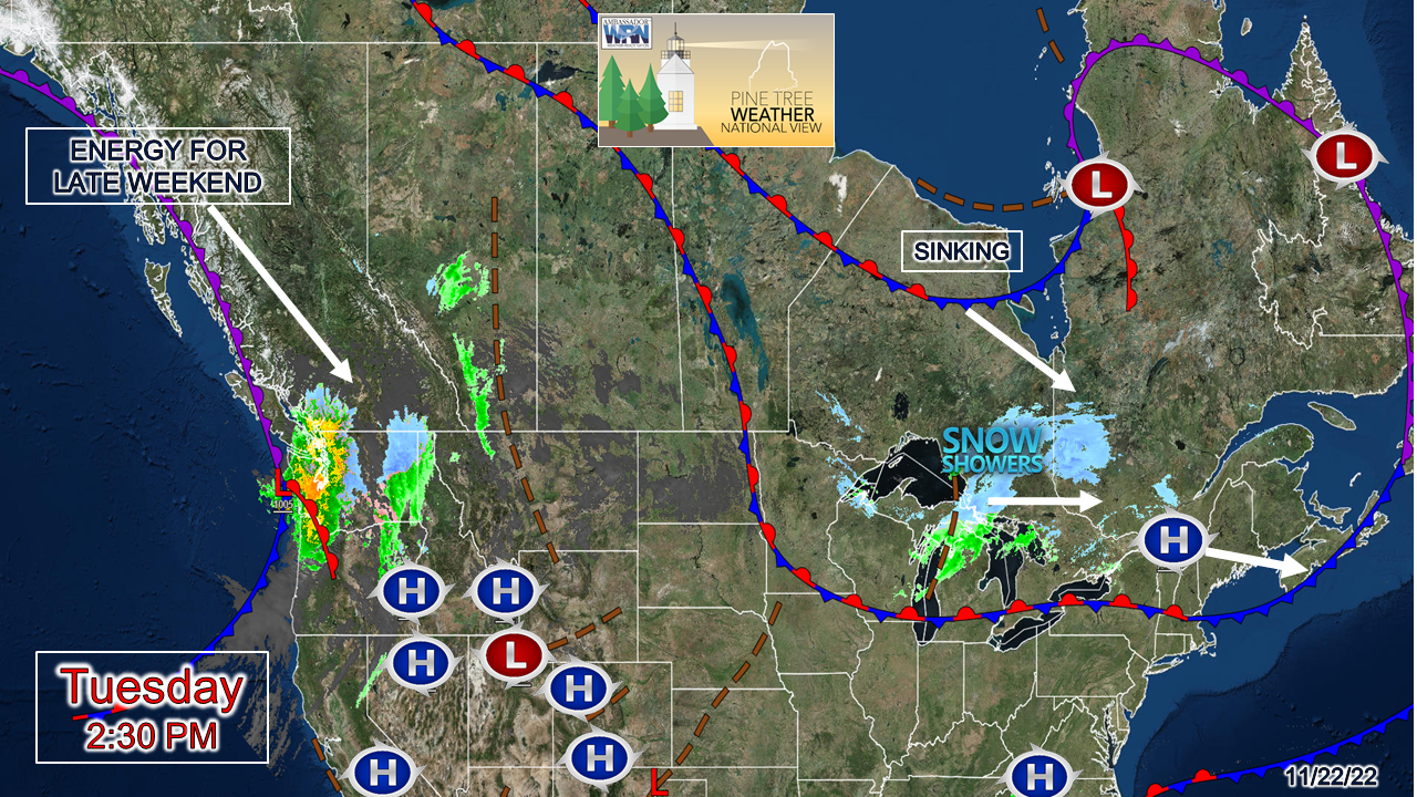 A fast-moving weak cold front near St. James Bay drops into the region Tuesday night into Wednesday morning and brings snow shower activity to the mountains and north. While moisture starved, it could generate enough fluff to bring a coating to couple inches along the Quebec border region and the ski hills for a Currier and Ives effect. No issues with travel are expected outside of a few early morning slick spots on roads less traveled. High pressure works into the region for Thanksgiving. A cold front passes through the region Friday bringing light rain and/or snow showers to the region. High pressure works into the area during a breezy and chilly Saturday, then heads offshore Saturday night. Sunday appears to be a wet ending to the weekend. Looking at the top left of the surface map, you'll see where I added "energy for late weekend"... 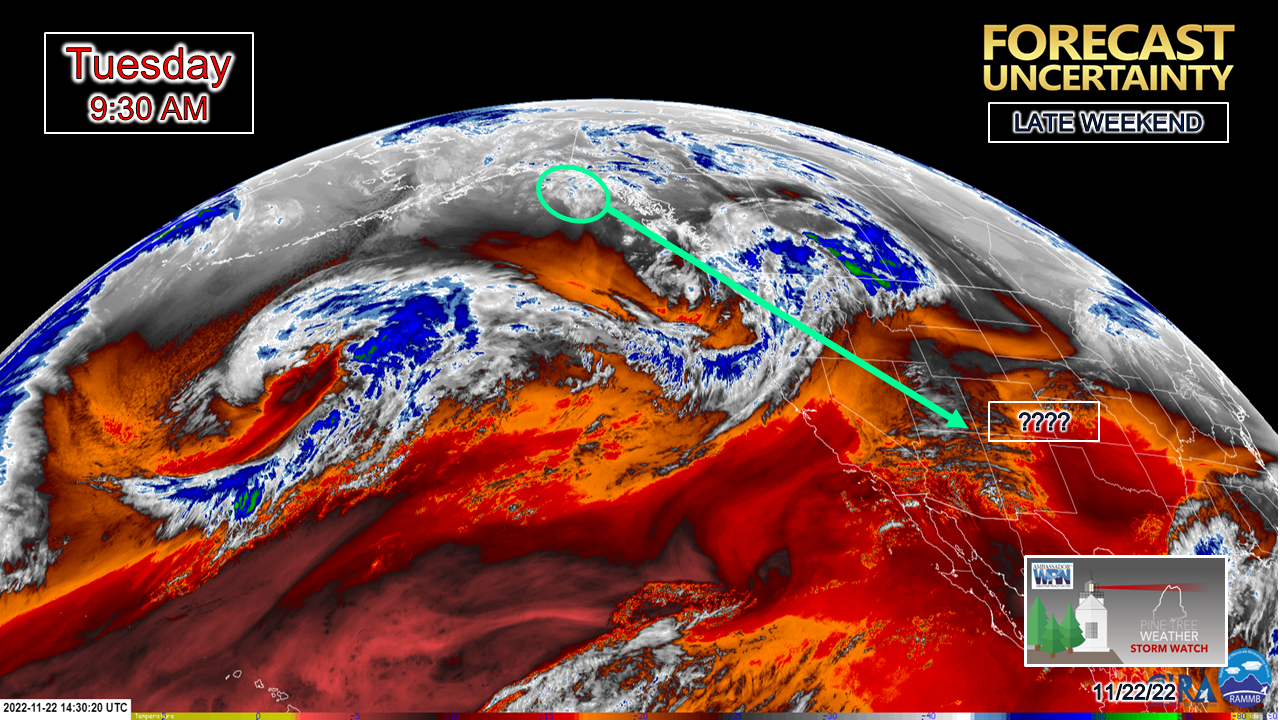 Part of the reason why guidance has been volatile of late is twofold. One, energy associated with what is expected to develop as an upper low over the south is hanging just offshore of Alaska. Radiosondes (weather balloons) have been unable to get a good read on it due to its location. The other wrench in this is where the upper-low is expected to come together is over the Four Corners region, where typically guidance (especially the European model) has a poor record of handling it. This has gone on for years. I know I've mentioned it in the past. It's a bit of a black hole there, and at times is rather annoying when operational ideas spit out impactful storms that end up turning into a page out of a science fiction novel. This is why Friday into Saturday's firehose idea ended up fizzling out, and why there is probable cause to take what is being shown at this point with a grain of salt. Rain and snow showers around for Black Friday Friday 7 AM to Saturday 1 AM - A clipper system drags a cold front through the area for Black Friday. For those headed to the malls early, at this point I expect that it will be a mainly dry affair. Shower chances of the rain (coastal plain) and snow (mountains / north) varieties are possible in the afternoon into Friday night. There is not a whole lot of moisture with this. Ski country may again pick up a couple inches of fluff. The coastal plain may pick up a tenth or two of an inch of rain or less, and some areas may not get more than a sprinkle. As the clipper heads into the Canadian Maritimes, it is expected to turn into a strong ocean storm, thus causing a chilly and breezy start to Saturday. The mountains may pick up another inch of fluff from upslope snow showers Saturday morning early, but that will be about it for precipitation chances statewide. The set up for Sunday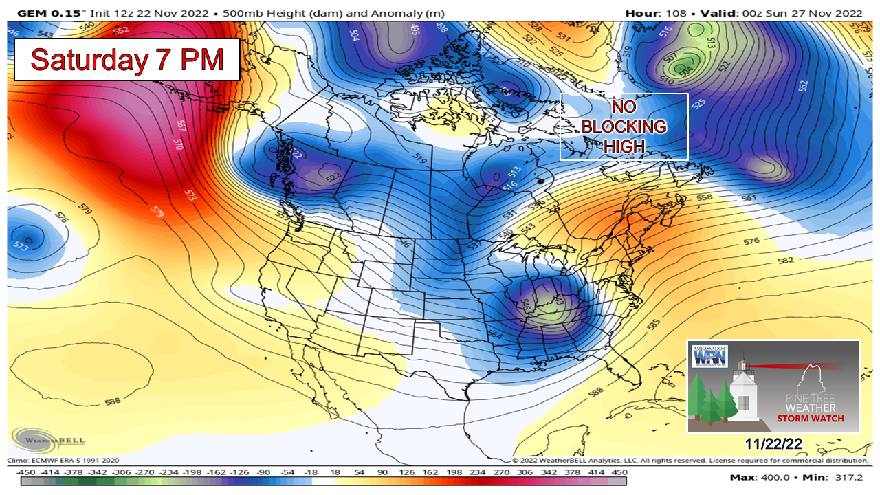 While timing, strength of storm, and rain amounts are still to be determined, where there is common ground between the model ideas is the lack of a blocking high to the north. No blocking high means no cold air to tap into, and the result is the bulk of the precipitation falls in liquid form. Without the blocking high, I don't see how the mountains escape without getting some rain out of this. 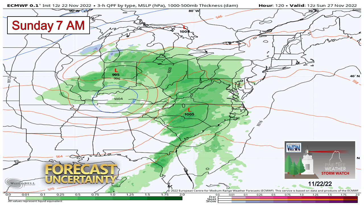 The European model idea is the outlier with a slower progressing system with a dry start to Sunday. Again, this model struggles mightily in these scenarios This cut-off upper low feature really can't be trusted the way models are handling it at the point. 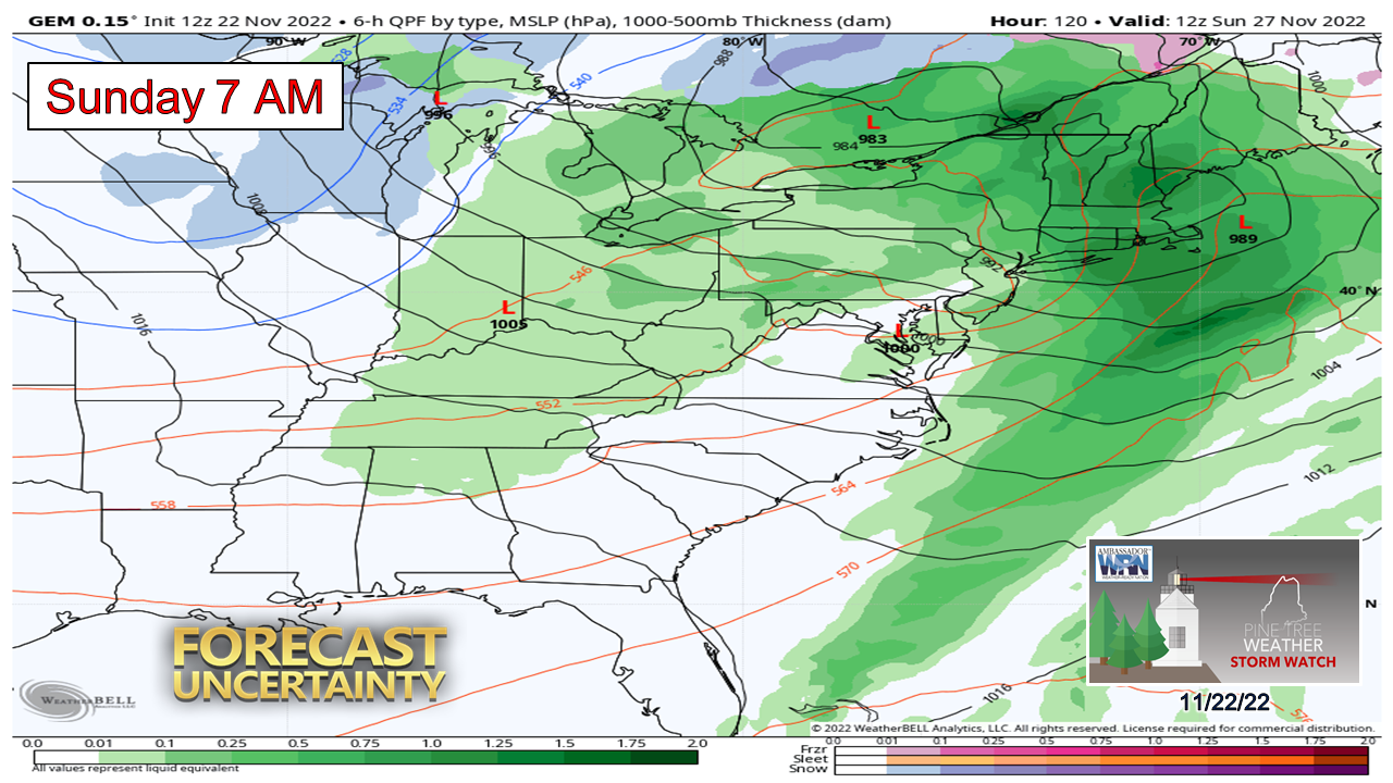 Both the Canadian and GFS models have a fire hose of rain underway statewide by Sunday morning. Again, these ideas can't be trusted given the dynamics involved. I expect forecast ideas to improve on Wednesday and Thanksgiving Day. Stay tuned! Funding for 2023 is currently at 35%... Temperature outlook through SundayThe recent cooler than normal trend since mid-month shifts to above normal temperatures over the weekend and into the few days of November. 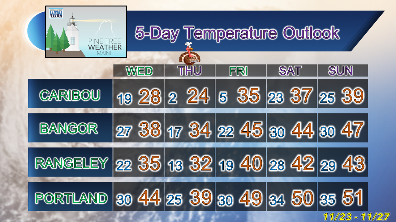 Thank you as always for your support! Stay updated, stay on alert, and stay safe! - Mike NOTE: The forecast information depicted on this platform is for general information purposes only for the public and is not designed or intended for commercial use. For those seeking pinpoint weather information for business operations, you should use a private sector source. For information about where to find commercial forecasters to assist your business, please message me and I will be happy to help you |

Mike Haggett
|


