Pine Tree Weather
  • DISCUSSIONS
  • MAPS
  • BRIEFINGS
  • SATRAD
  • SEVERE
  • MARINE
  • RAIN OUTLOOK
  • SNOW / ICE OUTLOOK
  • CPC OUTLOOK
  • Kennebunk
  • Weather Geekdom
  • Who We Are
  • DONATE
  • My Photography
  • DISCUSSIONS
  • MAPS
  • BRIEFINGS
  • SATRAD
  • SEVERE
  • MARINE
  • RAIN OUTLOOK
  • SNOW / ICE OUTLOOK
  • CPC OUTLOOK
  • Kennebunk
  • Weather Geekdom
  • Who We Are
  • DONATE
  • My Photography

Two chances for snow for southern areas through the week

12/16/2019

Comments


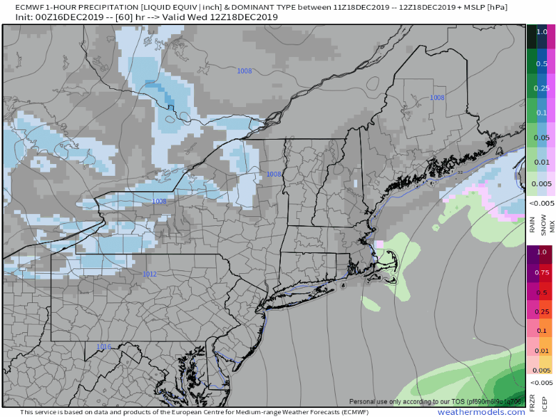
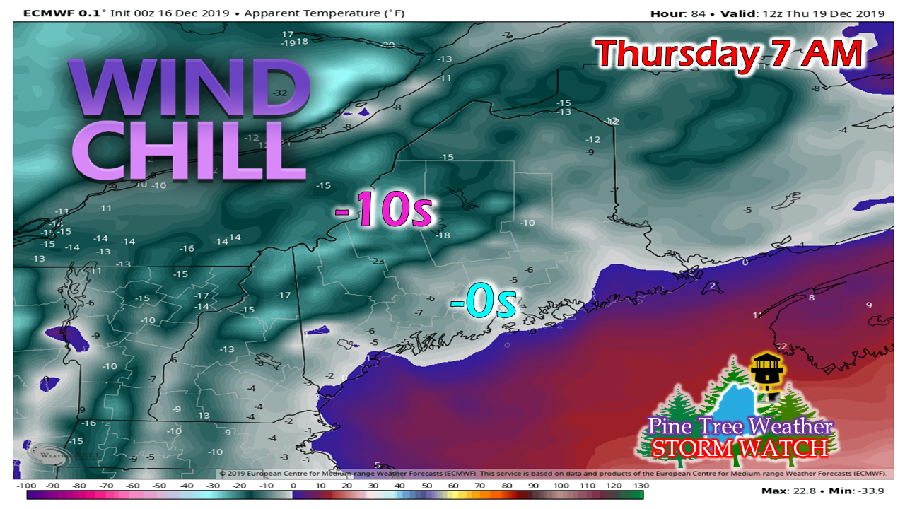
A bitter cold Monday

Picture
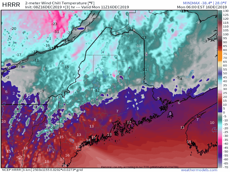
Wind from the departing weekend storm slowly diminishes on Monday. An arctic front that moved through the region Sunday night has allowed temperatures to drop, and brought bitter wind chill along with it. Bundle up as you head out for the day, and expect a chilly one

Tuesday snow coming into focus

Picture
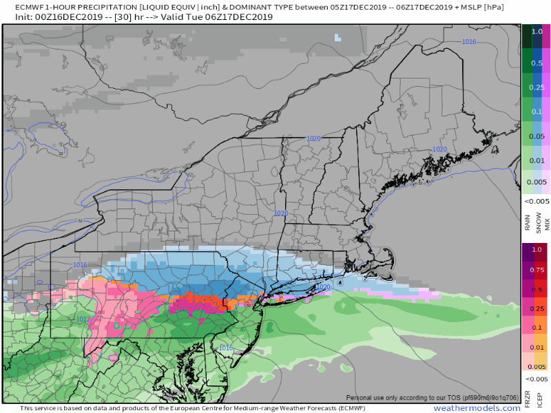
1 AM Tuesday to 7 AM Wednesday
I mentioned in the Sunday afternoon update posted here that this system is coming in flat and it would be a timing game for precipitation, and that remains true. I do not expect any issues for most of the Tuesday morning commute, but snow is likely to develop over southern areas by mid-morning and nudge up into western and eastern areas by the afternoon. As the upper level energy passes through, it will take the snow with it. Snowfall rates appear to be manageable with this one, although I expect some slick areas at the onset due to all the of salt washed off the roads from the rain on Saturday. I suspect the evening commute may be slow going for southern areas. 
Picture
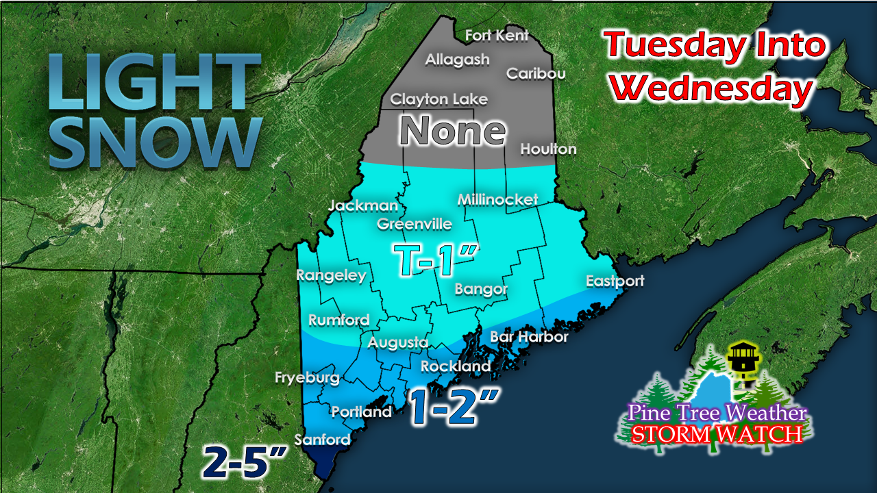
Confidence is medium on this idea. My only question at this point is if this may drop further south a bit more and cut off moisture working in from the southwest. Northern areas appear shut out of this event. 
Picture
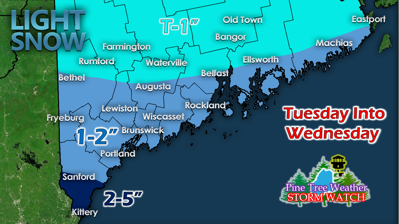
Zooming in on the southern half of the state, southern York county will see the higher end amount, and will regardless no matter what the final answer will be. Folks traveling into southern New England can expect 2-5" of snow, sleet, and freezing rain. If you have a flight out or into Logan, it would be best to check ahead for delays and cancellations on Tuesday into Wednesday morning. 

Inverted trough potential for
​Wednesday night into early Thursday

Picture
As the lead system heads into the Canadian Maritimes, there is potential for an inverted (Norlun) trough set up as weak upper level energy connects with a developing surface low in the Gulf of Maine. Confidence is good that this is likely to occur. For now the focus for snowfall is over western and southern areas, and roughly 1-3" worth starting around the Wednesday evening drive time and continuing through the night, ending around the morning commute Thursday morning. There could be changes as these are tricky to predict, and I will update on this.

On a side note, ski country could benefit with this inverted trough set up, and could get a few inches of fresh powder out of it. It's going to stay cold, so the guns will help rebuild all that was lost over the past week.
Picture
​ On the heels of the trough comes the coldest air mass of the season. It will be a very chilly end to the week.

​Next chance for precipitation comes roughly the second half of the weekend.


► ► For the latest official forecasts, bulletins and advisories, please check in with the National Weather Service in Gray for western and southern areas, or Caribou for northern and eastern parts of Maine.

So close to finish line! 

Picture
► ► $300 shortfall for the year ahead! You can help keep Pine Tree Weather going with a donation of any amount now through VENMO @PineTreeWeather, a monthly donation on Patreon or messaging me on Facebook or Twitter to send a check in the mail. Thank you for your support!

For more information from me, please check the Pine Tree Weather Facebook page as well as my Twitter feed. 

Always stay weather aware!

​- Mike
Comments
    Picture

    Mike Haggett
    Kennebunk, ME

    Penn State
    Weather Forecast Certification '21.
    AMS / NWA
    Weather-Ready Nation 
    ​SKYWARN-CWOP

    Picture

    Alex Hatfield
    Wakefield,MA


    Penn State
    Meteorology and Atmospheric Science ‘21
    PSUBAMS
    Campus Weather Service
    PSU Storm Chase Team
    PSU College of Earth &  Mineral Sciences Ambassador

    Picture

    Kaitlyn Lardeo
    ​Syracuse, NY

    SUNY Oswego
    Atmospheric Science
    Lake Effect Storm Prediction and Research Center
    Northeastern Storm Conference Contributor

    DONATE
    Picture

    Archives

    April 2021
    March 2021
    February 2021
    January 2021
    December 2020
    November 2020
    October 2020
    September 2020
    August 2020
    July 2020
    June 2020
    May 2020
    April 2020
    March 2020
    February 2020
    January 2020
    December 2019
    November 2019
    October 2019
    September 2019
    August 2019
    July 2019
    June 2019
    May 2019
    April 2019
    March 2019
    February 2019
    January 2019
    December 2018
    November 2018
    October 2018
    September 2018
    August 2018
    July 2018
    June 2018
    May 2018
    April 2018
    March 2018
    February 2018
    January 2018
    December 2017
    November 2017
    October 2017

    Categories

    All
    Maine Weather
    Pine Tree Weather

    RSS Feed

Proudly powered by Weebly