Pine Tree Weather
  • DISCUSSIONS
  • DONATE
  • WEATHER WALL
  • MAPS
  • RAIN OUTLOOK
  • SEVERE
  • MARINE
  • CPC OUTLOOK
  • Kennebunk
  • MY BIO
  • PTW IN MEDIA
  • OBSERVING WEATHER
  • INTERNSHIPS
  • INTERN ALUMNI
  • DISCUSSIONS
  • DONATE
  • WEATHER WALL
  • MAPS
  • RAIN OUTLOOK
  • SEVERE
  • MARINE
  • CPC OUTLOOK
  • Kennebunk
  • MY BIO
  • PTW IN MEDIA
  • OBSERVING WEATHER
  • INTERNSHIPS
  • INTERN ALUMNI

Two storms in two days on the way for Maine

2/22/2023

Comments


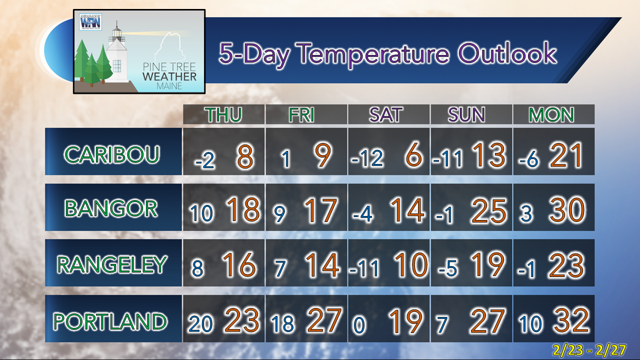
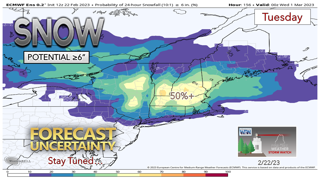
A messy couple of mornings on tap

Picture
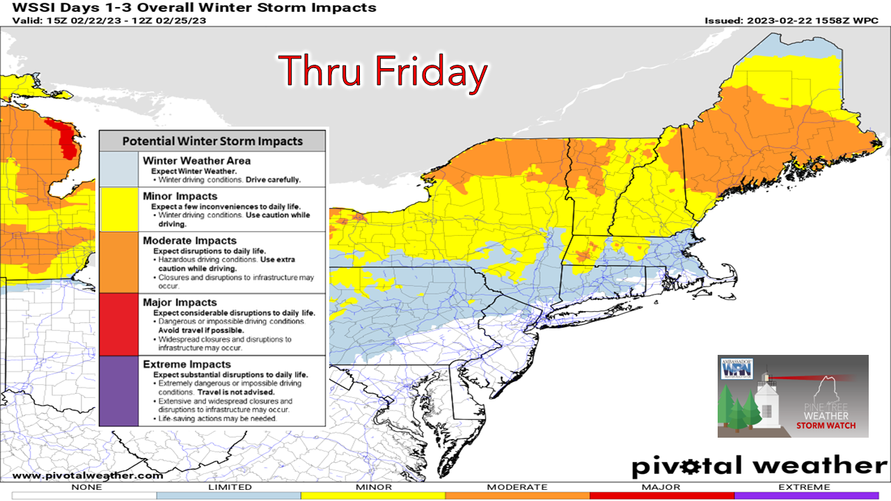
Travel is going to be problematic over the next two mornings. Wind forecasts have increased for the coastal plain Thursday morning, so we'll have some blowing snow to contend with through the day. I mentioned that it will blow everywhere on Friday in Tuesday's post here. That idea continues. 

One thing I want to make clear right away here is there are two separate systems involved with this two day event. In the spirit of minimizing confusion, I am going to treat them separately rather lumping them all into one basket. 

Wednesday night through Thursday 7 PM

Picture
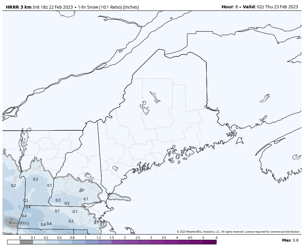
Wednesday 9 PM to Thursday 7 PM - A look at 1-hour snowfall rates with the HRRR model here.
NOTE: This is a 10:1 snow to water ratio idea, and with this likely to be 12-15:1 range, these hourly totals are bit on the light side. 

There is dry air around thanks the to the cold high to the north which may delay snowfall accumulations at the onset, but as the leaf of the warm front progresses northeastward, flakes will being to pile up. Third shifters going to work, overnight travelers and the morning commute could be a very slick affair. 

While a good charge of snow falls in the wee hours of Thursday into the mid-morning hours, snow showers in various intensities are expected to linger through the day, which will bring additional accumulation.
Picture
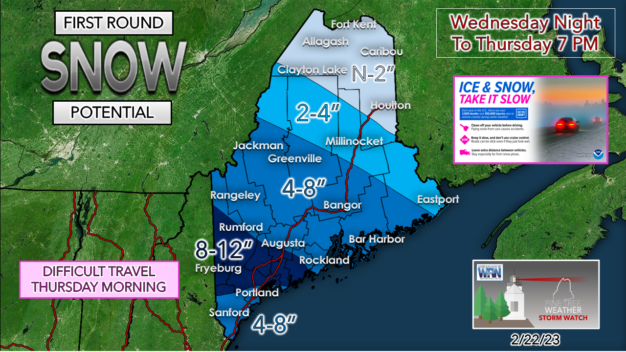
The great debate on whether the warm nose brings sleet in over the south continues. That will dictate the total snowfall amounts. The less sleet, the more snow, the 8-12" could move south into Portland and York County. 

Remember, this is snow totals through 7 PM Thursday! 
Picture
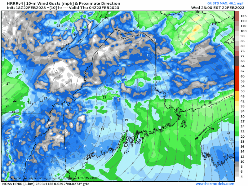
Wednesday 11 PM to Thursday 7 PM - With the warm front approaching, wind speeds will increase. This will cause snow to blow around through the day on Thursday. Wind gusts to around 25 mph won't cause too much of a problem, but it will be enough to blow snow around in the more wide open areas, along with the highways, keeping road crews busy with plowing and salting in spots. 

The wind settles down in the afternoon on Thursday into the early evening. 

Thursday 7 PM into Friday

Picture
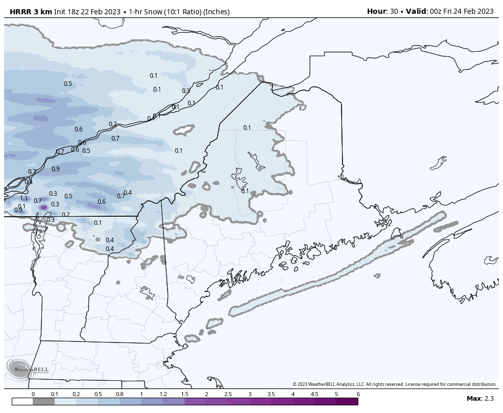
Thursday 7 PM to Friday 1 PM - Round two kicks into gear as low pressure advances eastward. Northern areas that got between little to none on Thursday get in on the game Thursday night into Friday. Snow could be heavy at times Thursday night into the wee hours of Friday. This will be over for most areas by daylight on Friday, outside of eastern areas that may see snow showers linger through midday. 
Picture
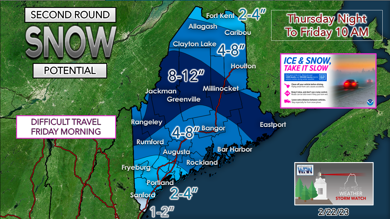
Guidance was a bit juicer today so I am following suit in that thinking. This will be a nothing more than a nuisance over southwestern areas. This should be good for the mountains, Great North Woods and Washington County, and totals may increase over the north. 

Again, another high ratio (15:1) fluff snowfall event appears likely. 

While the snow will have ended for most by daylight Friday morning, I do expect slick conditions through the day as the northwest wind cranks and blows snow around statewide. 
Picture
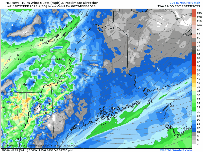
Thursday 7 PM to Friday 1 PM - The wind is expected to be cranking by Friday morning, which will make ongoing clean up an ongoing issue as well as travel in areas as the snow will blow around and drift.  Wind gusts may get into the 40-50 mph range over the mountains and southwestern areas before gradually diminishing Friday afternoon, and settling by Saturday morning. 

While the snow will be fluffy and won't stick, the elevated speeds may cause tree limbs to fall and bring some isolated power outages. 

Picture

Temperature outlook through Monday
Tuesday storm to watch

Picture
We'll have January temperatures in late February and have to like it. Wind chills on Friday are likely to be around 0° or less over a good portion of the state. 

Southwestern areas may pick up 1-2" of fluff on Sunday from an inverted trough set up.

We'll get a brief break on Monday, before the next one hits on Tuesday.
Picture
This idea is going to ebb and flow a bit through the rest of the week. and we'll get a better handle on this over the weekend. Just keep it mind that this is a "thing". Keep your snow blowers tuned up, shovels ready, and perhaps be ready for a potential snow day for the kids, for southwestern areas, at the very least.  

How is your washer fluid level in your car? You may want to check it soon, and fill it up. 

Thank you as always for your support!

You may not like the weather, but I hope you like what I do! Please hit the like button
​on Twitter and Facebook, and share!

Financial donations to fund what I do are always appreciated!

Stay updated, stay on alert, and stay safe!

- Mike

​NOTE: The forecast information depicted on this platform is for general information purposes only for the public and is not designed or intended for commercial use. For those seeking pinpoint weather information for business operations, you should use a private sector source. For information about where to find commercial forecasters to assist your business, please message me and I will be happy to help you

Comments
    Picture

    Mike Haggett
    Kennebunk, ME

    Weather-Ready Nation
    Ambassador

    Certified Weather
    Forecaster
    Penn State '21

    American Meteorological Society

    National Weather Association
    ​
    ​SKYWARN-CWOP

    Matthew 19:26


    DONATE

    Picture
    Picture
    Picture
    Picture
    Picture

    Picture

    Picture

    Picture

    Picture

    Picture

    Picture

    Picture

    Picture

    Picture

    Picture

    Picture

    Picture


    Archives

    May 2025
    April 2025
    March 2025
    February 2025
    January 2025
    December 2024
    November 2024
    October 2024
    September 2024
    August 2024
    July 2024
    June 2024
    May 2024
    April 2024
    March 2024
    February 2024
    January 2024
    December 2023
    November 2023
    October 2023
    September 2023
    August 2023
    July 2023
    June 2023
    May 2023
    April 2023
    March 2023
    February 2023
    January 2023
    December 2022
    November 2022
    October 2022
    September 2022
    August 2022
    July 2022
    June 2022
    May 2022
    April 2022
    March 2022
    February 2022
    January 2022
    December 2021
    November 2021
    October 2021
    September 2021
    August 2021
    July 2021
    June 2021
    May 2021
    April 2021
    March 2021
    February 2021
    January 2021
    December 2020
    November 2020
    October 2020
    September 2020
    August 2020
    July 2020
    June 2020
    May 2020
    April 2020
    March 2020
    February 2020
    January 2020
    December 2019
    November 2019
    October 2019
    September 2019
    August 2019
    July 2019
    June 2019
    May 2019
    April 2019
    March 2019
    February 2019
    January 2019
    December 2018
    November 2018
    October 2018
    September 2018
    August 2018
    July 2018
    June 2018
    May 2018
    April 2018
    March 2018
    February 2018
    January 2018
    December 2017
    November 2017
    October 2017

Proudly powered by Weebly