Pine Tree Weather
  • DISCUSSIONS
  • DONATE
  • MAPS
  • NWS BRIEFINGS
  • SATRAD
  • MARINE
  • SNOW / ICE OUTLOOK
  • RAIN OUTLOOK
  • CPC OUTLOOK
  • Kennebunk
  • OBSERVING WEATHER
  • Who We Are
  • My Photography
  • DISCUSSIONS
  • DONATE
  • MAPS
  • NWS BRIEFINGS
  • SATRAD
  • MARINE
  • SNOW / ICE OUTLOOK
  • RAIN OUTLOOK
  • CPC OUTLOOK
  • Kennebunk
  • OBSERVING WEATHER
  • Who We Are
  • My Photography

Unsettled midweek with mixed precipitation chances, winter to return Thursday

1/1/2023

Comments

 
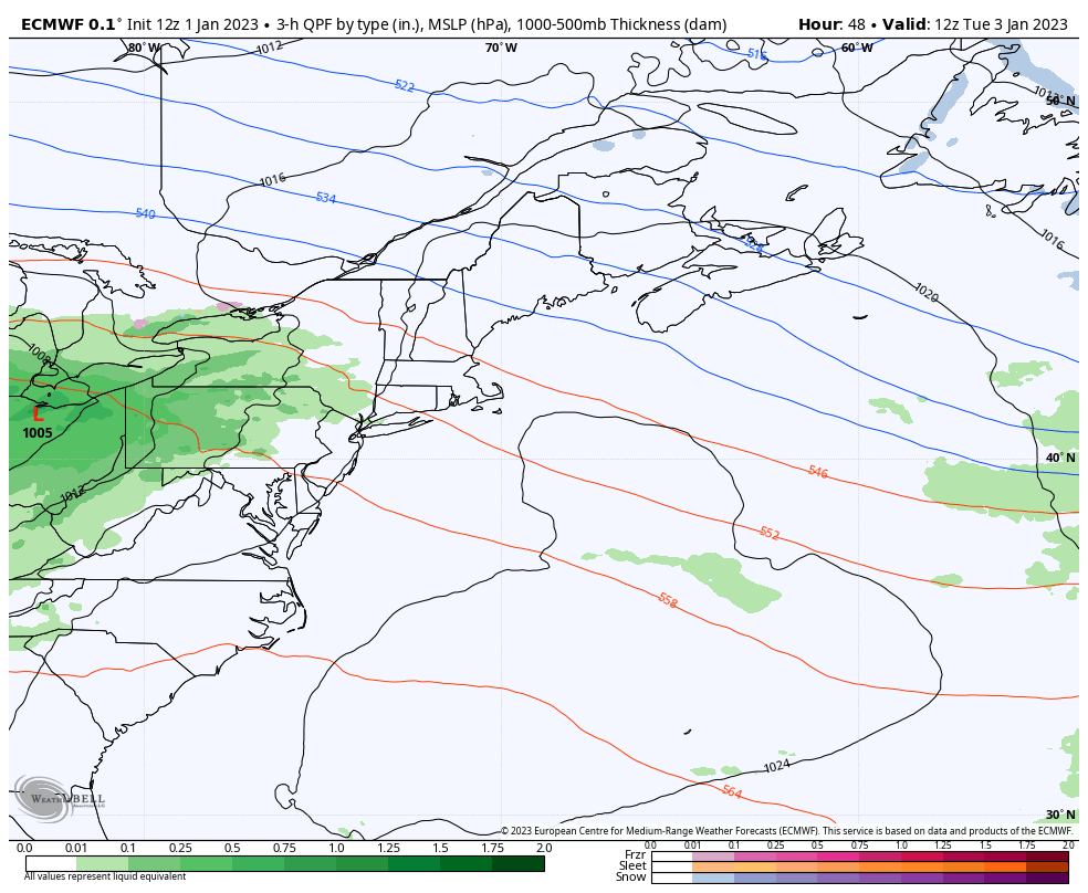
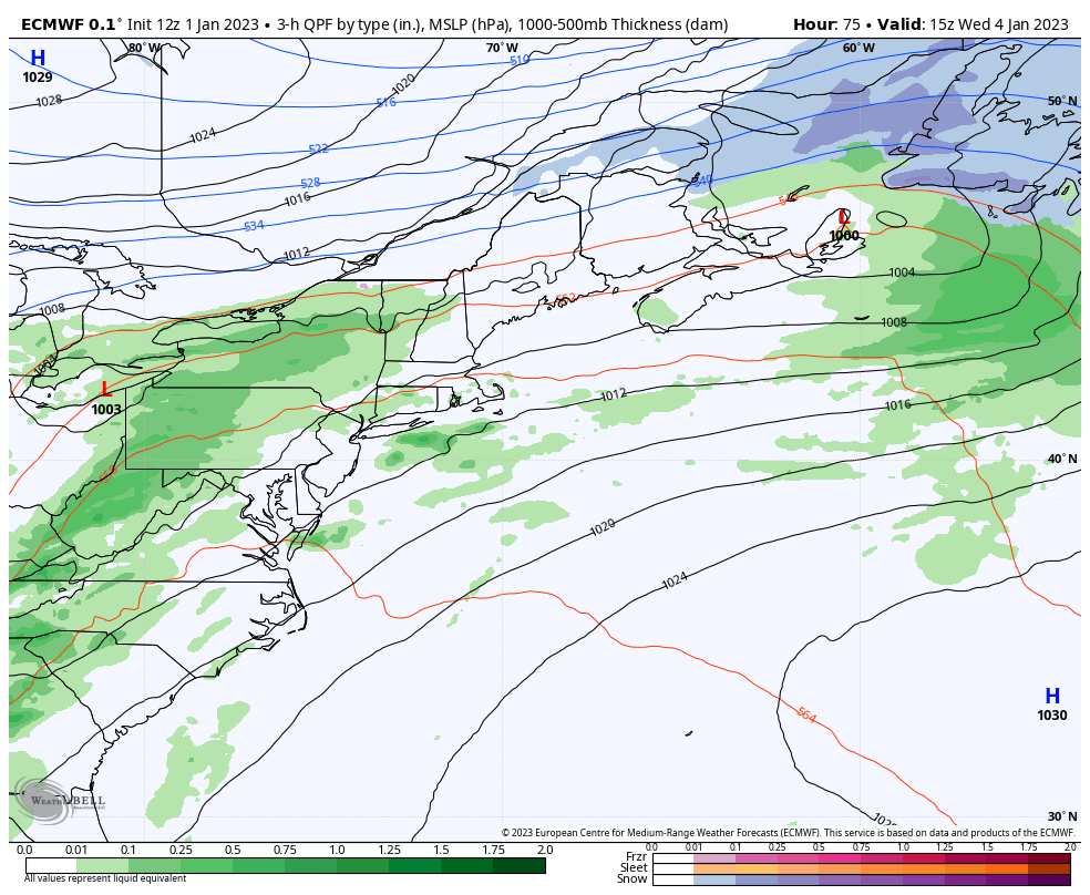
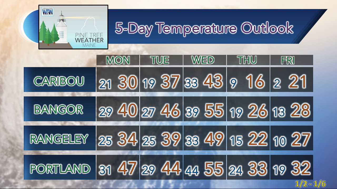
Happy New Year! A personal note to start off to say I have very busy week ahead to start the year with a couple of medical appointments, an American Meteorological Society committee meeting, and a couple of personal and family related matters to deal with that will interrupt my usual posting routine. I will do what I can, when I can, as best as I can as the week unfolds. Thankfully, there is nothing of widespread concern, but there are a couple of things to be aware of. 

Temperatures feel more like April to start the year

Picture
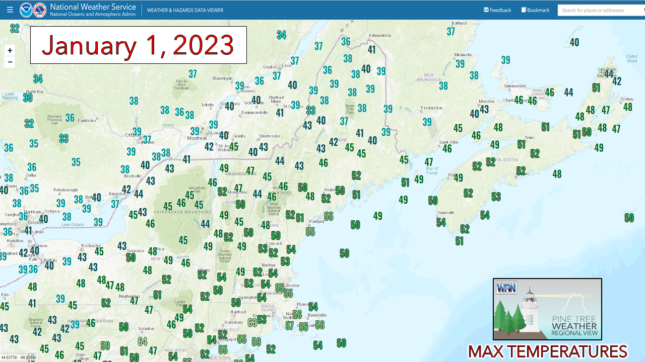
Several records have been broken or tied between daily highs and warm overnight lows across northern areas along with Augusta in the south. The normal high and low for Caribou is 23° and 6°, and for Portland 34° and 18°. Even with the clouds and periodic shower activity over the north temperatures topped around 20° above normal there. With the sun out over the coastal plain, that also helped for the daily highs to be 20°+ there. 

Looking back at history for Portland and Caribou, we've had a few warm first of January days...
Picture
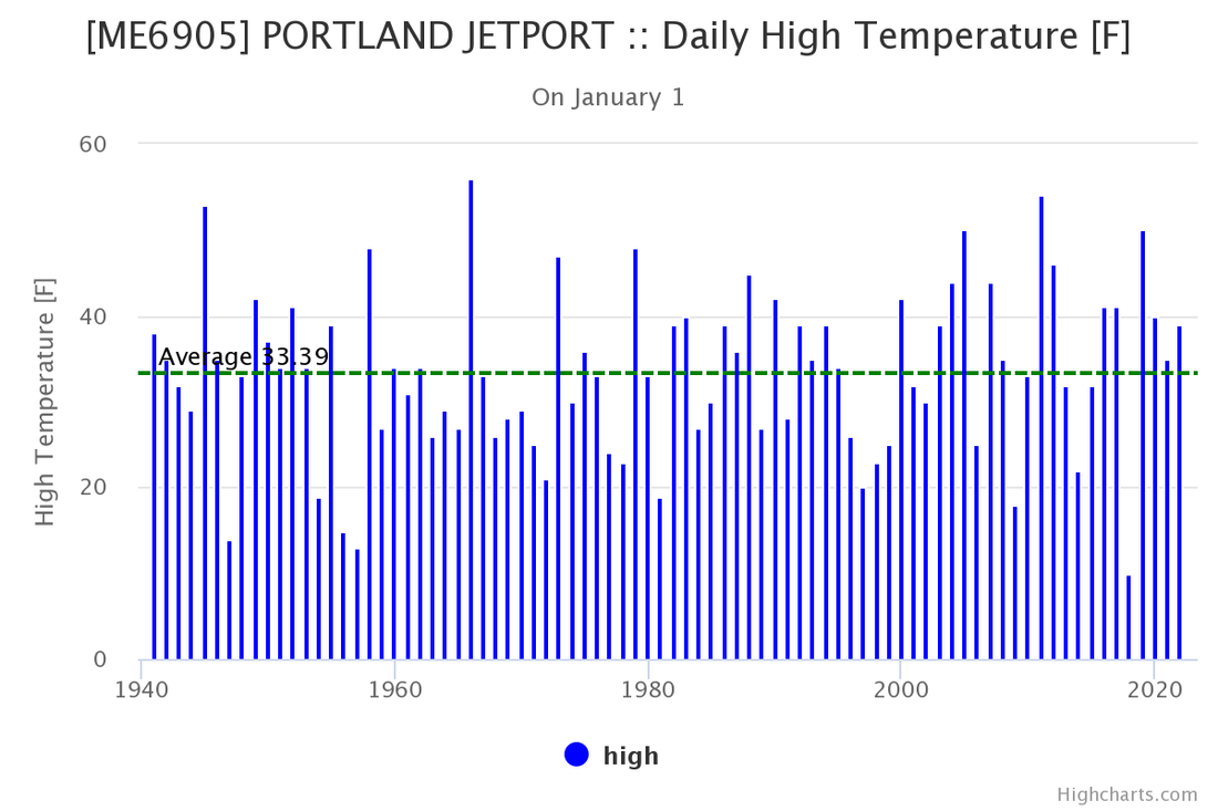
The all-time high for January 1st in Portland was 56° set back in 1966. At last check, the Jetport reached 55° unofficially, so it appears that record will stay intact. 
Picture
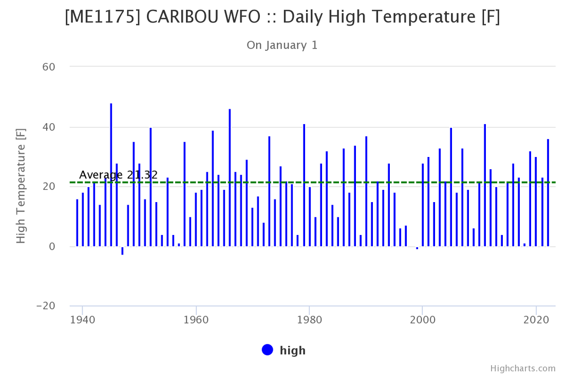
Caribou's all-time record high of 48° for the day was set back in 1945, and that record won't be challenged as the unofficial daily high there is 39°.  

We're not challenging and setting records as of yet as this anomalously warm air sticks around through Wednesday.  

Upper-level outlook for the week

Picture
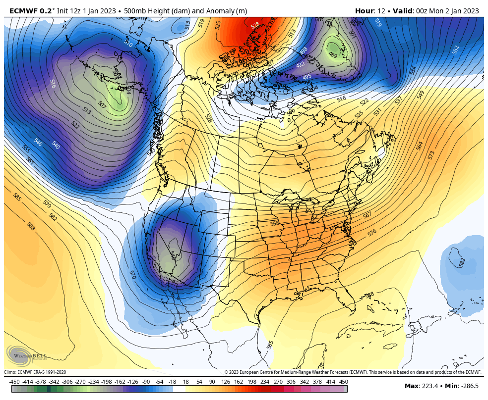
Sunday 7 PM to Friday 7 PM - The two main hotspots on the continent this week are the deep south and the west coast. The south deals severe weather on Monday and Tuesday thanks to a sharp upper-level trough digging there. The west coast gets hammered midweek thanks to a strong upper-level low that taps into an atmospheric river stretching from Japan all the way to California. As forecasters we apprehensively quip at times that droughts don't end well, this is Exhibit A going on there. The Oriental Express is expected to bring major snow to the Sierras and an unrelenting fire hose of rain that will go on for days. You'll be seeing some epic stories on this. Pray for them and the folks down south also as they will get lit up, too. 

For us in the east a split flow sets up keeping the area warm and void of any significant systems. The cut-off upper-level low feature is where most of our activity comes from mid to late week. The ridge collapses enough to allow temperatures to fall back to average from Thursday onward.

A chance for showers and mixed precipitation
Tuesday to Friday

Picture
Tuesday 7 AM to Wednesday 10 AM - The ridge begins to collapse and disturbances from the south work along it. For the first wave of activity, interior areas should be on alert for sleet and freezing rain potential Tuesday afternoon into the evening, along with some light snow potential for the far north. Areas south of the foothills appear to stay warm enough for rain showers as the upper ridge holds temperatures above freezing there. 

If you live and/or travel in the foothills, mountains, and north, know that the salt has washed off the roads and watch the thermometer closely for potential slick spots.  There is roughly ¼-½" of liquid involved here that will land on terra firma in some form, whether frozen, about to freeze, or not depending on how the thermals set up.
Picture
Wednesday 10 AM to Friday 1 AM - The forecast for this time period has been a challenge due to timing of the second system and how high pressure to the north impacts the upper-low to the south, and Maine is in the crosshairs of it.  It's too early to figure out how much of what type of precipitation and where at this point. The amount of liquid involved is similar to the previous wave at ¼-½". The area of low pressure is pretty flat, and these types of systems where the atmosphere is constipated thermodynamically are a tough call. Expect a junk storm (snow, sleet, freezing rain) at this point starting Wednesday night into Thursday that may bring some travel impacts and could get the salt trucks out. 

Expect a temperature whiplash back to reality to hit Thursday, as you will see below. 

​Keep yourselves updated! 

Temperature outlook through Friday

Picture

Thank you as always for your support!

You may not like the weather, but I hope you like what I do! Please hit the like button
​on Twitter and Facebook, and share!


Stay updated, stay on alert, and stay safe!

- Mike

​NOTE: The forecast information depicted on this platform is for general information purposes only for the public and is not designed or intended for commercial use. For those seeking pinpoint weather information for business operations, you should use a private sector source. For information about where to find commercial forecasters to assist your business, please message me and I will be happy to help you.

Comments
    Picture

    Mike Haggett
    Kennebunk, ME

    Certified Weather
    Forecaster
    Penn State '21

    American Meteorological Society

    National Weather Association

    Weather-Ready Nation 
    Ambassador
    ​
    ​SKYWARN-CWOP

    Matthew 19:26


    Support
    Pine Tree Weather

    DONATE

    Picture

    Picture

    Picture

    Picture

    Picture

    Picture

    Picture

    Picture

    Picture

    Picture

    Archives

    January 2023
    December 2022
    November 2022
    October 2022
    September 2022
    August 2022
    July 2022
    June 2022
    May 2022
    April 2022
    March 2022
    February 2022
    January 2022
    December 2021
    November 2021
    October 2021
    September 2021
    August 2021
    July 2021
    June 2021
    May 2021
    April 2021
    March 2021
    February 2021
    January 2021
    December 2020
    November 2020
    October 2020
    September 2020
    August 2020
    July 2020
    June 2020
    May 2020
    April 2020
    March 2020
    February 2020
    January 2020
    December 2019
    November 2019
    October 2019
    September 2019
    August 2019
    July 2019
    June 2019
    May 2019
    April 2019
    March 2019
    February 2019
    January 2019
    December 2018
    November 2018
    October 2018
    September 2018
    August 2018
    July 2018
    June 2018
    May 2018
    April 2018
    March 2018
    February 2018
    January 2018
    December 2017
    November 2017
    October 2017

    RSS Feed

Proudly powered by Weebly