
|
Last Friday I was walking our dog Buddy early in the morning and I ended up getting stung by a ground wasp on my right leg. I ended up at an urgent care facility Sunday afternoon to seek treatment under advisement of my registered nurse wife, who noticed the swelling had increased after I returned home after a morning round of golf. So, I sit here and type at 5 AM with my leg up on ice, under antibiotics, antihistamine, and ibuprofen, and have been told to take it easy. Needless to say, I am day-to-day for updates at this point. So much fun. National view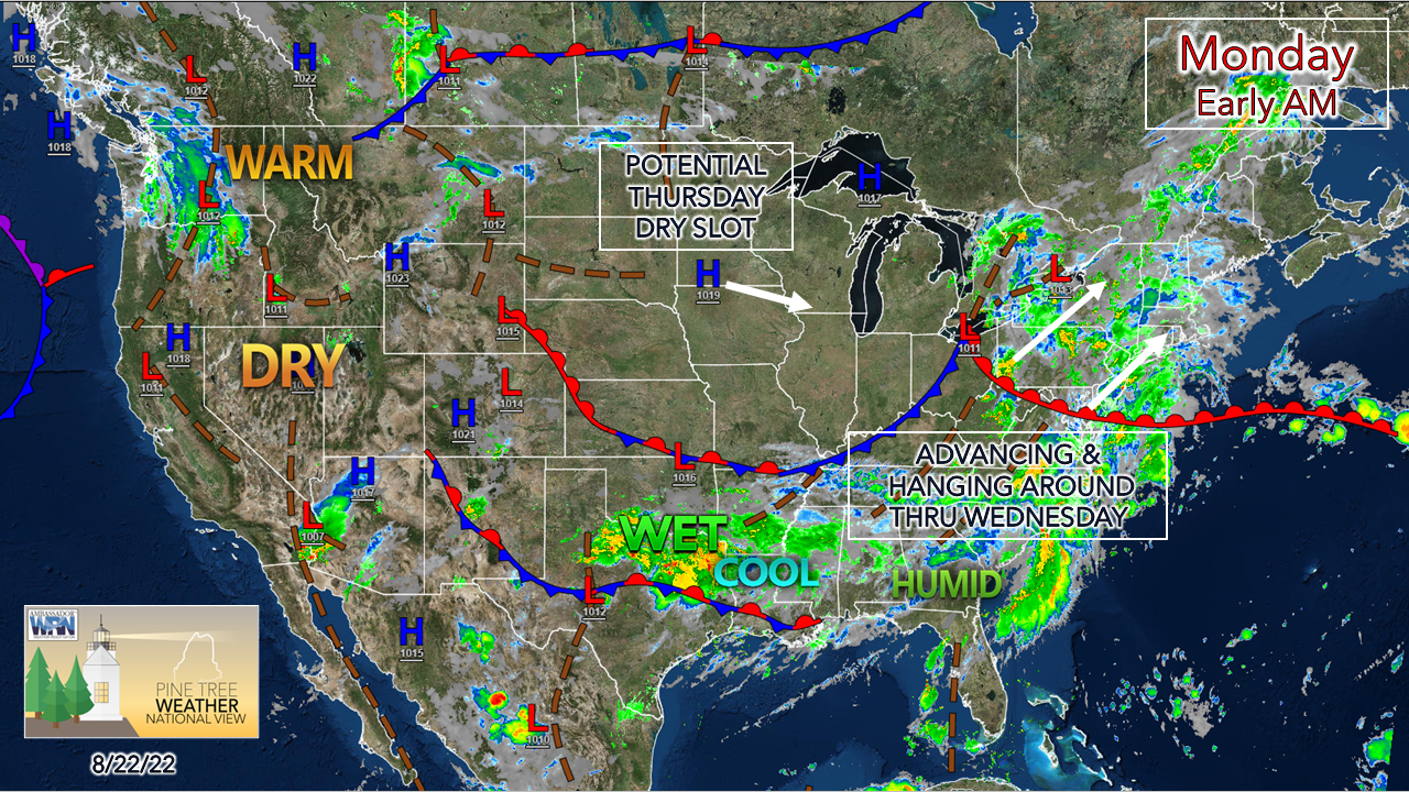 A warm front attached to an area of low pressure advances northeastward for Monday. A developing upper-level low over the Great Lakes works in behind the front and slowly spins its way through the region Tuesday into Wednesday, then fizzles out as it heads east into Thursday. Rain chances increase Monday afternoon Monday 11 AM to 11 PM - While the morning stays dry outside of some spotty drizzle associated with areas of fog around the region, the chances for rain increase through the afternoon into the evening for areas south of Jackman and Millinocket. Dew points will be on the increase through the day. I can't rule out the risk of a thunderstorm, but the chance is isolated. There could be periods of heavy rain as precipitable water values increase to 1½-2"+ with the moisture surge. 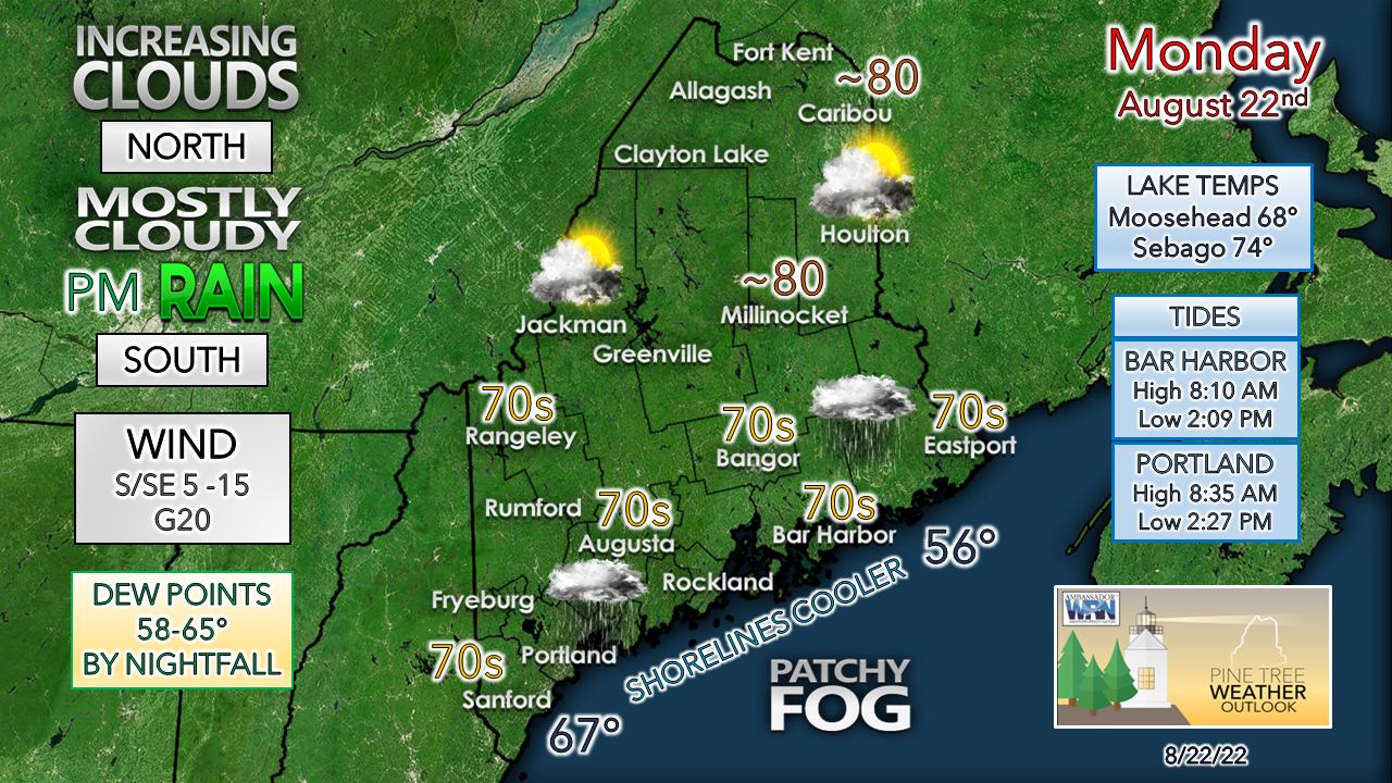 Northern areas are expected to see the most sun, although clouds will be on the increase. Fog is expected to be nemesis at times with the increasing dew points and the marine influence. A south/southeast wind flow assists to develop areas of dense fog and drizzle. Rockland may not make it to 70° with the fetch off the ocean. Rain showers continue into Tuesday Monday 11 PM to Tuesday 11 AM - The warm front pushes rain into northern areas by daybreak Tuesday. Much needed rainfall continues overnight for western, southern, and eastern areas. When the steady rain ends, expect areas of fog and drizzle as the warm sector settles in with stable air.  Tuesday 11 AM to Wednesday 2 AM - A cold front approaches from the west Tuesday afternoon. If the sun gets out, look out for potential storms that could contain torrential downpours and gusty wind, and perhaps some hail. As the upper-low driving the frontal boundary slowly advances eastward, showers become widely scattered into the overnight. Showers with the risk of a storm remain possible for Wednesday. Tropical activity expected to increase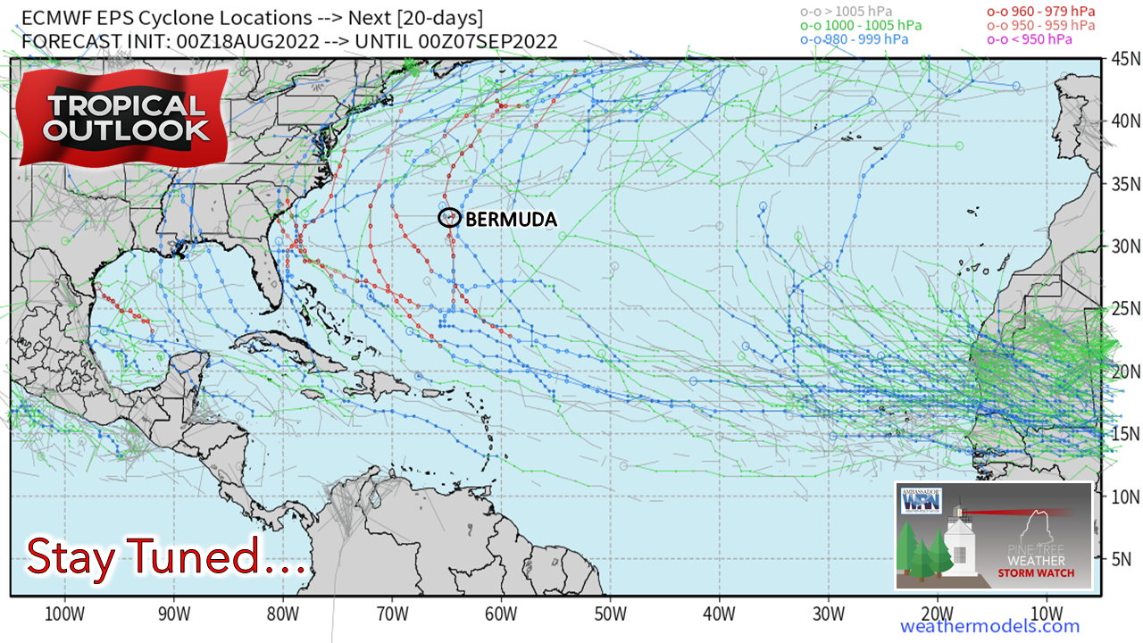 Seeing some deterministic ideas spinning up potential for tropical trouble and knowing the loops go viral on social media, I opted to share these ensemble ideas of what could happen. While it is science fiction for now, I am seeing signs that the Saharan Air Layer is tapering off with intensity, along with a drop of wind shear. The combination of those two key elements will allow for warm core storms to develop as the sea surface temperatures are ripe to create strong systems. I've mentioned the position of the Bermuda High in past updates, and I am going to continue monitor it as it is key factor in steering storms toward the east coast. It is the season, and it's important to stay updated on. Outlook through Saturday Wednesday 2 AM to Saturday 8 AM - Areas of showers are possible for Wednesday before a break in the action on Thursday. Guidance begins to stray with ideas heading into Friday regarding an approaching front. For now, I pencil in the chance for showers until guidance comes into better agreement on advancement and timing. The humidity is expected to break after the cold front passes through Friday night, and the weekend ahead appears dry and comfortable for now.  Thank you for supporting this community-based weather information source which operates by financial contributions from people like you. NEXT UPDATE: TUESDAY... HEALTH PERMITTING Stay updated, stay on alert, and stay safe! - Mike NOTE: The forecast information depicted on this platform is for general information purposes only for the public and is not designed or intended for commercial use. For those seeking pinpoint weather information for business operations, you should use a private sector source. For information about where to find commercial forecasters to assist your business, please message me and I will be happy to help you. |

Mike Haggett
|


