
A tricky forecast ahead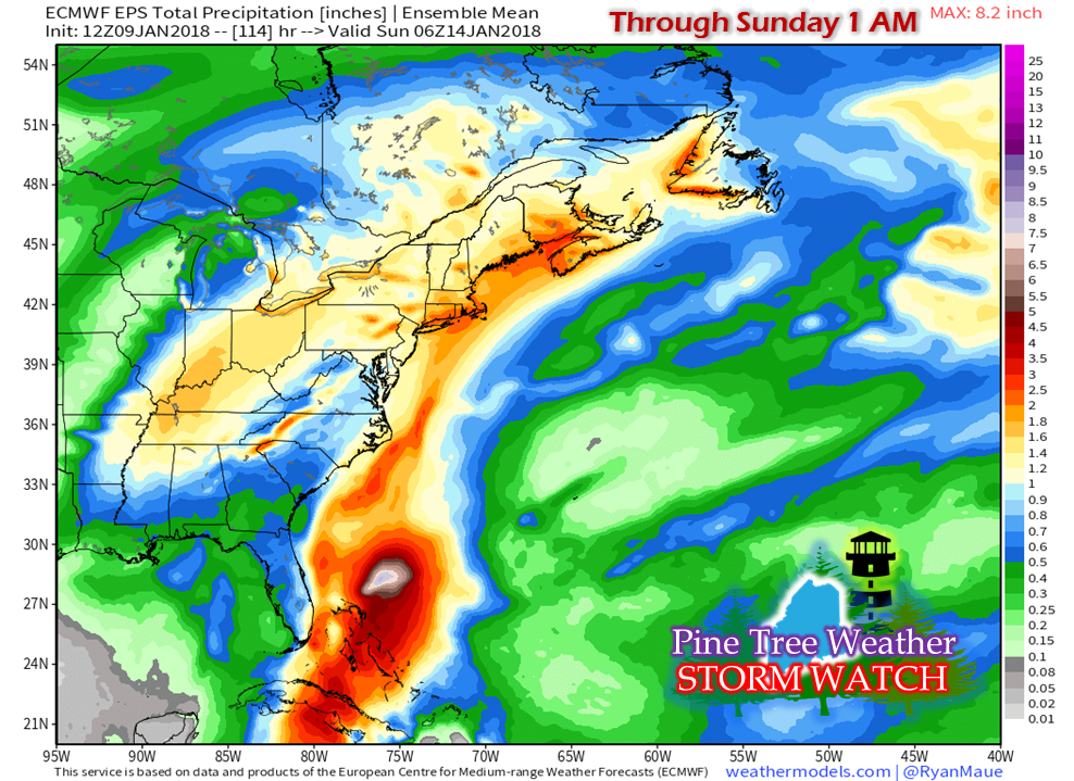 This discussion is purely on POTENTIAL as the players are still coming together and there is still some wiggle room going into the weekend. There is plenty to be concerned about here. First and foremost, is the amount of moisture associated with this frontal boundary. As you can see, the hose is attached from the southeast which will fuel into this. Between Wednesday night and early Sunday, the region is on track to get a healthy dose of it. This is the European model ensembles, which tends to be a bit on the juicy side. It suggests in this run that 1-2" of liquid equivalent precipitation is possible to come to the region. Given the recent snow, in conjunction with as cold as it has been, this likely going to pose some problems. 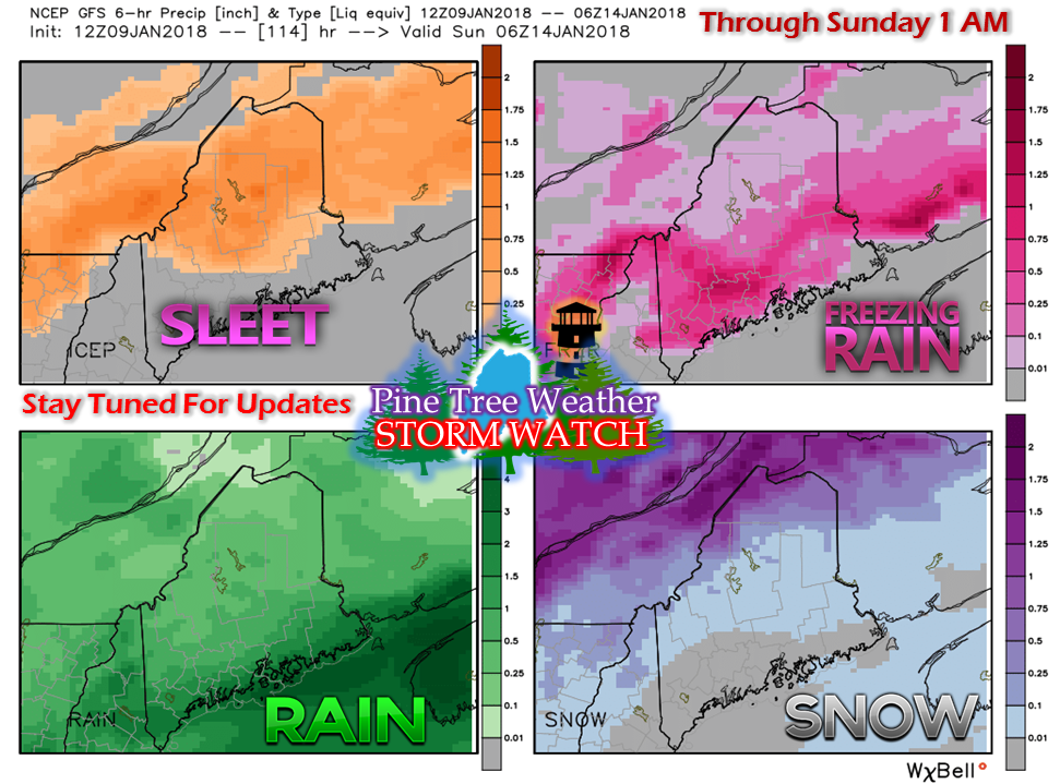 One blessing in all of this, not all the precipitation is likely to be liquid at landfall. As you can see, all four food groups above are in play here. My greatest concern at this point, is for southern and eastern areas, as most of the liquid appears to fall there. The warm up of Tuesday has allowed some snow to melt. While we cool a bit Wednesday, temperatures rise again for Thursday into Friday. With as cold as it has been, the ground cannot absorb any liquid. It will have to go somewhere. Storm drains. Ditches. Brooks, rivers and streams. With many of the tributaries frozen solid, runoff is likely to cause the potential for ice jams, which leads to flooding. Urban street flooding from clogged street drains are a possibility, also.
A rough guestimate is coastal areas will likely get half of the precipitation in the form of liquid. Based on the European ensemble idea, that would mean roughly an inch. That is enough to not only cause flood potential, but also problems with unshoveled roofs of houses and buildings. It is too early to tell if the mountains and north will be able to escape this. Guidance is playing around with several scenarios involving the position of the front and intensity of the developing low along it. The model runs of Wednesday morning and evening will help narrow down the track of the low forming along the front, where the cold air to the north and west will set up and how much cold air damming at the surface this will cause for Saturday. For now, if you are reading this from Seacoast New Hampshire or in the heart of the Allagash, be prepared to see ALL forms of precipitation between Friday night through Sunday morning. As I have said before, many things have to go right for freezing rain to occur. The question at this point is does the cold arrive in time at the surface to make that happen. Usually, the cold air is already here when warm air invades aloft. This is a scenario where cold air bleeds into the surface with warm air already being here to begin with. If you have plans for the weekend to travel, even if it is to run simple errands around town, you'll want to stay updated on this forecast. This is all low confidence on just how it will all play out, but confidence is high that the entire state will have to deal with some amounts of rain, freezing rain, sleet and/or snow between Wednesday night and Sunday, with Saturday being the potential ice concern. Stay tuned. - Mike |

Mike Haggett
|


