Pine Tree Weather
  • DISCUSSIONS
  • DONATE
  • WEATHER WALL
  • MAPS
  • RAIN OUTLOOK
  • SEVERE
  • MARINE
  • CPC OUTLOOK
  • Kennebunk
  • MY BIO
  • PTW IN MEDIA
  • OBSERVING WEATHER
  • INTERNSHIPS
  • INTERN ALUMNI
  • DISCUSSIONS
  • DONATE
  • WEATHER WALL
  • MAPS
  • RAIN OUTLOOK
  • SEVERE
  • MARINE
  • CPC OUTLOOK
  • Kennebunk
  • MY BIO
  • PTW IN MEDIA
  • OBSERVING WEATHER
  • INTERNSHIPS
  • INTERN ALUMNI

Upper-low continues to spin through Maine Tuesday

10/19/2021

Comments


Clouds, chance for showers, and breezy

Picture
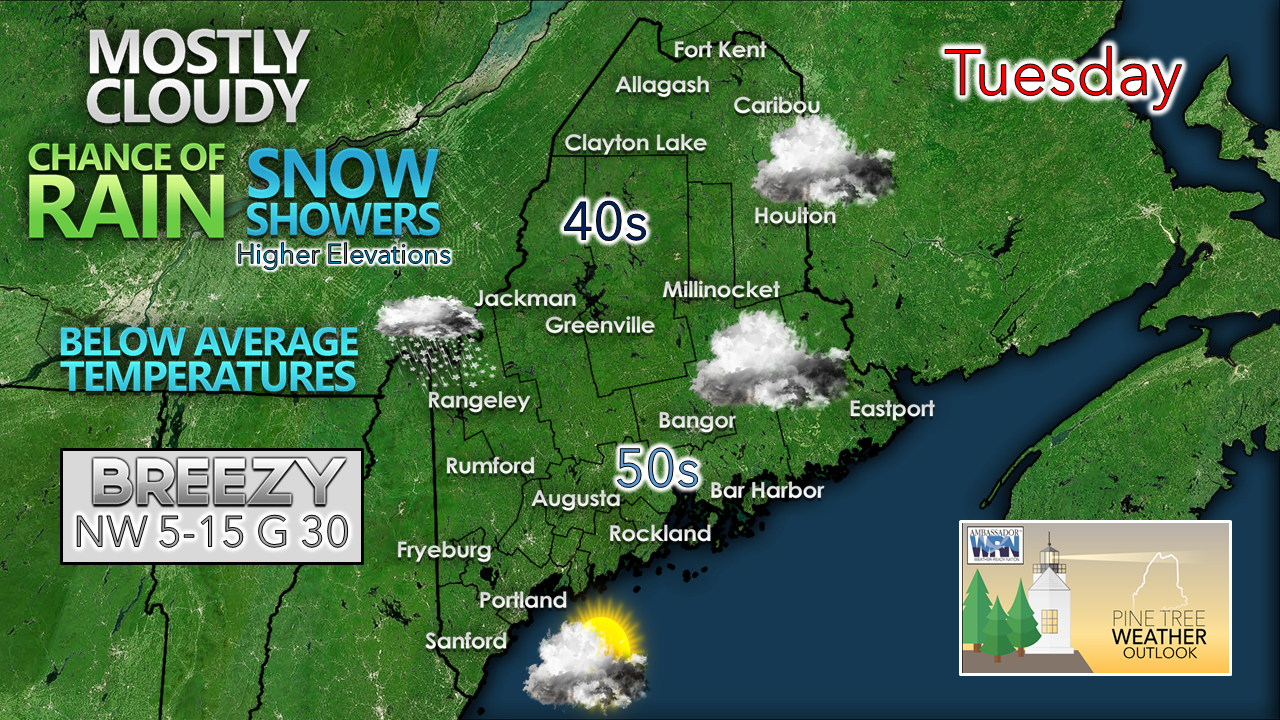
To sum up the day in a nutshell, it will be a raw one. As the upper low continues to spin overhead, it will bring in cooler air thanks to a northwesterly breeze, mainly cloudy skies for all but southern areas, along with a chance for precipitation.
Picture
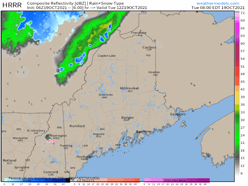
Tuesday 8 AM - 8 PM: As shortwaves pass through the area, those will bring the best chance for precipitation. The mountains and north have the best chance to get shower activity. In areas in elevation 2,500' and higher have the best chance for some light accumulations of snow.
Picture
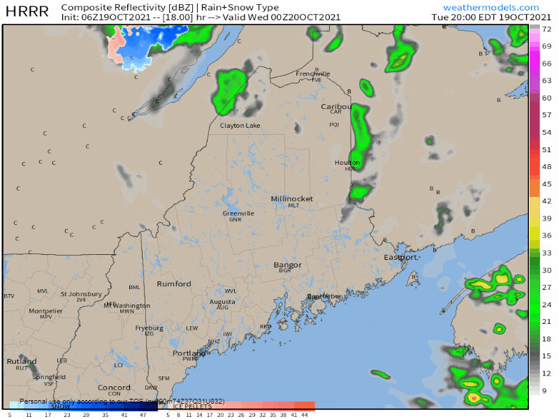
Tuesday 8 PM - Wednesday 8 AM: Another shortwave is expected to pass through the region overnight as the upper-low begins to move to the northeast. This again will bring a chance for precipitation over the state in the overnight hours into Wednesday morning. For those in the mountains, there is a possibility for some slick roads in the higher elevations through mid-morning. 

Picture

Outlook for the rest of the week and weekend

Picture
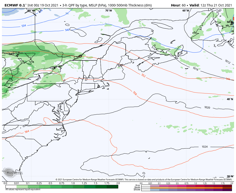
Thursday 8 AM - Friday 8 PM: A weak area of high pressure moves in on Wednesday for a brief visit, and then departs to the east. A frontal boundary approaches from the west heading into Thursday. Low pressure is expected to form along the front and ride up through the St. Lawrence River valley and bring the chance for rain showers for the north and mountains Thursday afternoon into Friday. A cold front is expected to pass through the region, which may bring an isolated shower to the coastal plain Friday afternoon. 
Picture
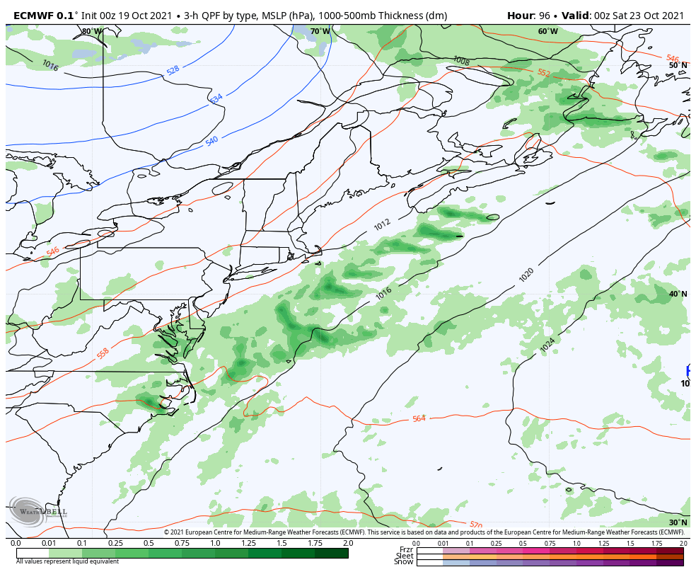
Friday 8 PM - Sunday 8 PM: The weekend forecast is a toss-up at this point. The cold front that passes through the region is expected to stall offshore, but the main question for now is where. Model ideas vary in solutions. At this point, coastal areas have the best chance for showers on Saturday, but if the front stalls over the Gulf of Maine, all areas could see a showers to start the weekend. It is wait and see as to how this plays out for now. 

Temperature outlook through Sunday

Picture
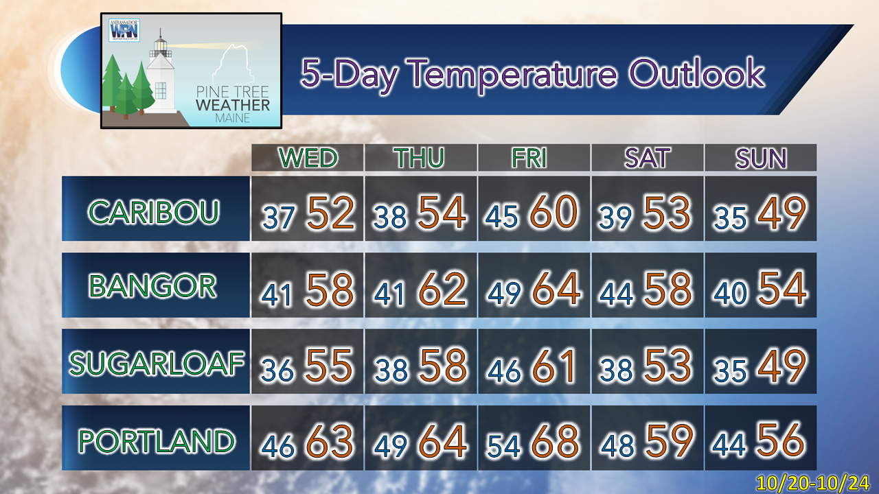
The thermometer is expected to be on a bit of a roller coaster going into the weekend. Temperatures progressively warm up through late week, and then cool down heading into next week. The mean average over the next five days is slightly above normal. 

mPING your weather observations!

Picture
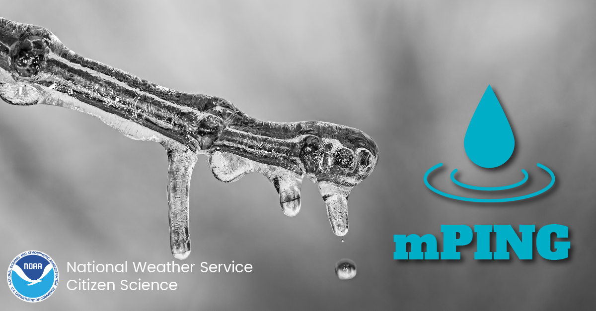
Check out mPING (Meteorological Phenomena Identification Near the Ground) project. Weird name, cool app! You can report the type of precipitation you see where you are. No need to measure! Use the free mobile app to send reports anonymously. Reports are automatically recorded into a database, which improves weather computer models.  mping.nssl.noaa.gov

Be prepared to receive alerts and stay updated!

Picture
​BE PREPARED WITH A NOAA Weather Radio.
​
​For $20-$40, it could provide vital information to you when you need it. The weather bands are standard on most public safety scanners, and newer scanner models. Weather radios can be programmed for auto alert. Click here for more information.

​​​​​​​​► ► For the latest official forecasts, bulletins, and advisories, please check in with the National Weather Service in Gray for western and southern areas, or Caribou for northern and eastern parts of Maine.
Picture

Picture
For more information in between posts, please follow Pine Tree Weather on Facebook and Twitter. 

​Thank you for supporting this community-based weather information source which operates by reader supported financial contributions. 

Stay updated, stay on alert, and stay safe!

​- Mike
Comments
    Picture

    Mike Haggett
    Kennebunk, ME

    Weather-Ready Nation
    Ambassador

    Certified Weather
    Forecaster
    Penn State '21

    American Meteorological Society

    National Weather Association
    ​
    ​SKYWARN-CWOP

    Matthew 19:26


    DONATE

    Picture
    Picture
    Picture
    Picture
    Picture

    Picture

    Picture

    Picture

    Picture

    Picture

    Picture

    Picture

    Picture

    Picture

    Picture

    Picture

    Picture


    Archives

    May 2025
    April 2025
    March 2025
    February 2025
    January 2025
    December 2024
    November 2024
    October 2024
    September 2024
    August 2024
    July 2024
    June 2024
    May 2024
    April 2024
    March 2024
    February 2024
    January 2024
    December 2023
    November 2023
    October 2023
    September 2023
    August 2023
    July 2023
    June 2023
    May 2023
    April 2023
    March 2023
    February 2023
    January 2023
    December 2022
    November 2022
    October 2022
    September 2022
    August 2022
    July 2022
    June 2022
    May 2022
    April 2022
    March 2022
    February 2022
    January 2022
    December 2021
    November 2021
    October 2021
    September 2021
    August 2021
    July 2021
    June 2021
    May 2021
    April 2021
    March 2021
    February 2021
    January 2021
    December 2020
    November 2020
    October 2020
    September 2020
    August 2020
    July 2020
    June 2020
    May 2020
    April 2020
    March 2020
    February 2020
    January 2020
    December 2019
    November 2019
    October 2019
    September 2019
    August 2019
    July 2019
    June 2019
    May 2019
    April 2019
    March 2019
    February 2019
    January 2019
    December 2018
    November 2018
    October 2018
    September 2018
    August 2018
    July 2018
    June 2018
    May 2018
    April 2018
    March 2018
    February 2018
    January 2018
    December 2017
    November 2017
    October 2017

Proudly powered by Weebly