
Showers with isolated storms for Friday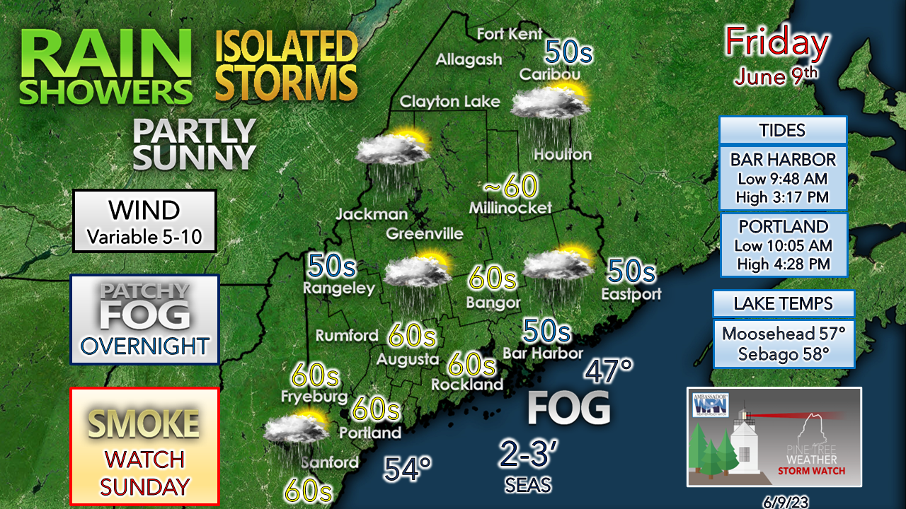 The main concern of impact through Sunday morning is the risk of fog popping up in areas of late afternoon rain, and along the DownEast shorelines. The fog could be locally dense in spots. The storm risk is minimal and sun dependent through the afternoon. I am not expecting severe, but with any storm I expect a puff of wind and small hail, along with a brief power wash. 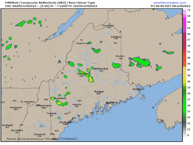 Friday 6 AM to Saturday Midnight - Day 7 of this upper low is similar to what the region experienced on Thursday. After a fairly quiet morning, the heating of the atmosphere turns on the popcorn machine, and showers form and percolate through early evening. Once the sun sets and the atmosphere cools, an isolated shower is possible in spots overnight. The best chance for a thunderstorm will be for southwestern areas. Looking ahead to Saturday, it's the same idea, with a bit more of a risk of isolated thunder across the state. Smoke and the upper-level pattern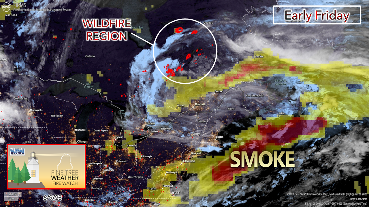 For the past few days, the smoke from the wildfires in the Abitibi region of Quebec has been the main news story over the northeastern United States. This graphic shows the dynamic set up as to why Maine has been sheltered from it during the worst of it, and that is because of the upper-low that has anchored overhead. Given the fact there has been no forcing in the atmosphere due to the blocking and no mixing of wind to stir it upwards, that is a short explainer as to why that happened. That is about to change.  Friday 8 AM to Sunday 8 PM - This is the forecast of the 500mb (altimeter ~18,200 ft) steering level of the atmosphere. An upper-low spins up over the Pacific northwest on Friday and drops south on Saturday. This is the kicker that agitates the ridge over the Rockies, nudges the upper-low in the Arctic and thus moves the upper-low that has been over Maine out of the area Saturday night. With the shift in the pattern, the wind direction over the burn areas does shift southeastward with the exit of the upper-low. With the wind stirring up on the backside of the upper low, this won't allow the smoke to hug the surface, thus keeping it higher in the atmosphere. As I mentioned Thursday on Facebook, I do not expect anything like what was experienced by our neighbors to the southwest. I do expect a dimming of the sky, which may bring a vivid sunset Sunday night. I do not expect any major concerns with air quality, and the stash of N95 masks can stay where they are. Please do note two things late in the loop. First, a new upper low over the Great Lakes spins up, which will bring showers and storm potential Monday night through Wednesday. Also note the upper low over the southwest as that may impact next weekend. Temperature outlook through WednesdayAfter the showers and storms clear out Saturday, areas of fog are possible to start Sunday but should burn off by mid-morning and bring the best day the region has had in the past nine days. Temperatures feel like summer on Monday before rain returns Tuesday and Wednesday. 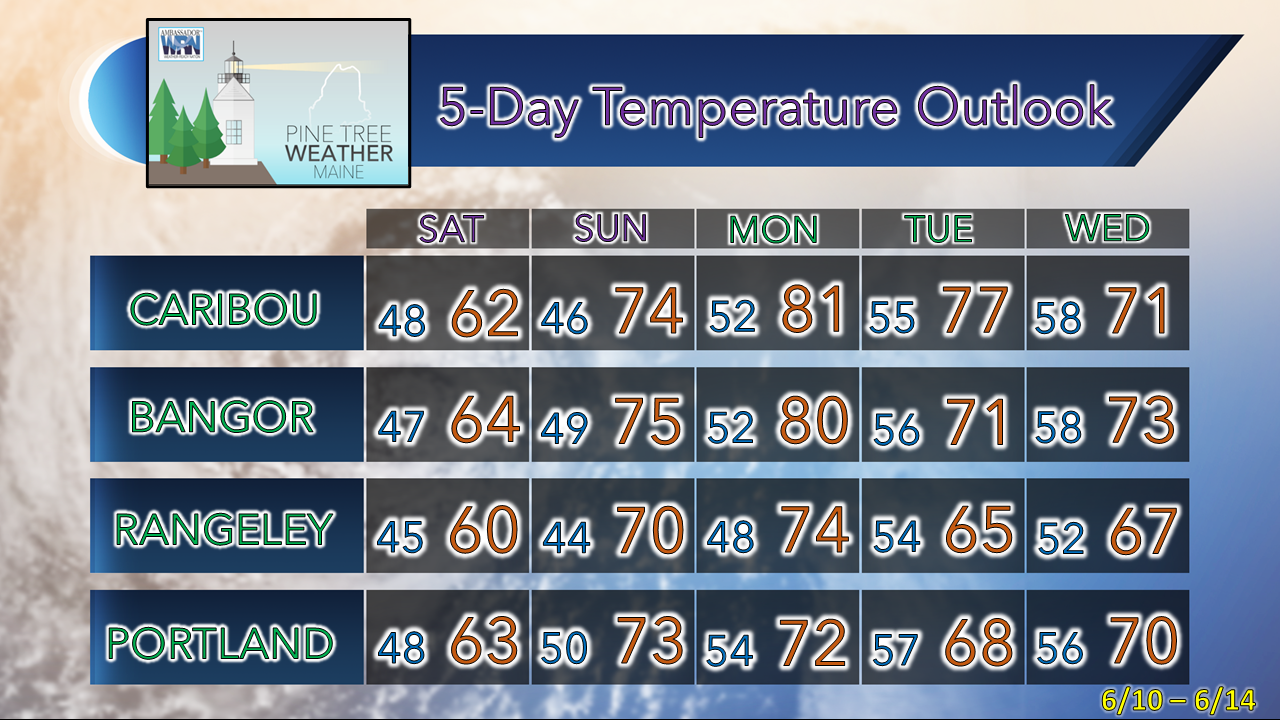 Pine Tree Weather is funded from followers like you. I would appreciate your financial support. Click here for how you can contribute. You may not like the weather, but I hope you like what I do! Please hit the like button on Twitter and Facebook, and share! I sincerely appreciate your support! Stay updated, stay on alert, and stay safe! - Mike NOTE: The forecast information depicted on this platform is for general information purposes only for the public and is not designed or intended for commercial use. For those seeking pinpoint weather information for business operations, you should use a private sector source. For information about where to find commercial forecasters to assist your business, please message me and I will be happy to help you. |

Mike Haggett
|


