
A weak wave passes over northern areas Thursday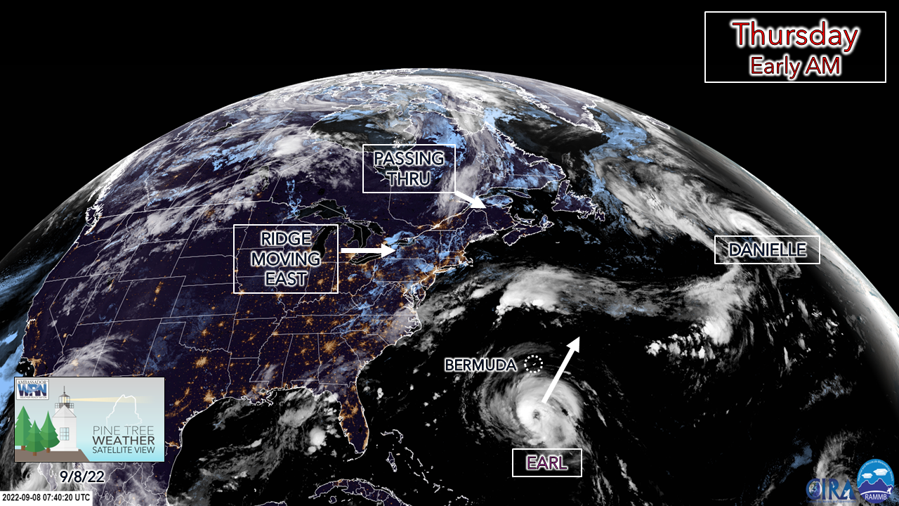 While the weather pattern over the region appears quiet over the next several days, there is activity offshore that will be interesting to watch. The eyewall of Earl is clearing out as it strengthens to a major hurricane and will be a darling to see on satellite as it heads northeast. For Thursday, a weak cold front passes through northern areas for the day, which will likely be the last chance for rainfall anywhere until the middle part of next week. 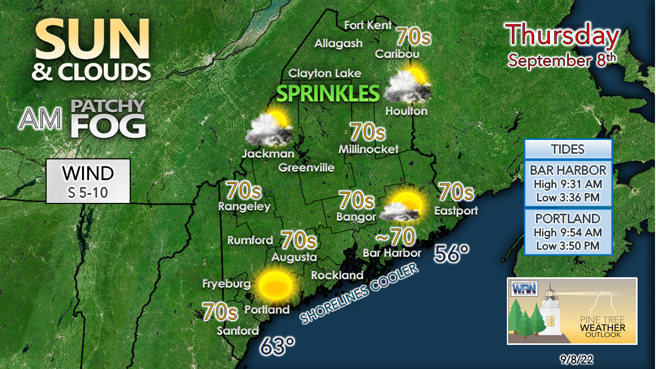 What rain comes from it is expected to be minimal. The chance for a sprinkle in the mountains and north outweighs the risk of an isolated light shower. The better chance for that is further north. Southern areas bask in the sun after any early morning fog burns off, with temperatures a bit on the cool side for September 8th statewide. The pattern, Earl, and surf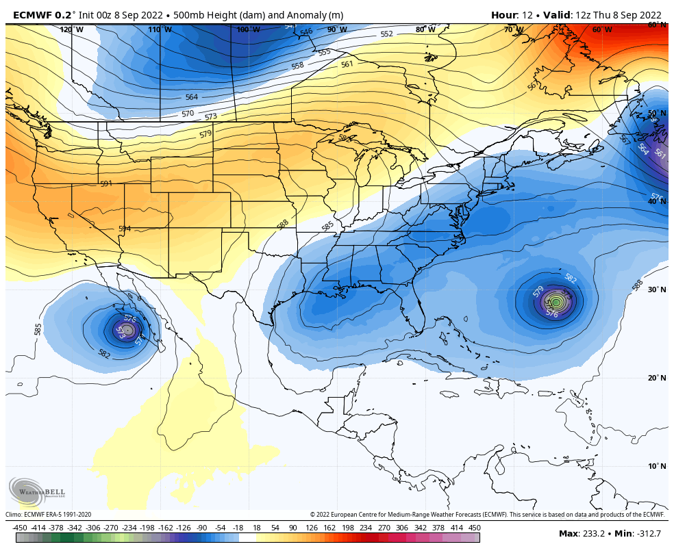 Thursday 8 AM to Tuesday 8 PM - A look at the 500mb steering level outlook at roughly 20,000 feet shows the ridge building in from the northeast, the wave passing through the region Thursday amplifying which is keeping Earl well away from the area. The ridge begins to break down slowly to start next week. An upper spins up over the Canadian Prairies and heads for the Great Lakes and will be the next feature to watch for potential rain chances Tuesday into Wednesday. 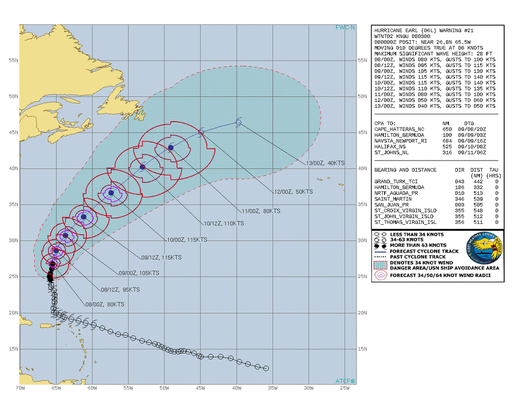 The track and forecast of Earl seen here as of 8 PM Wednesday shows the storm picking up the amplified wave and keeping it well to the east. After it passes Bermuda, the timing of the interaction with the wave determines if Newfoundland gets brushed with a bit more than just surf. The hurricane is expected to maintain major hurricane status as it passes through 35°N latitude, maintain CAT 2 status as it passes due east of Maine Saturday night and east of Nova Scotia on Sunday, before expanding and becoming extratropical Monday into Tuesday.  The forecast low level wind field of Earl with NOAA's HWRF hurricane model shows a CAT 2 status storm with an eye wall transitioning from a warm core tropical system to a cold core extratropical system as it passes due east of Maine well out to sea Saturday night. The wind field expands at higher latitudes, which in this case the model is showing that taking place. The development of Danielle in higher latitude and the strength of Earl at this level takes the thoughts of this forecaster back to Gloria in 1985 that made landfall over southern New England as a CAT 2 storm. Given the 80°+ sea surface temperatures offshore currently, it's fuel for warm core systems to maintain strength. It definitely raises the left eyebrow high thinking of what would happen if the region was faced with that potential again. While no threat is imminent or forecast, with plenty of time left in the tropical storm season, it's a good idea to check storm supplies and generators this weekend for potential of strong ocean storms as we head into fall. 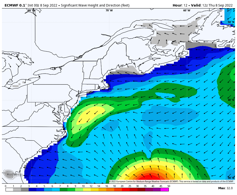 Thursday 8 AM to Tuesday 8 AM - A look at one wave height and direction model idea shows the potential for seas 50'+ feet in the eye of Earl as it passes northeast. For Maine. the idea of 3-4' long wave swells from the storm is the thought for now and may bring a high surf advisory over the weekend if the wave heights are predicted to go higher, which is possible. The ocean may not settle down until Monday. It will be a surfers joy, and with the weekend shaping up to be a decent beach goer affair, the idea of rip currents may be a concern for the swimmers. 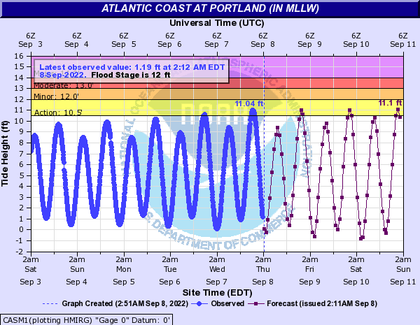 With tides astronomically high with the full moon, there is potential for splash-over and minor flooding with the higher evening tides over the weekend, with the swells from Earl increasing the possibility of coastal flood statements for MidCoast and southwest coastal areas. Temperature outlook through TuesdayAll in all, a beautiful stretch of weather with comfortable humidity levels and above normal temperatures overall through the first of next week. 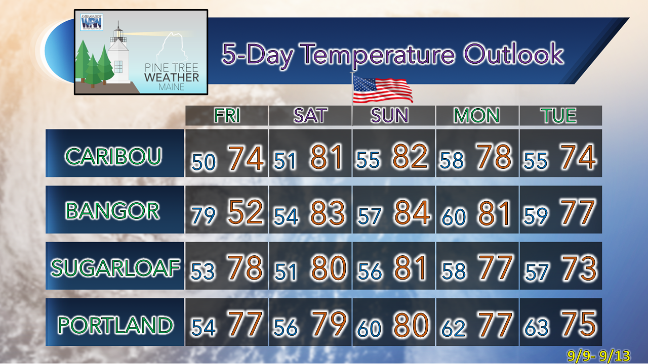 Thank you for supporting this community-based weather information source which operates by financial contributions from people like you. NEXT UPDATE: MONDAY, IF NOT BEFORE Stay updated, stay on alert, and stay safe! - Mike NOTE: The forecast information depicted on this platform is for general information purposes only for the public and is not designed or intended for commercial use. For those seeking pinpoint weather information for business operations, you should use a private sector source. For information about where to find commercial forecasters to assist your business, please message me and I will be happy to help you. |

Mike Haggett
|


