Pine Tree Weather
  • DISCUSSIONS
  • DONATE
  • MAPS
  • NWS BRIEFINGS
  • SATRAD
  • MARINE
  • SNOW / ICE OUTLOOK
  • RAIN OUTLOOK
  • CPC OUTLOOK
  • Kennebunk
  • OBSERVING WEATHER
  • Who We Are
  • My Photography
  • DISCUSSIONS
  • DONATE
  • MAPS
  • NWS BRIEFINGS
  • SATRAD
  • MARINE
  • SNOW / ICE OUTLOOK
  • RAIN OUTLOOK
  • CPC OUTLOOK
  • Kennebunk
  • OBSERVING WEATHER
  • Who We Are
  • My Photography

Weather pattern to become more active heading into the weekend

11/9/2021

Comments

 
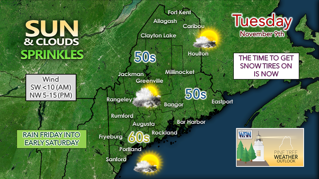
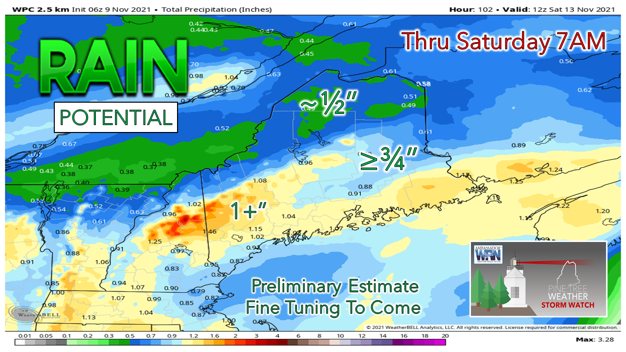
I had to take a bit of a break from website updates to recharge my batteries a bit. I will be honest, I am fighting fatigue from the stressors of the day job, the early mornings to forecast and the rest of life I have going on. I am evaluating what I do here as I know I cannot sustain short nights as well as I used to. I want to produce a useful product that has value to you but may do so in a more compact version. Rest assured when storms come, I plan on being there to give you the information you need.

I am in the process of raising funds for 2022. I need your help to pay the bills and make the sacrifices on sleep worth it for me. A few folks have pitched in already, which I appreciate. I want to specifically thank my Patreon followers who give me a backbone of monthly support which I can base a solid portion of my operating budget. Right now, my deficit for the year is $1700. Whether $5 a month on Patreon or $50 through VENMO or whatever you can spare, I would really appreciate the help. Nothing boosts my confidence more than knowing you have my back through your financial donations and shares of my work with others. For ways to support, click on the banner below or the DONATE tab for more information. 

A weak front for Tuesday;
stalled boundary brings showers Tuesday night into early Wednesday

Picture
Northern and southern areas have the better chance to see the most sun for the day. A weak frontal boundary passes through the region and may bring a sprinkle to the higher elevations around midday. A shift in the wind to the northwest brings the warmest temperatures to the coast for the afternoon. Sixty degree or higher temperatures appear likely to become a rare commodity going forward. 
Picture
Tuesday 8 PM - Wednesday 1 PM - The weak front that passes through the region Tuesday stalls to the south. A weak area of low-pressure rides along it and may bring some light rain or snow showers to the region Tuesday night into Wednesday morning. Accumulations are expected to be light, with perhaps a dusting of snow for the higher hilltops. 

Next storm late week

Picture
Tuesday 7 PM - Saturday 1 PM - Colorado low season is in high gear. A shot of cold air from western Canada meets up with a forming frontal boundary just east of the Rockies and spins up a decent storm over the Midwest Wednesday into Thursday. An upper-level low captures the surface low Thursday night and weakens the storm on Friday. The timing of this occlusion is important to factoring precipitation amounts for the state Friday afternoon into early Saturday.
Picture
As the surface low intensifies, it taps into Gulf moisture and hauls it northeastward. A short kiss of the stream could bring spurts of heavy rain into the region Friday night.
Picture
Given the south / southeast wind flow with the frontal boundary, the western mountains and foothills could do well for rainfall amounts. The storm could bring some needed rainfall to the Rangeley Lakes region, but the higher hills may keep those areas a bit drier. Far northern areas may get clipped with snow or mixed precipitation as the storm departs Saturday morning.

The weekend looks like a 50/50 split, with Saturday being the better of the two days. A slow moving upper low to the north pinwheel's disturbances through the region Sunday and into early next week. 

Picture

Temperature outlook through Sunday

The normal high and low for Caribou is 42° / 28°. For Portland, 51° / 34°. Temperatures are expected to run above normal overall through the weekend. 
Picture

Snow watch

Picture
Seeing the cooler trend ahead gives validity for a chance for snow for the mountains heading toward the middle part of next week. Stay tuned for more on that as we get closer.

Be prepared to receive alerts and stay updated!

Picture
​BE PREPARED WITH A NOAA Weather Radio.
​
​For $20-$40, it could provide vital information to you when you need it. The weather bands are standard on most public safety scanners, and newer scanner models. Weather radios can be programmed for auto alert. Click here for more information.

​► ► For the latest official forecasts, bulletins, and advisories, please check in with the National Weather Service in Gray for western and southern areas, or Caribou for northern and eastern parts of Maine.
Picture

Picture
For more information in between posts, please follow Pine Tree Weather on Facebook and Twitter. 

​Thank you for supporting this community-based weather information source which operates by reader supported financial contributions. 

Stay updated, stay on alert, and stay safe!

​- Mike
Comments
    Picture

    Mike Haggett
    Kennebunk, ME

    Certified Weather
    Forecaster
    Penn State '21

    American Meteorological Society

    National Weather Association

    Weather-Ready Nation 
    Ambassador
    ​
    ​SKYWARN-CWOP

    Matthew 19:26


    Support
    Pine Tree Weather

    DONATE

    Picture

    Picture

    Picture

    Picture

    Picture

    Picture

    Picture

    Picture

    Picture

    Picture

    Archives

    January 2023
    December 2022
    November 2022
    October 2022
    September 2022
    August 2022
    July 2022
    June 2022
    May 2022
    April 2022
    March 2022
    February 2022
    January 2022
    December 2021
    November 2021
    October 2021
    September 2021
    August 2021
    July 2021
    June 2021
    May 2021
    April 2021
    March 2021
    February 2021
    January 2021
    December 2020
    November 2020
    October 2020
    September 2020
    August 2020
    July 2020
    June 2020
    May 2020
    April 2020
    March 2020
    February 2020
    January 2020
    December 2019
    November 2019
    October 2019
    September 2019
    August 2019
    July 2019
    June 2019
    May 2019
    April 2019
    March 2019
    February 2019
    January 2019
    December 2018
    November 2018
    October 2018
    September 2018
    August 2018
    July 2018
    June 2018
    May 2018
    April 2018
    March 2018
    February 2018
    January 2018
    December 2017
    November 2017
    October 2017

    RSS Feed

Proudly powered by Weebly