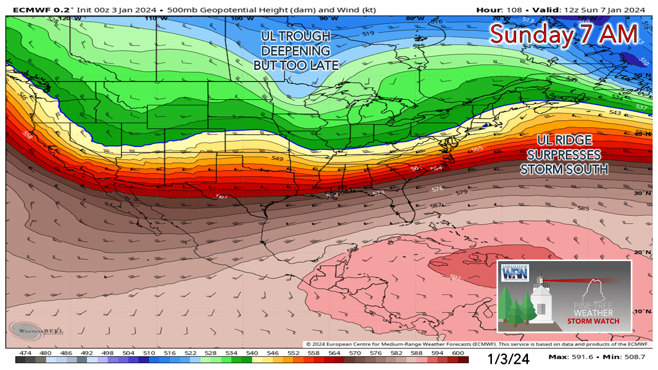
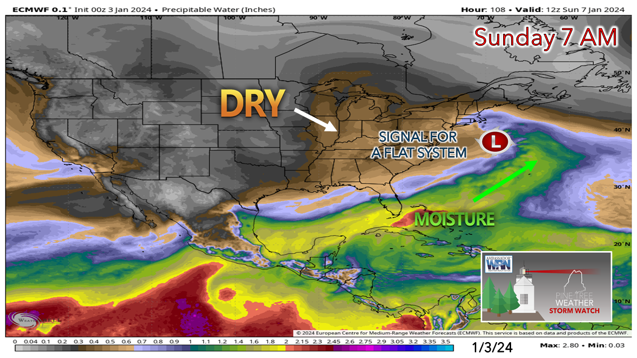
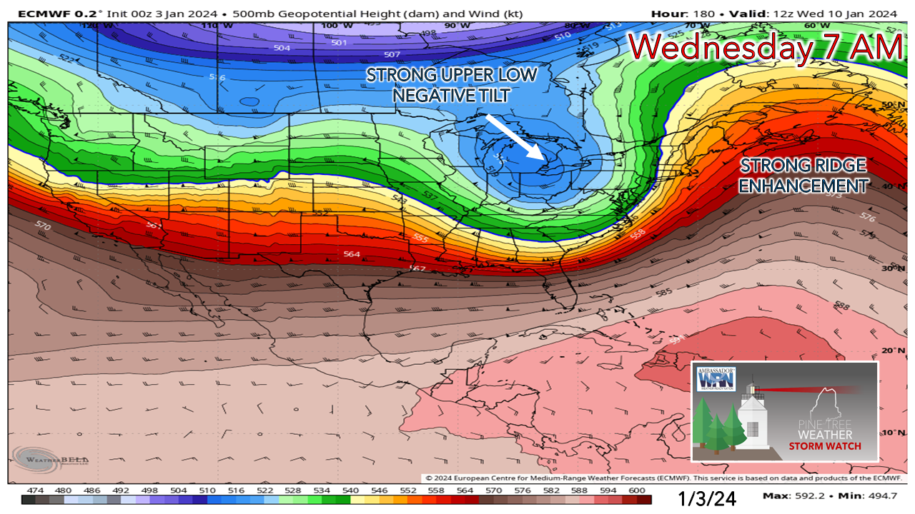
Waves passing throughThe mountains and Quebec border region up into the Allagash should fare well over the next couple of days with some fluff and could pick up 2-4" of it as two upper level waves pass through. A bit of interaction is possible with the storm over the southeast and the Thursday wave may bring snow showers to a good portion of the area, which may cause a few slick spots, but not enough to plow or shovel over much of the region. After the Thursday wave passes through, the northwest wind picks up overnight into Friday morning. Expect face numbing wind chills to start the day, with the air conditioner fan gradually subsiding through the day. High pressure settles in by Saturday, which will be the table setter for some snow potential Sunday, Two different storm systems on the wayI mentioned on Twitter / X on Tuesday that I am having a hard time getting fired up about snow potential for Sunday. While reviewing overnight ideas, I still feel that way. The storm potential for Tuesday into Wednesday has certainly raised an eyebrow and is a cause for wider scale impacts and concerns. First, a look at Sunday. The ensemble ideas that are out there are indicating a relatively weak system with the larger number of individual members lagging to the south of the benchmark "B" which is 40° north latitude / 70° west longitude south of Nantucket which is the reference point that NorEasters remain snow for the coastline. The cold air will be around. I will say that the 41° ocean temperature also has my attention for a potential mix for the southwest coast, as warmer air off the water may try to throw a wrench into snow potential for shoreline communities. The other wrench in this is the upper level ridge that the storm is tracking into. Part of the reason why the bulk of the ensemble ideas are south of the benchmark point is because of that. The ridge acts as a barrier and push the system to the south. That is the forecast trend as of now. The moisture stream is way to east with this model idea. Dry air to the north associated with high pressure is locked in with this solution. Respecting cold, low dewpoint air for what it is, any moisture thrown into it evaporates. Southern and shoreline areas up the coast have the best chance for snowfall. It's not fair at this point to speculate how much given the wiggle room of potential. It will depend on track and intensity. Given the flat nature and the more southerly track the guidance is showing at this point, I don't see this storm to be a big deal. It could be a few inches of snow, or snow showers. We'll see. The storm potential for Tuesday into Wednesday is a different animal. With the storm a week out at this point and with the key energy source nearing Japan, there is plenty of room for changes here. There are some similarities with forecast intensity that was experienced with the storm before Christmas. A strong high to the east with a deep low generating to the west and slamming into it. The track idea is different. While an inside runner, the track on this one is more to the northeast at this point, rather than due north like the storm in December. This opens the door for cold air to be more of a player, and if that idea continues, more of a snow event for the interior. The December storm central pressure came through New Hampshire at around 975mb. That is the rough idea that is out there on this one. Unlike Sunday's storm, the general idea on this one is much more amplified, and thus more impactful over a wider area. A sharp negative tilt fires a strong surface low, with a bombogenesis cyclone a distinct possibility. A more defined moisture hose is the potential with this one. With that comes a strong low level jet feeding into it, which brings concerns for strong wind, which with heavy snow potential over the interior would be problematic. The ground is frozen everywhere at this point, which presents a flooding concern where rain falls. Tides will be astronomically high, which brings concern for another shoreline assault. Whether or not this comes to fruition is yet to be seen, but you are on notice of the potential for it. Keep the storm supplies stocked and fuel for the generator filled. Please support my effortsThank you to Allspeed Cyclery & Snow in Portland, Downeast Aerial Photography in Rockland, Dutch Elm Golf Club in Arundel, and Sunrise Property Services in Bridgton, for partnering with Pine Tree Weather. Special thanks to all the individuals who financially contribute. I sincerely appreciate your support. Stay updated, stay on alert, and stay safe! - Mike PRINT MEDIA: Feel free to quote and cite my work here for your stories. Please give me the professional courtesy of knowing that you are referencing my material so I can read your final product and acknowledge it on my media and link it on the Who I Am page here on the website. Feel free to send me a message via the Facebook page or Twitter (X) to get my phone number if necessary. Thank you! NOTE: The forecast information depicted on this platform is for general information purposes only for the public and is not designed or intended for commercial use. For those seeking pinpoint weather information for business operations, you should use a private sector source. For information about where to find commercial forecasters to assist your business, please message me and I will be happy to help you. |
Mike Haggett
|


