
Flooding concerns for late week continue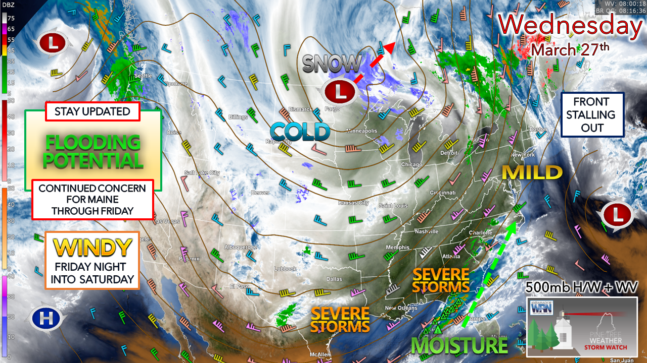 A look at the 500mb steering level of the atmosphere at roughly 20,000 feet shows the setup with the height contours (lines) and wind speed, along with a satellite water vapor view. The tightening of the contours over the east shows the friction between the upper low over Minnesota, the cut-off upper low over Bermuda, and a strong ridge sandwiched in the middle. Severe storms over the southeast were active overnight, with the triangles indicating hail. This moisture feed shoots up the eastern seaboard to bring the flood potential rainfall on the way to the region Thursday into Friday.
The question remains as to where the front ultimately stalls out and the timing of the development of the surface low in conjunction with it. While eastern Maine will likely get the most rainfall (2-3”+), confidence remains low on how much liquid the rest of the region receives. With the snowpack ripening due to the mild conditions, runoff is inevitable, but to what extent is still difficult to figure out for the west and north. Given the ideas on upper-level wind direction, short-term guidance at this early stage of Wednesday morning appears to spare the western mountains from the onslaught of taking a direct hit from the moisture shield. This is good news for ski country. That said, orographic lift (air forced over higher terrain) is still a player and could bring 1-2”+ of rainfall there, with less to the north along the international border with Quebec. A ripening snowpack with above 32° dew points and fog will eat away at it. With the current snowpack, it can handle up to 1½” of rainfall before flood concerns become elevated. REMEMBER: there is roughly 1½-2” of water content in every foot of snow that is present there. As the snowpack ripens, it will melt and seek escape through brooks, streams, small rivers, and basements. Eastern areas are at the highest risk for flooding, with MidCoast, southern Aroostook, and the Penobscot River basin (Bangor) certainly on the discussion board. To the west, I suspect the Swift and Carrabassett Rivers may reach flood stage. The Piscataquis and Mattawamkeg also have a fair chance of reaching the flood stage. Downstream concerns for the majors (Androscoggin, Kennebec, Penobscot) are a wait-and-see situation. Expect rises, at the very least, with impacts to be determined. Also, here is a heads-up for the Saint John region as NWS Caribou expects the ice to move along, which may jam and cause flooding. For areas along the coastal plain, what snow you see is likely to wash away for the most part, other than some of the taller snowbanks. There could be some nuisance flooding in low-lying areas, with the potential for localized flash flooding with downpours. Sensitive basements may have issues. The heaviest rainfall is expected to occur Thursday into Friday morning. Precipitation is expected to end from west to east on Friday. I suspect a flood watch will come on Wednesday afternoon after the 12z (8 AM) guidance comes out. Stay alert for that and any additional warnings that may follow as conditions deteriorate. ALWAYS HAVE MULTIPLE WAYS TO RECEIVE ALERTS. Another question is how much snow falls on the backside of the frontal passage. For now, it looks like a smattering for the taller hills, where 1-3” is possible for Friday. WIND is a concern for all areas from Friday night into Saturday. Gusts could range in the 30-45 mph in areas not shaded by the White Mountains, with higher gusts possible for the higher elevations. I can’t rule out the risk of isolated power outage potential there. Stay aware, stay on alert, stay updated, and stay safe! - Mike |

Mike Haggett
|


