
Sneaky warm front season has begun Warm fronts are sneaky devils. Guidance has a hard time figuring them out at times. In all of the years I’ve been forecasting, I’ve learned never to trust them. They tend to overperform. While this setup isn’t great, it’s enough to raise some red flags with me. The first is the influence of the lazy high to the southeast. The other is the large upper low situated near Labrador. The two are working off each other, thus holding court on the warm front that is on approach. 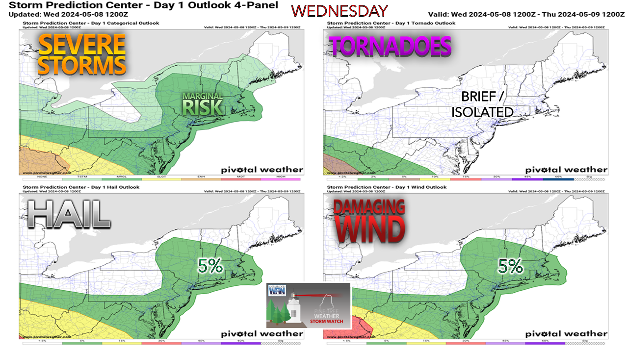 The general consensus of the Storm Prediction Center folks is the upper low to the northeast is likely to take the steam out of the warm front, and keep the greater threat for instability to the south. Forecast dew point temperatures appear hard-pressed to reach 50° over the far south. In that scenario, it keeps thunder in the forecast, but with little to no severe concerns. A slight shift of the offshore high to the east and/or a smidge of a retreat of the Labrador low may change the ballgame over far southern areas, but as of early Wednesday morning, the main focal point of severe concerns is to the southwest of the state, where they have had plenty of it in the past few days. For those in the York County region, stay aware of what the atmosphere is speaking to you. Timing through Thursday Wednesday 6 AM to Thursday Midnight - As the warm front works its way northeast, showers break out over the south and west in the morning and move into northern and eastern areas in the afternoon. The warm front eventually stalls over southern New England by afternoon. Weak disturbances riding along it have a chance to fire up another round of showers and possible thunder later in the afternoon into the evening over the south. Cloud cover is likely to dictate whether storms become a bit feisty. The adage of “sun’s out, look out” comes into play here. After sunset, the storm threat diminishes. Expect areas of fog to break out in the overnight hours.  Thursday Midnight to Friday Midnight - Northern areas have the best chance for showers on Thursday. As the weak disturbance slides into the Gulf of Maine New Brunswick, a northerly wind flow takes place. Pop-up showers are possible along with a raw breeze through the day. The weak low moves east for the Atlantic overnight into Friday.  Removing most of the convective element from the total rainfall picture shows a general ¼-½” of rainfall expected from Katahdin south. Where thunderstorms pop up on Wednesday, some areas could see upwards of an inch, perhaps a bit more. It’s a potluck situation for the south. Weekend preview Friday 2 AM to Sunday 8 PM - I mentioned earlier in the week that I did not trust model ideas as far as how the weekend was going to play out. At first, they were rather juicy in output but underestimated the trough digging in from the north. While it won’t be a weekend to write home about with cloud cover, cool temperatures, and isolated showers, it doesn't appear to be a washout. I do expect the pattern to be rather unsettled into the foreseeable future as ridging over the Pacific Northwest funnels troughs and upper lows across the region as a strong Atlantic ridge holds court in a rather blocky situation. I appreciate you! Always have MULTIPLE ways to receive weather alerts.
Stay updated, stay on alert, and stay safe! - Mike |

Mike Haggett
|


