
Wind Advisory for the mountains and north Tuesday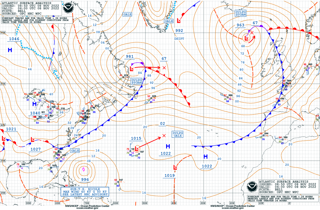 Looking at this surface map from the Ocean Prediction Center shows a very turbulent Atlantic, with one major storm affecting the British Isles with another gaining intensity off Newfoundland and Labrador. It is that storm that is causing the wind as strong high pressure over central Canada and the Great Lakes works to muscle its way into the northeast. While that battle for atmospheric supremacy is going on, there is Nicole south of Bermuda which will deliver impacts to the eastern seaboard Wednesday through Saturday. 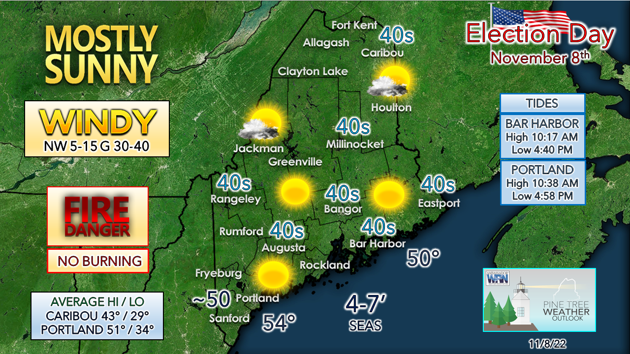 After the exceptional warmth over the past few days, a gusty wind will bring a slap in the face of reality for this time of year with wind chills in the 30s and 40s. Fire danger is likely to be high for the day with the stiff breeze, falling dew points and fallen tree debris. It's a FLYING TRASH CAN DAY for the towns with curbside refuse pick up. The ocean will be a bit choppy and make sure your hat is tied on if you go for that sunset stroll along the beach. The wind will drop by Tuesday evening. Wednesday morning brings teens and 20s for lows, the coldest of the season thus far. Ah, November! The set up for a windswept soaker for late week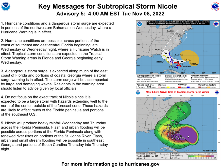 The National Hurricane Center is monitoring Nicole as the storm moves west towards the Florida peninsula Wednesday and Thursday. The storm is captured by a long wave frontal boundary and dragged up the coast, bringing impacts to Maine Friday night into Saturday. 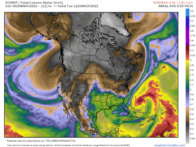 Tuesday 7 AM to Sunday 7 AM - A look here at precipitable water values which indicates how much moisture is predicted in the air column. The tropical moisture associated with Nicole is easily spotted offshore of the southeast. A ridge builds over the Midwest which moves eastward Wednesday into Thursday, which drives temperatures for Maine back above normal. A deep trough ejects southward from western Canada and sets up the long wave front which captures Nicole and brings a quick hit of heavy rain and wind to the region. 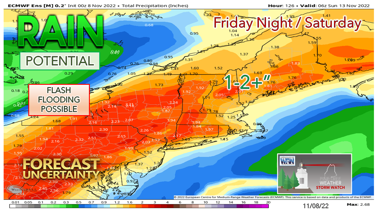 While there is a consensus with model ideas that the storm is a certainty, there are discrepancies within ensembles as to when Nicole phases with the frontal boundary and where that takes place. It should be noted that operational ideas indicate a 2-4" rainfall possibility. I like the conservative idea of the ensemble mean of the European idea for now and will monitor as details iron out. Since the region has had very little rain over the past couple of weeks, the deluge that may accompany this storm certainly sets up a flash flooding threat, along with urban street flooding from clogged storm drains, hydroplane potential on the faster roadways, along with reduced visibility in torrential downpours. 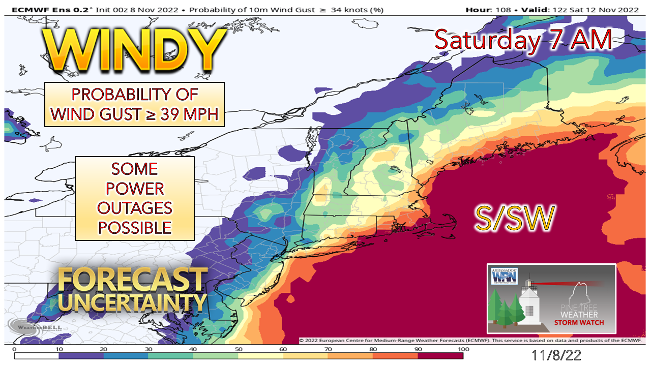 Then there is the potential for wind. This is a good signal that there is potential for at least a wind advisory for the coast, and power outages are a real possibility. Make sure your storm supplies are stocked and have batteries charged for phones and tablets.  Temperature outlook through Sunday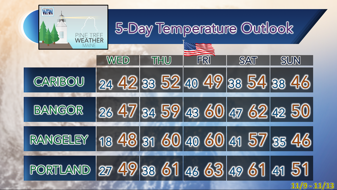 Please support Pine Tree Weather for 2023 NOTE: The forecast information depicted on this platform is for general information purposes only for the public and is not designed or intended for commercial use. For those seeking pinpoint weather information for business operations, you should use a private sector source. For information about where to find commercial forecasters to assist your business, please message me and I will be happy to help you |

Mike Haggett
|


