
It's still winter Whether you love winter or have an intense dislike for it, the fact is we have six more days until the start of meteorological spring. Looking at long range ideas, it appears that winter is going to begin to lose its grasp as we head into mid-March. For now, this coming week and the first full week in March appear wintry, either with temperature or precipitation type. The mess that will be Sunday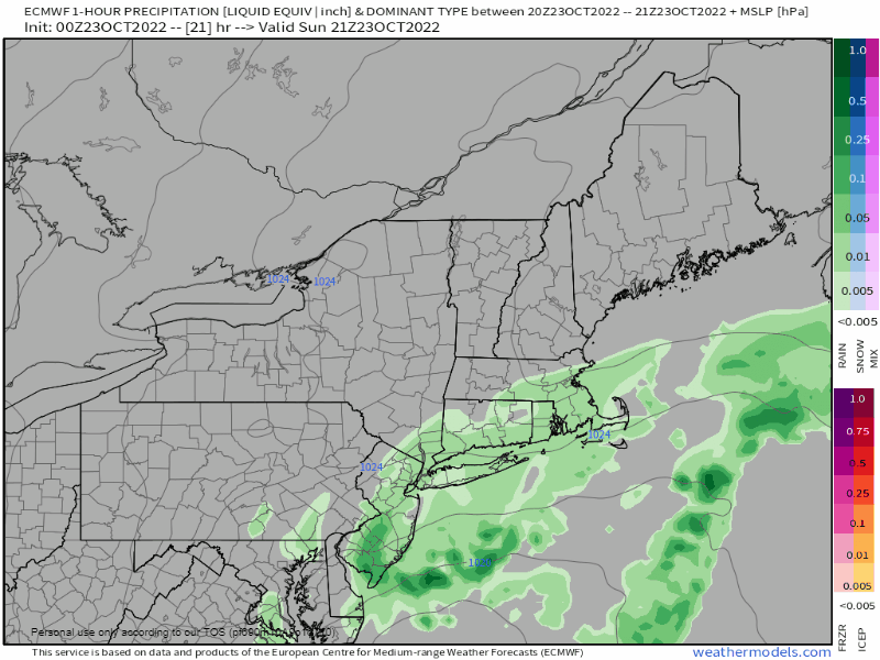 There will be a bit of fine tuning as far as timing is concerned, but for now it appears that precipitation starts in western and southern areas around daylight. This will spread eastward during the morning, and covers northern and eastern areas by early afternoon. Steady precipitation ends over southern areas by early Sunday evening, early Monday morning for eastern zones. Snow showers and flurries may effect all but far southern areas during the day on Monday, ending Monday evening. 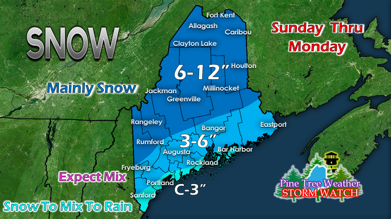 First call on snow amounts indicates yet another solid snow event for the western mountains into northern regions. Central areas can expect a mix of snow, sleet and freezing rain. The shorelines of the southwest coast, MidCoast, Penobscot Bay over the Mount Desert Island see snow change to light ice and then rain. Coastal Washington County will see some mix and rain also, but not until after 3-6" of snow makes landfall. The western mountains may be dealing with some sleet, which may knock down snow totals a bit. That said, this forecast also includes the additional snow shower activity Sunday night into Monday. I am confident that a 6"+ snow event is very possible by the time this ends Monday evening. 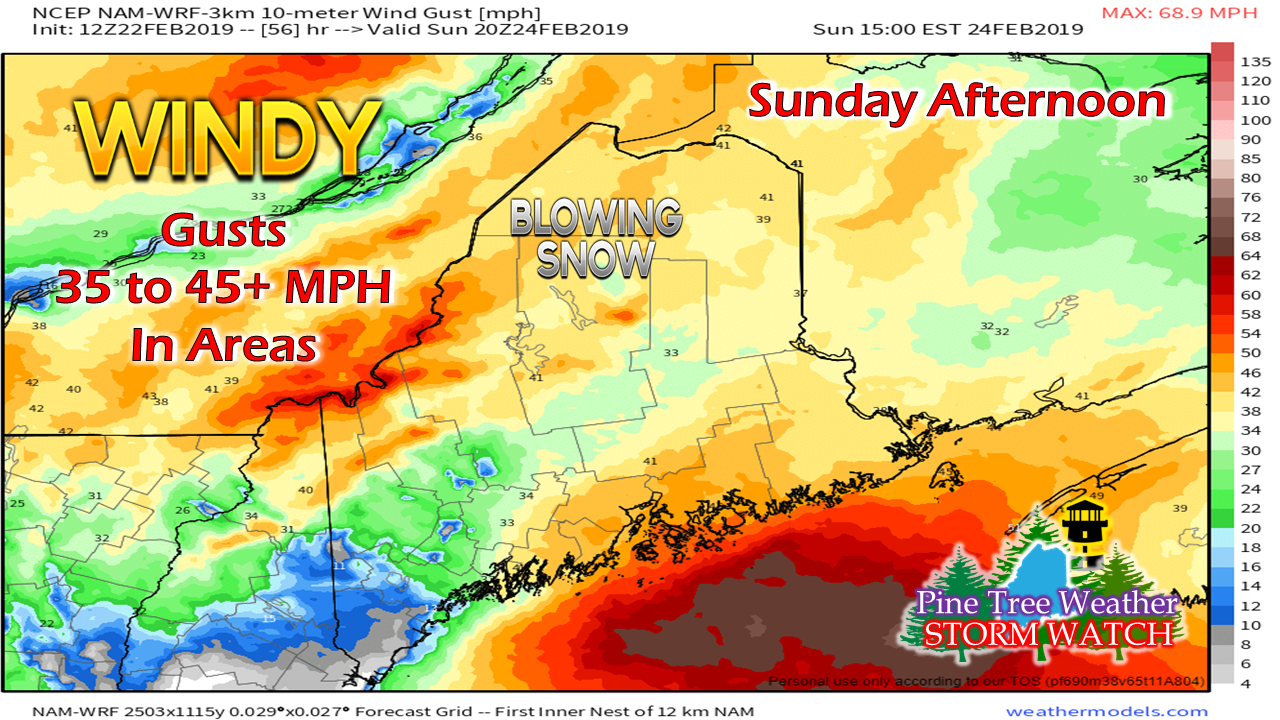 As the storm passes through the region, wind will be on the increase. The north and mountains will deal with blowing and drifting snow. The wind could be gusty enough to cause some spotty power outages in areas Sunday afternoon into Sunday night. 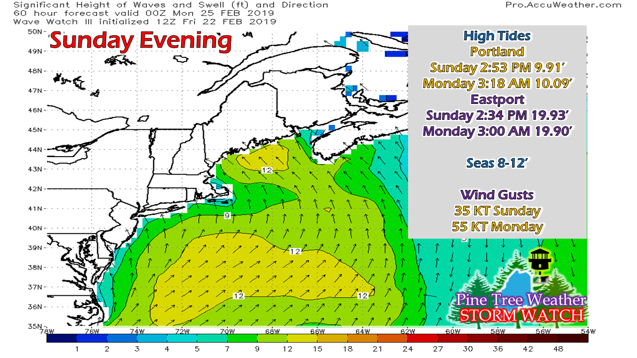 With the high tide level dropping from the recent full moon, I don't expect any major issues for our coastline. There may be some splash over in low lying areas Sunday afternoon. The wind is really going to crank on Monday. For my followers on the islands, you'll want to keep tabs on the status of ferry service both Sunday and Monday, in case of any cancellations. Monday wind looks stiff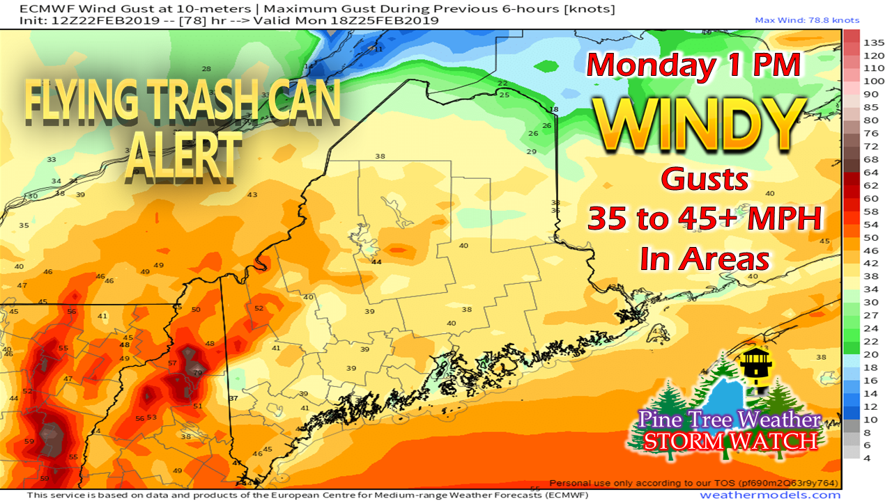 The storm slows as it approaches Newfoundland and intensifies Sunday night into Monday. As it bombs out, our region will be dealing with the wind from it. With the fresh powder in the mountains and north along with additional snow shower activity, blowing and drifting snow may cause whiteout conditions and hazardous driving through the day on Monday before settling down a bit Monday night into Tuesday. The chill returns through midweek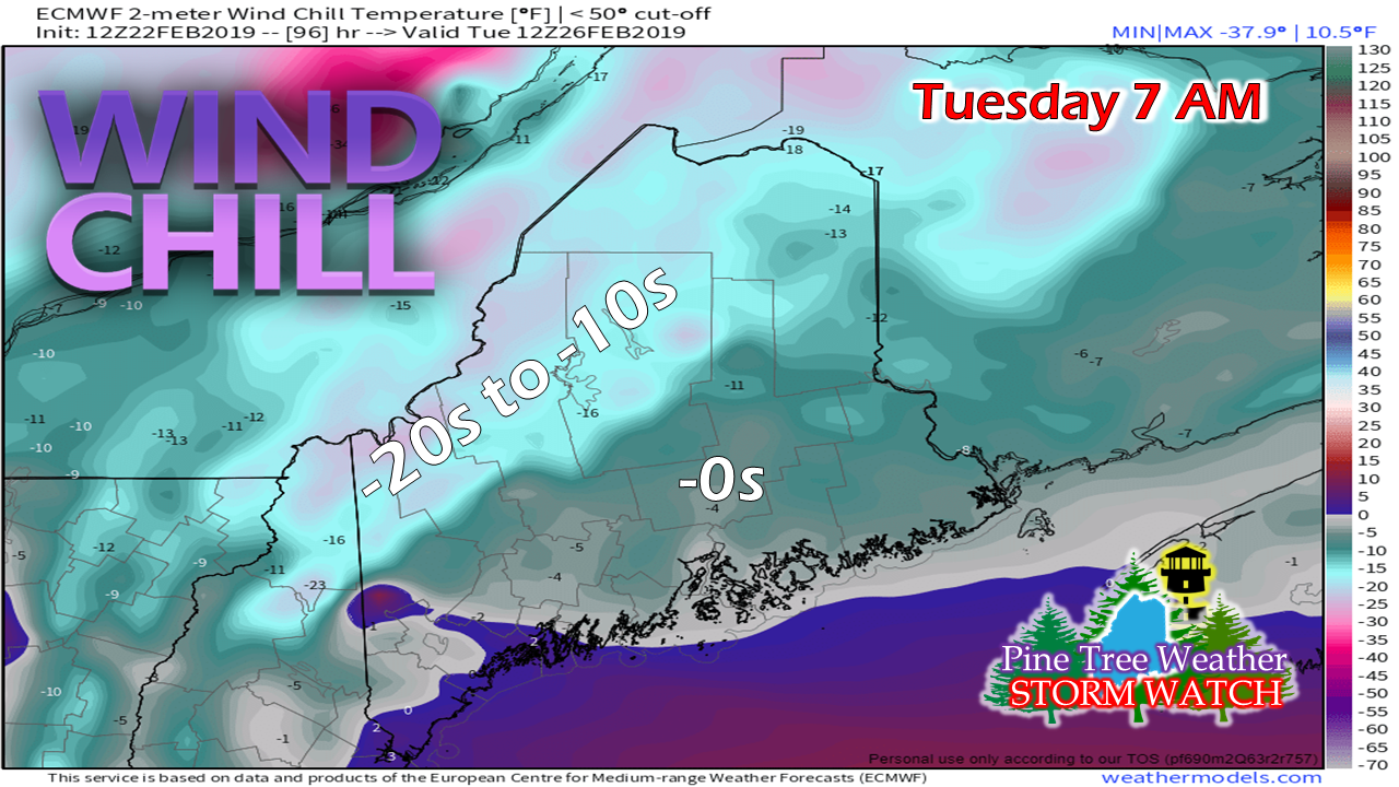 With the storm lingering around to the northeast, that will help drag down arctic air from Canada. Tuesday and Wednesday appear to be breezy ones as strong high pressure to the west battles with the departing storm. Wind gusts in the 15-25 mph range along with wind chill will be the main weather story through the middle part of the week, settling down on Thursday. Outlook through Wednesday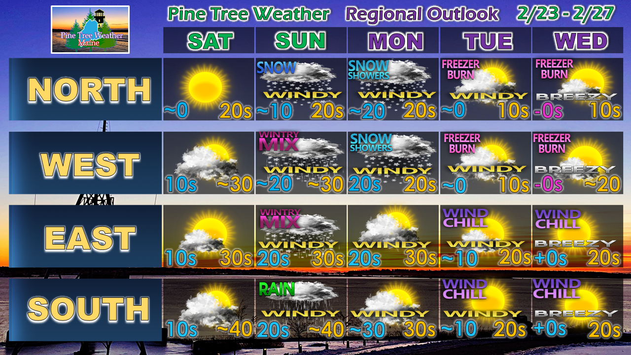 After the snow showers shut off on Monday, the region appears storm free through the remainder of the week. Guidance is toying with the idea of a coastal storm next weekend, but confidence on any potential impacts are extremely low at this point.
► ► For the latest official forecasts, bulletins and advisories, please check in with the National Weather Service in Gray for western and southern areas, or Caribou for northern and eastern parts of Maine. ► ► Your financial donations are much appreciated to keep this site funded and for further development. I am going through a busy time right now. Keep watch on my Twitter feed and Facebook in case this page is silent. I sincerely appreciate your support not only financially, but also in sharing my efforts with others. Always stay weather aware! - Mike |

Mike Haggett
|


