Pine Tree Weather
  • DISCUSSIONS
  • DONATE
  • WEATHER WALL
  • MAPS
  • RAIN OUTLOOK
  • SEVERE
  • MARINE
  • CPC OUTLOOK
  • Kennebunk
  • MY BIO
  • PTW IN MEDIA
  • OBSERVING WEATHER
  • INTERNSHIPS
  • INTERN ALUMNI
  • DISCUSSIONS
  • DONATE
  • WEATHER WALL
  • MAPS
  • RAIN OUTLOOK
  • SEVERE
  • MARINE
  • CPC OUTLOOK
  • Kennebunk
  • MY BIO
  • PTW IN MEDIA
  • OBSERVING WEATHER
  • INTERNSHIPS
  • INTERN ALUMNI

Winter weather advisory for northern areas

2/24/2021

Comments


Status Update

I've got 65 days left until my final semester is over, and school is very intense right now. My mother is in hospice care, as I mentioned here previously. My day job is also demanding quite a bit of my time as the shipping lanes are a disaster from weather impacts, storms and pandemic. I feel like I am playing Whack-A-Mole right now. This is affecting what I do here.  I know this will all pass, and it will all work itself out. I have to focus on priorities, and one of them is rest, so I can deal with the full load in front of me.

With all of this in mind, my updates will be short, sweet and to the point starting today, until life settles down. My posts may lack some specifics, but potential impacts will be well noted. My posting may be infrequent. When I post, it will be because something is going on that could impact some part or all of the state. I try hard not to waste your time or mine with the information I provide. 

I appreciate your patience, loyalty and understanding. 

Some snow for the mountains and north

Picture
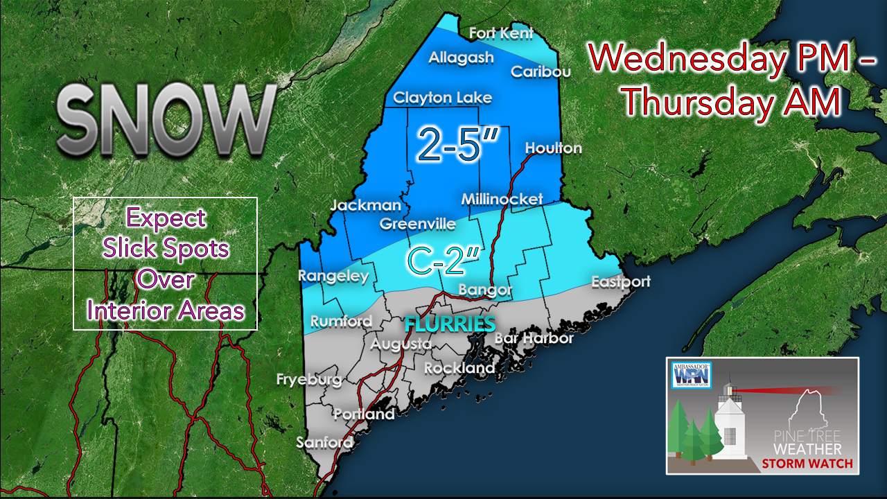
Most of the western ski hills and the north country get a fresh charge of snow Wednesday night into early Thursday. The higher peaks could get 5-8", with 2-5" the general idea for most of the region. Bangor could see a coating to an inch.
Picture
This forecast loop of the NAM3 model from 4 PM Wednesday to noon Thursday shows snow entering into western areas around 6-7 PM and overspreading the north by 10-11 PM. Snow could fall moderate to heavy at times. Snow ends from west to east by around 7-8 AM, but snow showers may persist in the mountains through Thursday afternoon. 

For those travelling in the area, expect slick conditions through the Thursday morning commute. 

Weekend outlook still up in the air

Picture
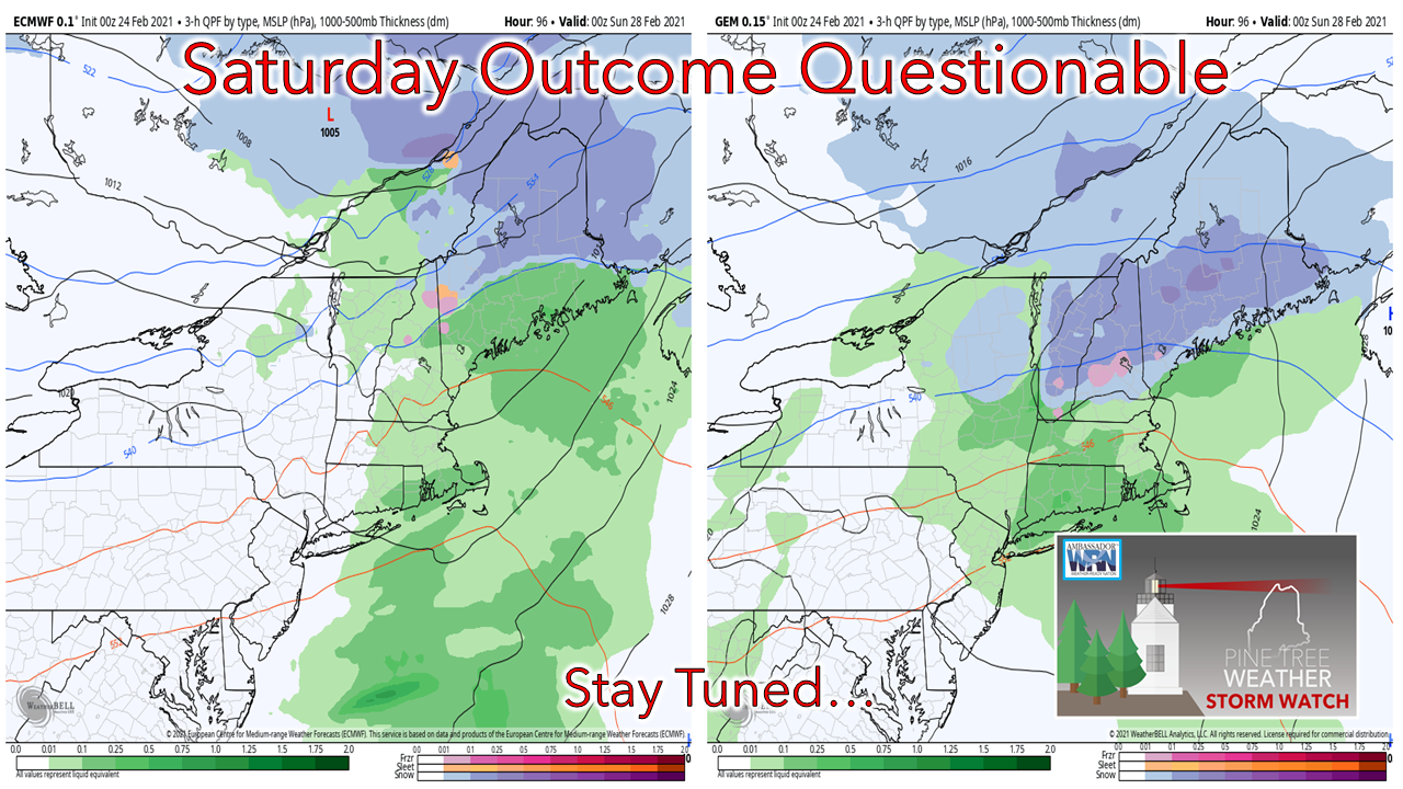
 Another quick hitting storm works into the region on Saturday. A rough idea on timing indicates precipitation starting in the mid to late morning over western and southern areas, and overspreading the north and east by mid to late afternoon. Precipitation ends from west to east by the wee hours of Sunday morning. 

Who gets what for snow or potential for ice & sleet is still to be determined. The shorelines can expect this to be a mainly rain event as the southerly flow over the ocean keeps precipitation liquid there. There is chance that all areas see flakes to start off. Northern areas appear to stay all snow. Western, interior eastern and southern areas are in a toss up zone, which could feature all four types of precipitation. 

A rough idea on snowfall is 2-5", and it could come quick in areas. Fine tuning will come on this. Stay tuned. 

​Be prepared to receive alerts and stay updated!

Picture
​​​​BE PREPARED WITH A NOAA Weather Radio.

​For $20-$40, it could provide important information to you when you need it. The weather bands are standard on most public safety scanners, and newer scanner models. Weather radios can be programmed for auto alert.  Click here for more information.

​► ► For the latest official forecasts, bulletins and advisories, please check in with the National Weather Service in Gray for western and southern areas, or Caribou for northern and eastern parts of Maine
Picture

For more information in between posts, please follow Pine Tree Weather on Facebook and Twitter. 

​Thank you for supporting this community based weather information source which operates by reader supported financial contributions. 

Stay updated, stay on alert, and stay safe!

Thank you as always for your support! 

​- Mike
Comments
    Picture

    Mike Haggett
    Kennebunk, ME

    Weather-Ready Nation
    Ambassador

    Certified Weather
    Forecaster
    Penn State '21

    American Meteorological Society

    National Weather Association
    ​
    ​SKYWARN-CWOP

    Matthew 19:26


    DONATE

    Picture
    Picture
    Picture
    Picture
    Picture

    Picture

    Picture

    Picture

    Picture

    Picture

    Picture

    Picture

    Picture

    Picture

    Picture

    Picture

    Picture


    Archives

    April 2025
    March 2025
    February 2025
    January 2025
    December 2024
    November 2024
    October 2024
    September 2024
    August 2024
    July 2024
    June 2024
    May 2024
    April 2024
    March 2024
    February 2024
    January 2024
    December 2023
    November 2023
    October 2023
    September 2023
    August 2023
    July 2023
    June 2023
    May 2023
    April 2023
    March 2023
    February 2023
    January 2023
    December 2022
    November 2022
    October 2022
    September 2022
    August 2022
    July 2022
    June 2022
    May 2022
    April 2022
    March 2022
    February 2022
    January 2022
    December 2021
    November 2021
    October 2021
    September 2021
    August 2021
    July 2021
    June 2021
    May 2021
    April 2021
    March 2021
    February 2021
    January 2021
    December 2020
    November 2020
    October 2020
    September 2020
    August 2020
    July 2020
    June 2020
    May 2020
    April 2020
    March 2020
    February 2020
    January 2020
    December 2019
    November 2019
    October 2019
    September 2019
    August 2019
    July 2019
    June 2019
    May 2019
    April 2019
    March 2019
    February 2019
    January 2019
    December 2018
    November 2018
    October 2018
    September 2018
    August 2018
    July 2018
    June 2018
    May 2018
    April 2018
    March 2018
    February 2018
    January 2018
    December 2017
    November 2017
    October 2017

Proudly powered by Weebly