
|
Heads up for new followers... a couple things to understand about this weather information operation. Hype is not my thing and has never been my thing. If you want drama, there are other outlets around for that. I work hard to shoot straight, be honest, and let you know the options. The first widespread snow for Maine is coming... but is Friday the day? Many questions to be answered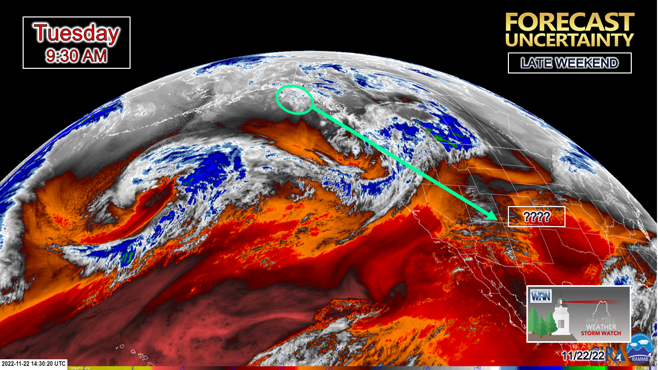 I shared this on Twitter earlier in the day Monday as I began to sift through data. Three obvious pieces here. The cold over Alaska, the upper level low over the southwest, and Zeta. All three of these ingredients are important pieces in how this comes together... or not. 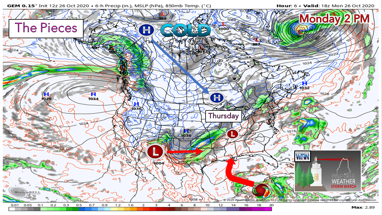 All three of these pieces need to come together by Thursday. High pressure needs to move fairly quickly from northern Alaska and be in central Ontario. This will supply the cold, and assist to navigate the storm. The upper low over the southwest needs to swing to the central part of the Midwest, which supplies the energy. Zeta will provide moisture for the system. It will have to survive the Yucatan Peninsula, then move along at a decent pace to meet up with the energy from the upper low and form a storm by Thursday morning. We're dealing with cold air, which is more dense and moves slow. We're also dealing with an upper level low located in the southwest, which has been a blind spot for the European model for years that it can't seem to solve right. Then we have Zeta, which since it is tropical in nature, which has its hurdles to deal with.  Despite all the snowfall maps that get tossed around on social media, the ones that matter at this point are the ensemble percentage ideas, given the storm potential is still four days out. It makes a difference when you cut through the model foolishness and get under the hood with ensembles. 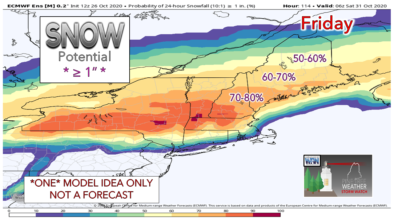 This is a "Probability of 24-hour Snowfall at 10:1 ratio (snow to water) ≥ (greater than or equal to) 1 INCH." I am stressing INCH here to make a point. This ensemble idea by the European thinks there is LESS THAN a 100% chance of ONE INCH OR MORE of snow. That doesn't give me the fuzzies to think something big is going to happen here. I need to see deep red which indicates the model is thinking it's a virtual lock for ONE INCH of snow. We're not there yet. 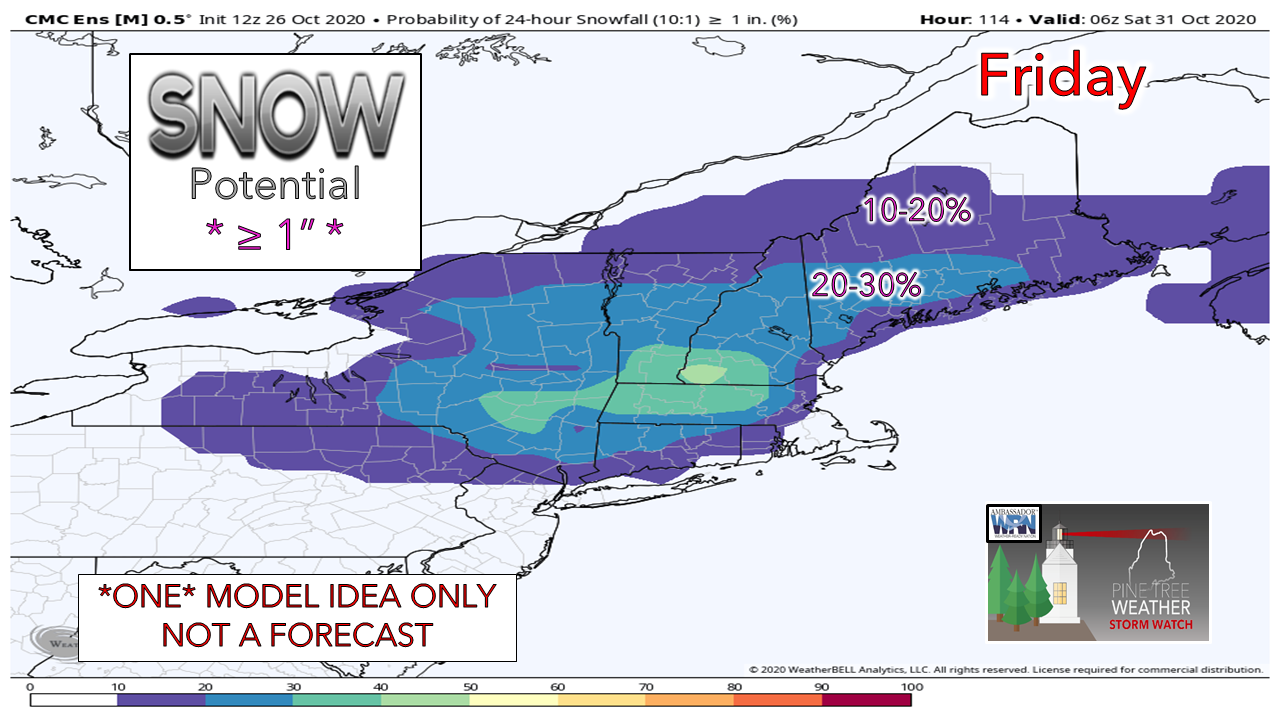 The Canadian ensemble as of the Monday morning run was even less interested in what is going on. A 20-30% chance for "Probability of 24-hour Snowfall at 10:1 ratio (snow to water) ≥ (greater than or equal to) 1 INCH" at best. The point is there are caution flags flying all over the place with this one. The truth be known is no one model has this potential storm figured out. I know for you plow people and folks who want the snow may not like my dissection of this, but I would rather you know the facts at this point than not. This can and will likely change. Whether the chance increases or decreases, it is too early to tell. We'll see how Zeta fairs after the trip through the Yucatan, how the cold progresses, and how models figure out the upper low over the southwest. In the meantime, get your appointment booked to get your snow tires put on. Winter is coming, regardless if it happens Friday or at some other point in the near future. Stay tuned for updates. Winter SKYWARN Virtual Spotter Training in November |
| | BE PREPARED WITH A NOAA Weather Radio. For $20-$40, it could provide important information to you when you need it. The weather bands are standard on most public safety scanners, and newer scanner models. Weather radios can be programmed for auto alert. Click here for more information. |
| ► ► For the latest official forecasts, bulletins and advisories, please check in with the National Weather Service in Gray for western and southern areas, or Caribou for northern and eastern parts of Maine |  |
** FUNDING NEEDED FOR 2021 **
Thank you for supporting this community based weather information source that is funded by your financial contributions.
Stay updated, stay on alert, and stay safe!
- Mike

Mike Haggett
Kennebunk, ME
Weather-Ready Nation
Ambassador
Certified Weather
Forecaster
Penn State '21
American Meteorological Society
National Weather Association
SKYWARN-CWOP
Matthew 19:26
Please
Support
Pine Tree Weather
In 2024


Archives
July 2024
June 2024
May 2024
April 2024
March 2024
February 2024
January 2024
December 2023
November 2023
October 2023
September 2023
August 2023
July 2023
June 2023
May 2023
April 2023
March 2023
February 2023
January 2023
December 2022
November 2022
October 2022
September 2022
August 2022
July 2022
June 2022
May 2022
April 2022
March 2022
February 2022
January 2022
December 2021
November 2021
October 2021
September 2021
August 2021
July 2021
June 2021
May 2021
April 2021
March 2021
February 2021
January 2021
December 2020
November 2020
October 2020
September 2020
August 2020
July 2020
June 2020
May 2020
April 2020
March 2020
February 2020
January 2020
December 2019
November 2019
October 2019
September 2019
August 2019
July 2019
June 2019
May 2019
April 2019
March 2019
February 2019
January 2019
December 2018
November 2018
October 2018
September 2018
August 2018
July 2018
June 2018
May 2018
April 2018
March 2018
February 2018
January 2018
December 2017
November 2017
October 2017