This will be a good storm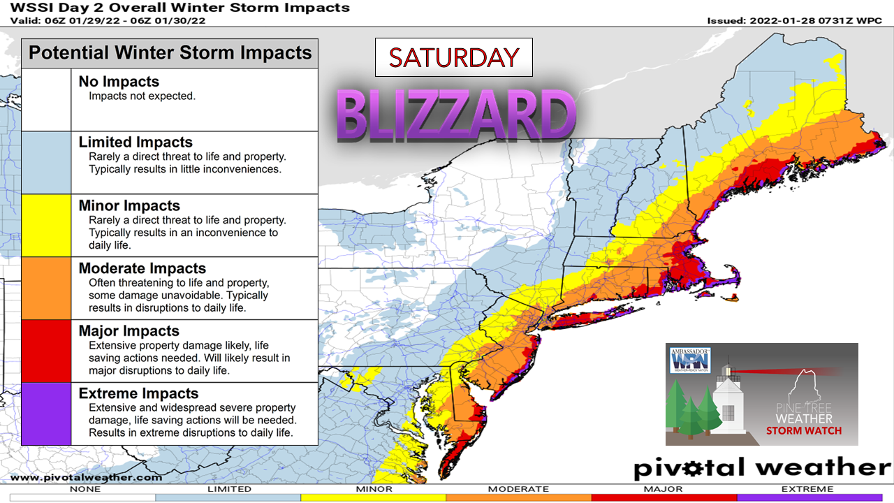 Since I don't engage in hype and work hard to be honest and matter of fact in my forecasting efforts, I want to reassure any nervous types that while the term "blizzard" may sound harsh, this particular event isn't that bad. Yes, there will be copious amounts of snow. Yes, there will be wind to blow it around. As these types of events go, this region has seen far worse on a much smaller scale. When snow does not stick to trees and there is no icing involved, it cuts down on impacts tremendously. As I have been saying for the past couple days on this website, Facebook and Twitter, get your weekend errands done Friday. Plan on hunkering down over the weekend and start Monday refreshed. Nature has a way of telling us to slow down in this hectic and crazy world. Here's a wonderful opportunity to do that. The most important thing you need to do is stay off the roads. Get to where you need to be by Friday night and stay there until Sunday afternoon. Breaking down the storm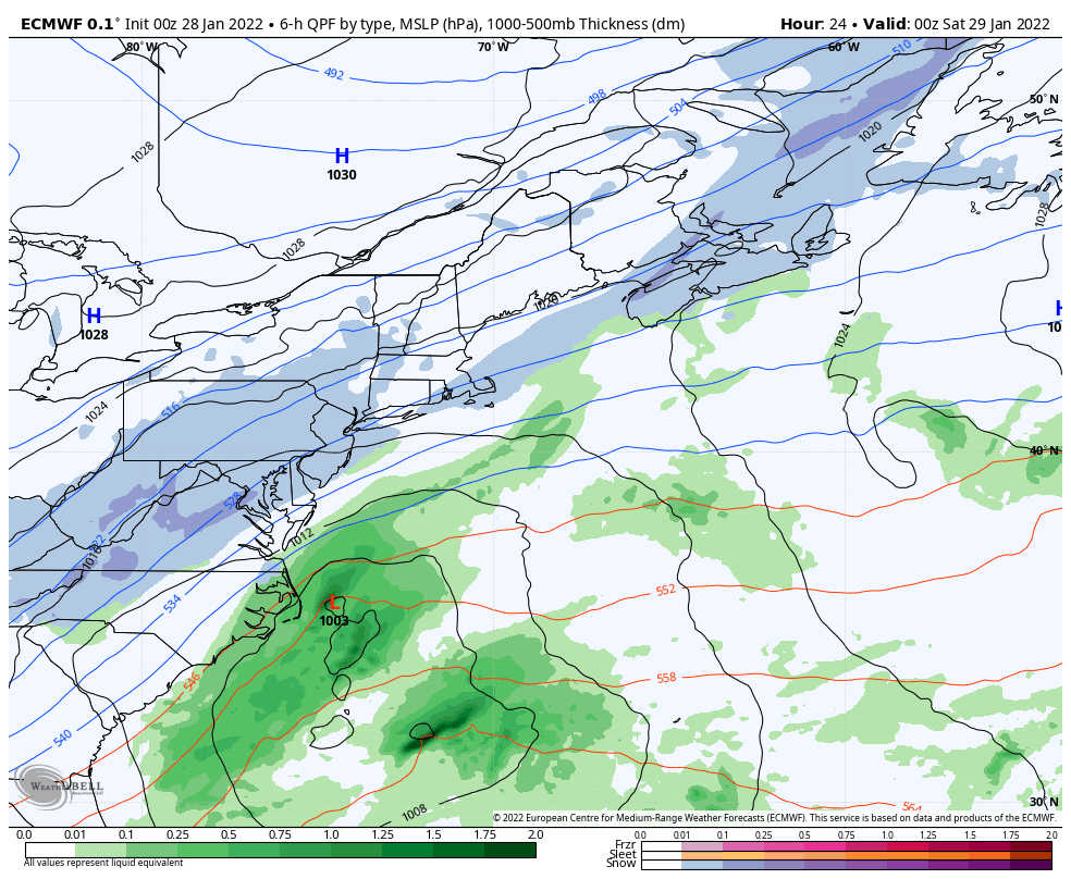 Thursday 7 PM to Sunday 7 PM - In Thursday's post I looked at the angle of the 500mb steering level and how that impacts the forecast. Now that models have fallen into much better agreement, the point that plays a factor is convection. Convection is a meteorological term for thunderstorms. In these types of synoptic events, it plays a big role in how the storm evolves and how models interpret it. I've mentioned "convective feedback" several times over the years as an issue with models over enhancing precipitation output. Therefore, snowfall charts that get spread around on social media are wrong because there is a known bias to them, and some model suites handle them worse than others. I've been picking on the European model here as of late because that is a well-documented and often discussed issue with it in meteorological circles. You can see on this model loop the darker greens offshore apart from the moisture hose that feeds into the storm. That is most likely the model picking up on convection. The over enhancement of that reading drives precipitation output higher and gives an improper idea of what is likely to happen. It also can distort storm tracks. This bias has both advantages and disadvantages for forecasters in longer term ideas pending on the situation. 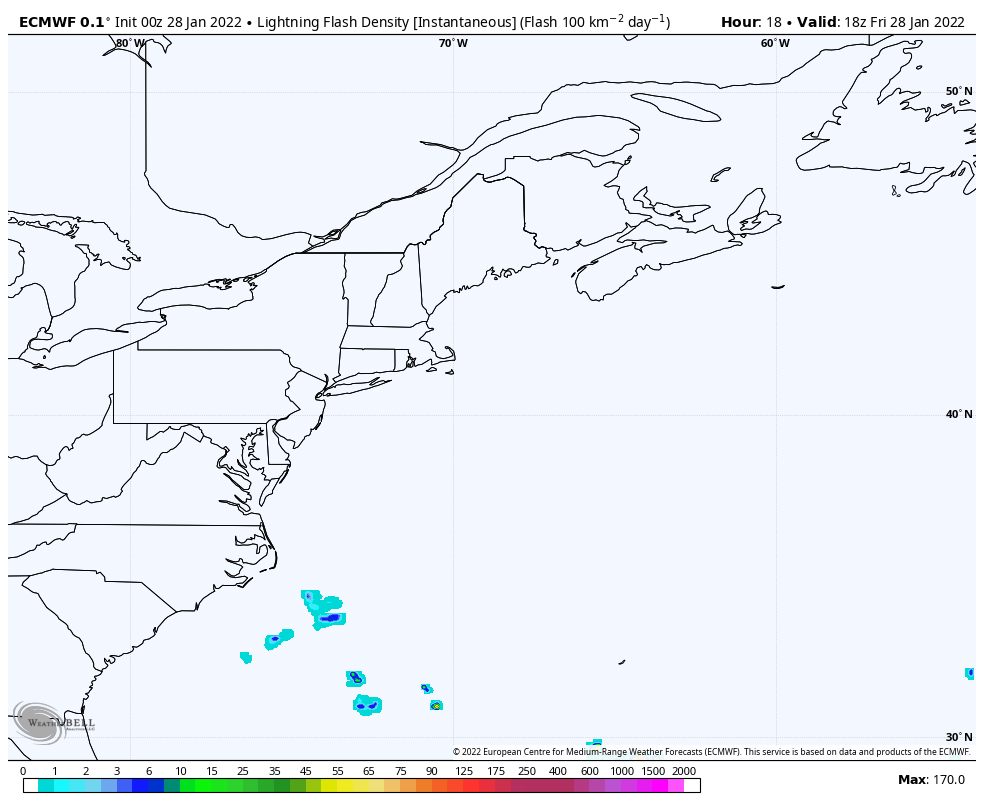 Friday 1 PM to Sunday 1 AM - The above loop here shows a lightning flash rate which indicates the convection aspect is very much involved in the dynamics of the storm. The rapid intensification of the storm helps to fuel this convection and can enhance precipitation output pending on how deep the surface low goes. 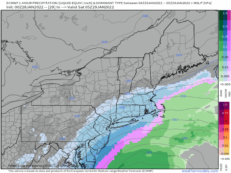 Saturday Midnight to Sunday 9 AM - Southern areas wake up to snow falling and piling up. Eastern areas get in on the game by mid-morning, and all areas are in on it by midday. The tricky part of the forecast at this point is an area of low pressure on the eastern flank that guidance has toyed with off and on over the past couple of days. Depending on that development, it may tug the storm a bit further to the east as the parent surface low and upper-level low combine and becomes vertically stacked (occlusion) over the Gulf of Maine. This is more of a concern for snowfall amounts over the fringe areas in the mountains on up into the Allagash. Snow begins to wind down from southwest to northeast Sunday morning. 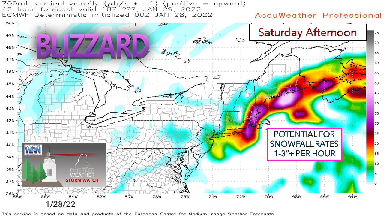 The rapid intensification and offshore convection set up deformation bands that are likely to dump several inches of snow in several hours over the coastal plain Saturday afternoon. 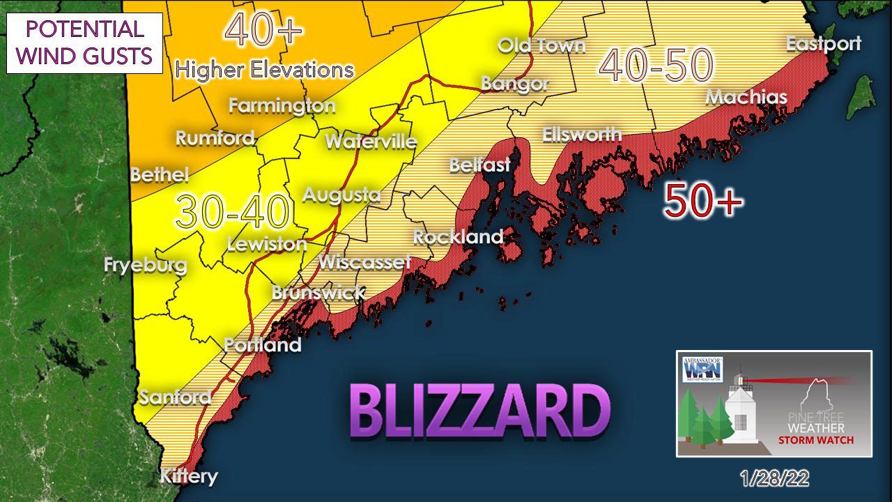 As the storm rounds the near benchmark point (40°N / 70°W) and moves into the Gulf of Maine, the wind is going to pick up. Blowing snow and drifting will make travel impossible through Saturday night. There is a risk of power outages but would be scattered due to falling tree limbs. While the storm departs on Sunday, a strong northwesterly wind continues to blow snow around through the morning and begins to settle Sunday afternoon. Blowing snow and drifting is likely to continue to be a travel hazard until Sunday night. Another layer to look at is the 700mb, which is the key snow growth level as it handles the moisture stream... 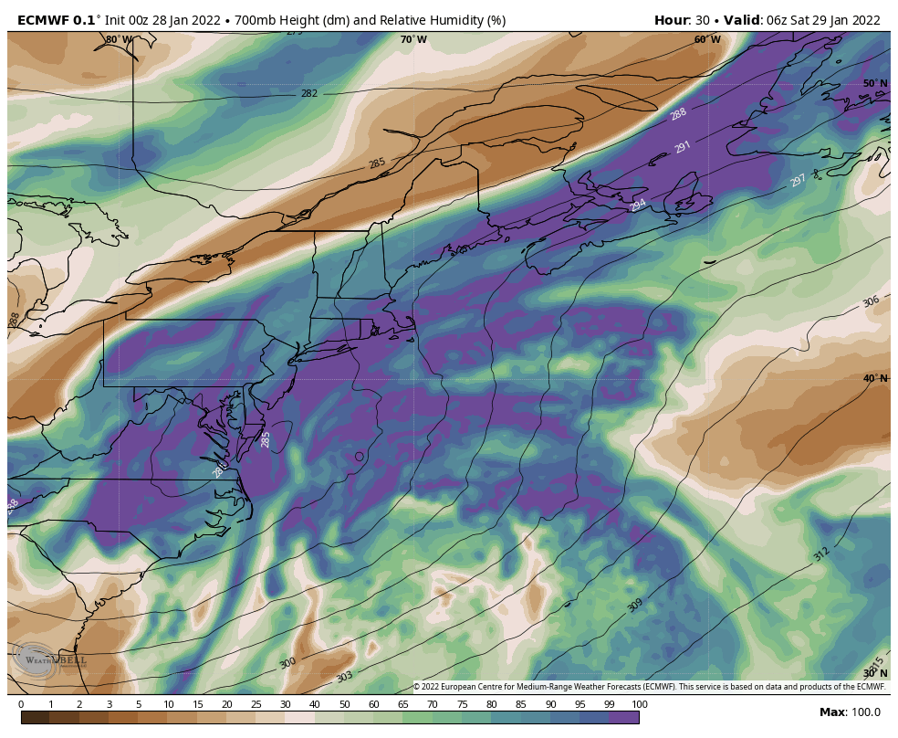 Saturday 1 AM to Sunday 7 AM - Anytime there is a rapid intensification, and the storm becomes vertically stacked, dry slotting becomes a potential threat to cut snowfall amounts. Watch the browns feed into the right flank of the storm. Once the storm vertically stacks and becomes occluded, the water hose shuts down and begins to slowly dissipate as it departs. If the stack happens early, it could drop snowfall amounts. With the amount of wind around, it may not be noticed. 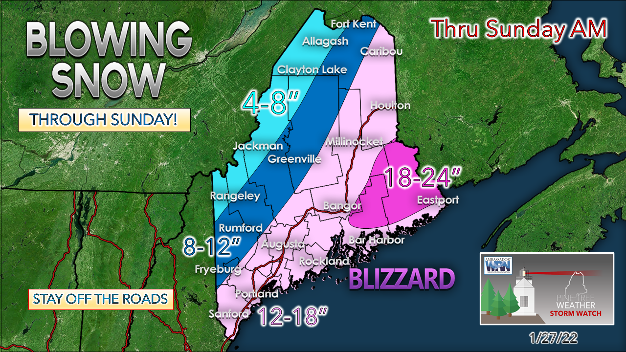 For the coastal plain, this storm won't be measured by snow on the ground, but by the feet of the drifts. DownEast shoreline areas may see a bit of a mix work in as the storm moves into the Gulf of Maine. If there is a place where snow may stick in places it would be there. Minor shoreline issues expected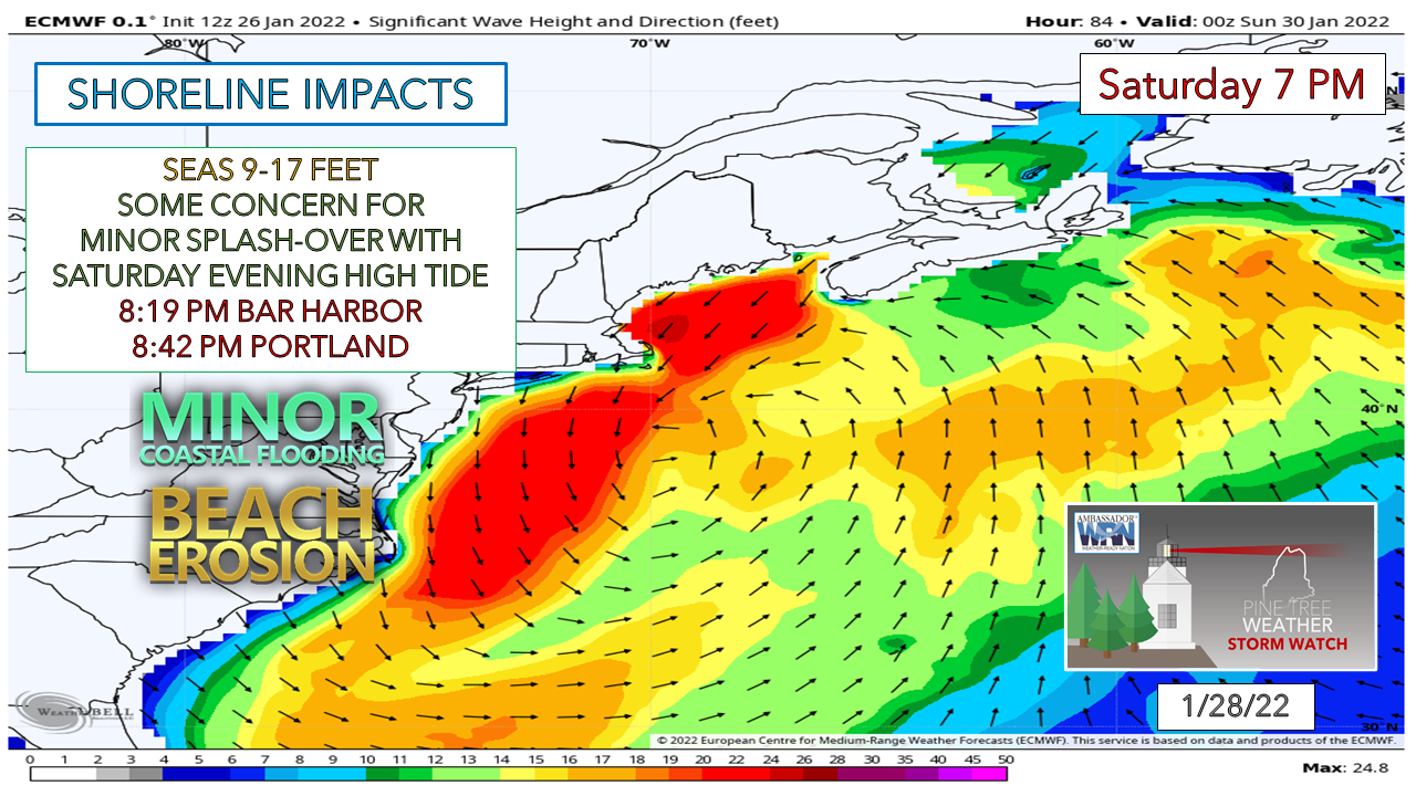 While the shorelines will deal with some abuse, the area that gets hit the worst is the eastern shores of Massachusetts and Cape Cod. An expected storm surge of 2½' is expected to move in as the storm heads into the Gulf of Maine Saturday afternoon, which coincides with low tide. Fortunately, the Saturday night high tide is the lower of the two of the day by roughly 1½' which takes the edge off. The Sunday morning high tide may feature some splash-over as well. LIVE UPDATES ON TWITTER  Be prepared to receive alerts and stay updated!
 For more information in between posts, please follow Pine Tree Weather on Facebook and Twitter. Thank you for supporting this community-based weather information source which operates by reader supported financial contributions. Thank you as always for your support! - Mike NOTE: The forecast information depicted on this platform is for general information purposes only for the public and is not designed or intended for commercial use. For those seeking pinpoint weather information for business operations should use a private sector source. For information about where to find commercial forecasters to assist your business, please message me and I will be happy to help you. |

Mike Haggett
|