
|
This is a complicated storm given the dynamics of the inside runner track. I know folks are trying to figure out how to attack clean-up for this storm, not to mention travel in it. If you missed the previous post on this from Tuesday evening as I try to break down this sloppy nightmare for most areas, you can click here to read it. Keep in mind here as you are reading along here that the HRRR short term model idea that I am presenting is just one model idea. I am using estimations based off that model. It may not be exact. This is for general information purposes only. I may ruffle a few feathers here by saying that the snowfall maps are pretty much useless south of Route 2 on over into eastern areas given the flip to rain that is going to occur. We're going to get some snow for sure, but with rain coming in, it's not about the amount of snow per se as it is the amount of slop that this storm will generate. There is also the wind and temperature pieces in this. I've created a four-way split screen to walk through this. Three-hour steps from midnight to noon Thursday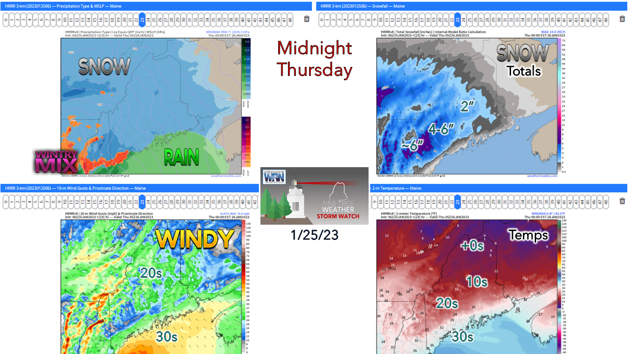 As of midnight Thursday, snowfall should have a good start over the interior with the warm front working in along the coast. The shoreline communities may pick up a couple inches of snow, but the general idea is that by midnight, it will flip to rain or be close to it. Snow will be dumping along the warm front on the cold northern side. I've seen ideas of 1-2"+ per hour, so it will make travel a dangerous task at that hour. The cold is locked in tight over the north, and a southeast wind flow is beginning to pick up. 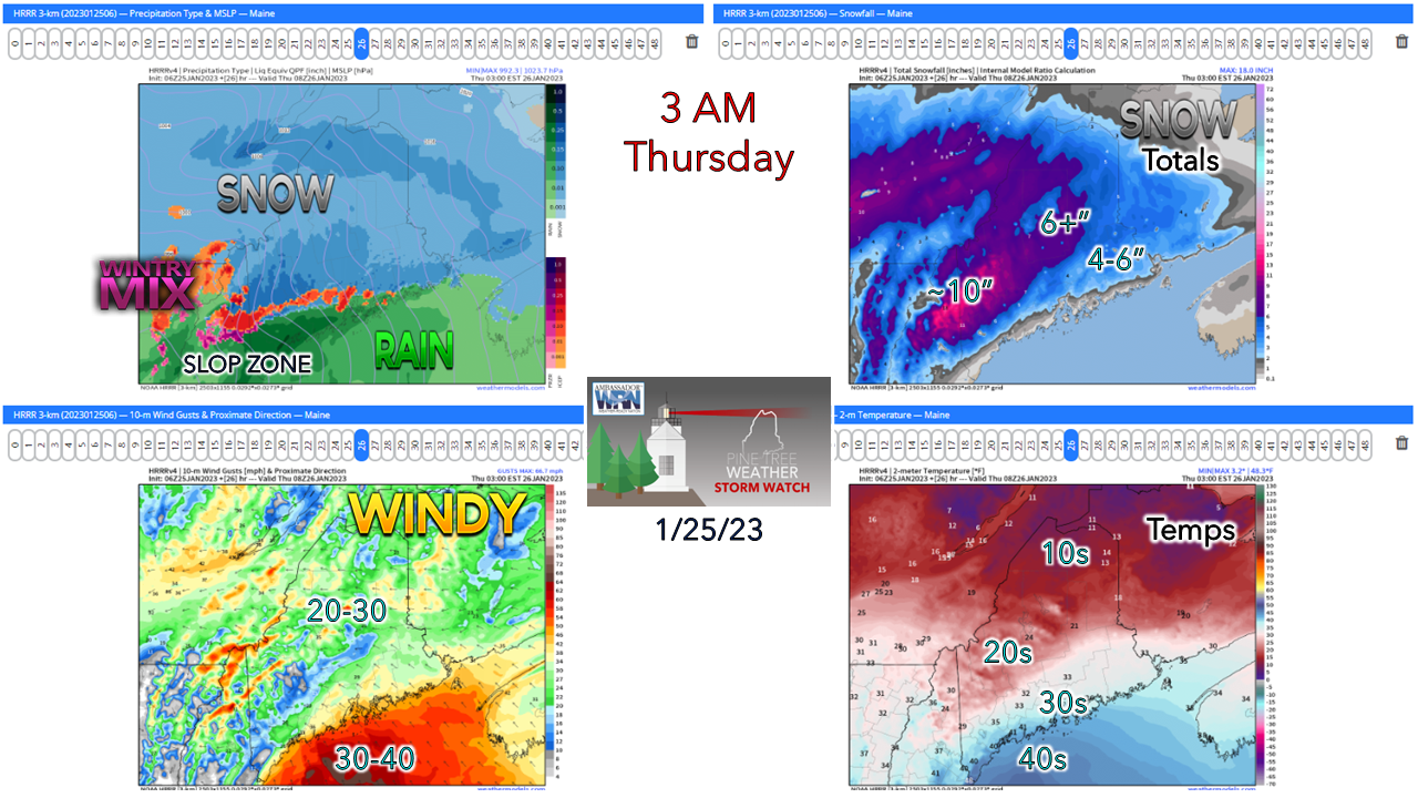 In this set I've introduced the "SLOP ZONE" as that is where any snow on the ground turns to slop as rain takes over, which at this point may be hanging along the western foothills to near Bangor. The wind begins to pick up as the storm moves into upstate New York. Where snow is sticking at this point begins to become problematic. Roads may be impassable in areas due to the rapid accumulation of snow along the front. For you early birds with the long commutes coming down from the foothills, you really need to be smart and alert with this one. Studded tires may not be enough here, and four-wheel drive may give you double the chance of getting into trouble. 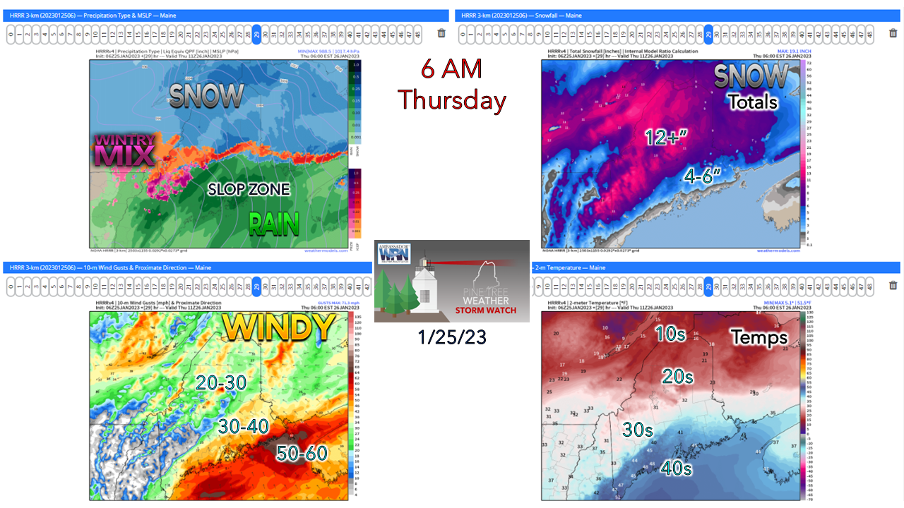 By the time daylight begins to crack is also where the slop zone expands up to Route 2 and over through central and eastern areas, which could make the morning commute a dangerous affair. The low-level jet cranks at this point, bringing the greatest chance for power outages DownEast during this window. A solid foot of snow is likely by this point over the mountains and north, and the ski hills transition to a bit of a mix. 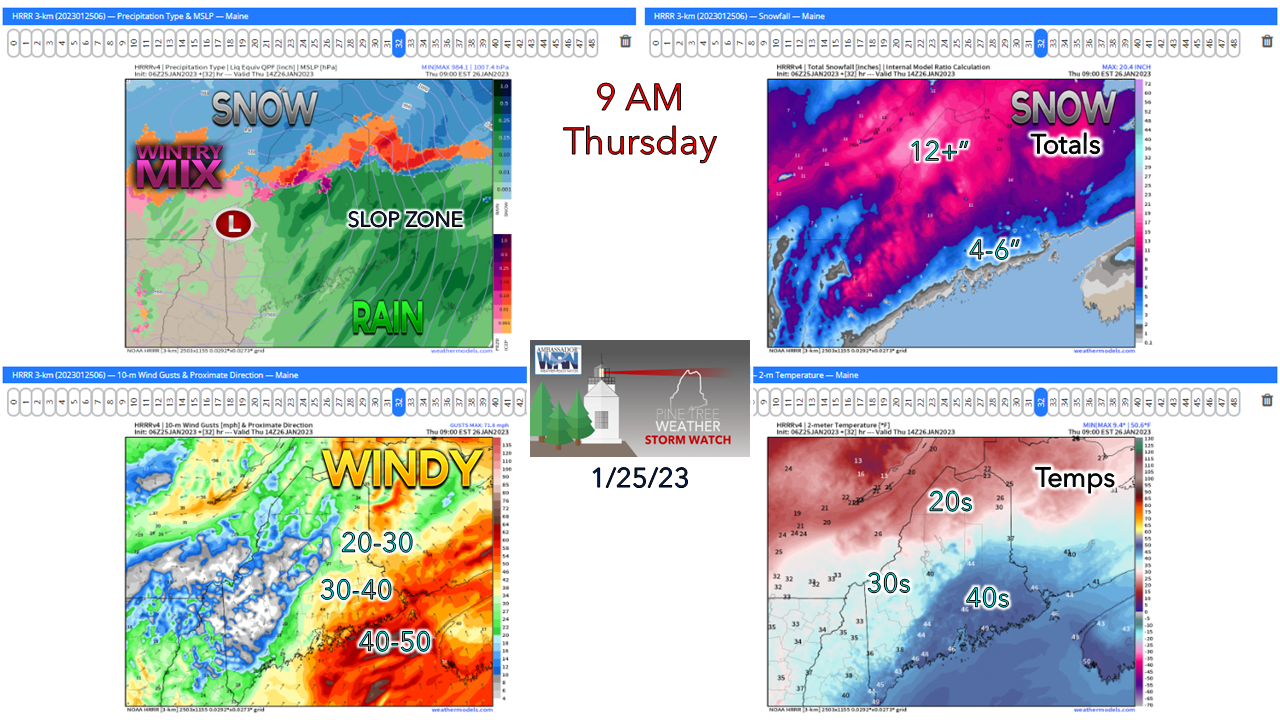 By mid-morning the low enters into the state near Rangeley. The ski hills may end with a bit of rain, but it won't impact the frozen goodness much, if at all. Northern areas up around the Allagash will be buried by this point with a bit of a mix going on. Wind over DownEast areas is slowly diminishing, but still strong. Much of the state is sitting in the warm sector at this point with only The County in the 20s for temps at this time. 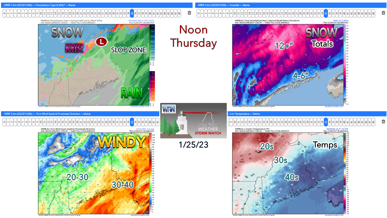 By midday, precipitation begins to taper off over the north as the slop zone moves into New Brunswick. With the storm crossing the crown of the state, winds settle over DownEast areas a bit more. A cold front approaches the region in the afternoon which brings in wind from the southwest out ahead of it which could be gusty at times through the afternoon. The mountains and north may pick up some snow showers as the front passes through in the afternoon into the evening. Southwestern areas see the sun poke through the cloud cover late morning into the afternoon which will help clean up the roads, parking lots, driveways, and sidewalks. Whatever is left for slush around Thursday night turns into cement by Friday morning. Make sure your plow gear is in good shape. Also, if you have a snow blower, you have spare cotter pins and belts in case you need to switch those out. If you have to shovel this mess, please take your time. Have your phones charged and be ready for power outages. This is my final website update on this storm. My Twitter will be active and may post on Facebook pending any changes. As always, stay in touch with the National Weather Service for the latest from them. I hope this helps!  Thank you as always for your support! You may not like the weather, but I hope you like what I do! Please hit the like button on Twitter and Facebook, and share! Financial donations to fund what I do are always appreciated! Stay updated, stay on alert, and stay safe! - Mike NOTE: The forecast information depicted on this platform is for general information purposes only for the public and is not designed or intended for commercial use. For those seeking pinpoint weather information for business operations, you should use a private sector source. For information about where to find commercial forecasters to assist your business, please message me and I will be happy to help you. |

Mike Haggett
|


