Batten down the hatches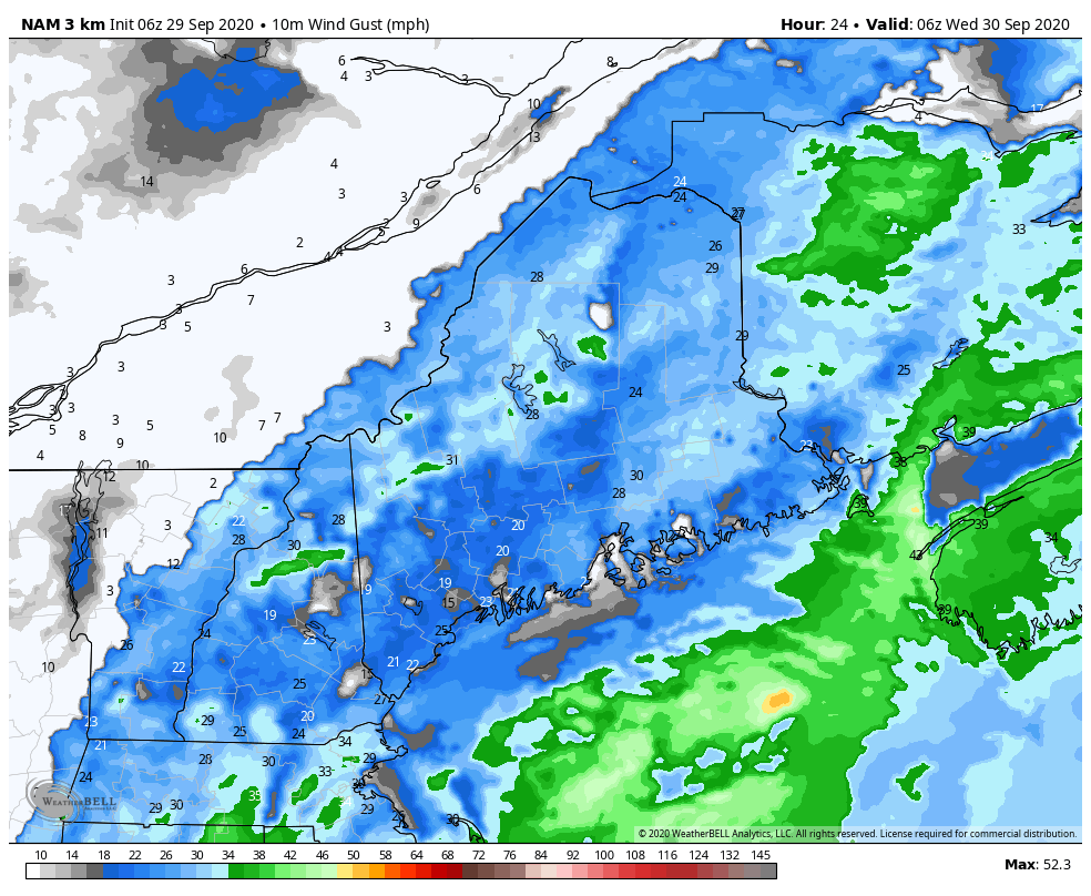 9-29-20 #MEwx TUESDAY Morning Update - Rain and wind overnight into Wednesday, POWER OUTAGE potential. For TUESDAY... DENSE FOG ADVISORY for the coast from Portland to Eastport. Expect it could be stubborn in departure, and could hang tough all day. Areas of drizzle are possible in areas of fog. It appears to be a mainly cloudy day for most, with temps in the 70s, 60s for MidCoast & DownEast areas trapped in fog. If the sun can peek through, temps may hit 80°. Dew points will remain on the sticky side through Wednesday. Overnight lows into Wednesday range from the upper 50s along the international border of Quebec to the low 60s for the coast. WEDNESDAY... A WIND ADVISORY has been posted by NWS Boston for northeastern Connecticut, eastern Massachusetts (Worcester-Lowell-Boston-Gloucester), Rhode Island, Cape Cod, Martha's Vineyard, and Nantucket from 11 PM Tuesday night to 8 PM Wednesday. A GALE WATCH has been issued for the Maine coastal waters Wednesday morning through Wednesday evening. NWS Caribou mentions that a wind advisory is likely for northern and eastern Maine, and hints at potential for a high wind warning possible for the coast. Consulting with NWS Gray this morning, they will decide today on any wind headlines. Seeing similar set ups to this in the past, MidCoast areas may see a wind advisory. How much further west and north is still to be determined. As I mentioned in the post on pinetreeweather.com Monday evening, expect a FLYING TRASH CAN ALERT out of this at the very least. Secure any objects around the house that could go airborne. If you have garbage collection service on Wednesday, please do what you can to keep the lids on the cans prior to pick up. With this wind comes the risk of POWER OUTAGES. Areas near the shorelines, higher elevations could see wind gusts in the 40-50+ mph range. For most areas, 30-40 mph gusts are possible. TIMING OF THE WIND shows it on the increase Wednesday morning. The stronger gusts work through western and southern areas by early afternoon, northern and eastern areas by evening. RAIN amounts appear in the half-inch to 2" range, highest amounts in the mountains, lesser amounts for the coast. Showers overspread the state early Wednesday, end from west to east in the afternoon, and the faucet shuts off everywhere by around 8 PM in the evening. TEMPS appear to be in the upper 60s to low 70s. After the front passes, the humidity drops. Overnight lows fall into the mid-40s north and mountains to the low 50s coast. THURSDAY appears breezy. Sun for the coast, a few clouds around for the mountains and north. High temperatures in the low 60s north to near 70° south. NEXT CHANCE FOR RAIN appears Friday night into Saturday. Have a great day, and thanks as always for your support! - Mike
For more information, please follow Pine Tree Weather on Facebook and Twitter.
** FUNDING NEEDED FOR 2021 ** Thank you for supporting this community based weather information source that is funded by your financial contributions. Stay updated, stay on alert, and stay safe! - Mike |

Mike Haggett
|