Similar day for Friday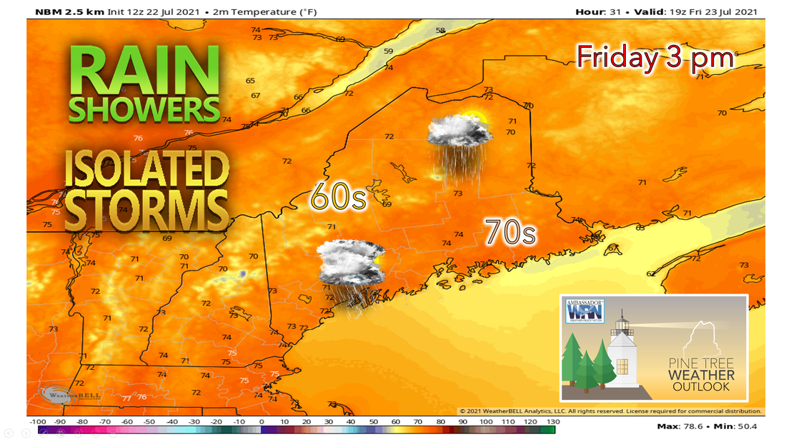 Showers and thunderstorms will begin to diminish with most ending around 9 or 10 pm tonight. Expect some partial clearing overnight which will allow for low temperatures to drop into the 50s. A few mountain zones may drop into the upper 40s. Overall expect a quiet night with periods of broken clouds, the clearing and light winds will allow for some fog to form overnight as well. Similar day on Friday as compared to Thursday’s weather as the upper-level trough remains overhead. Friday will feature another round of diurnal showers with a chance for a passing rumble of thunder as the upper low begins to move to the north and east. An offshore flow from the NNW will continue allowing for temperatures to stay right around the 70°F mark area-wide. Another round of scattered showers with isolated thunder Friday afternoon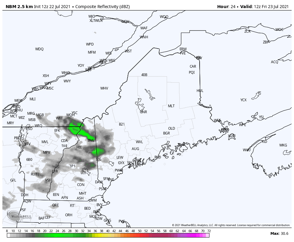 We should expect another round of widely scattered showers with thunderstorms for much of the state. The upper-level trough remains over the area allowing for scattered unsettled weather to develop across the region mainly after lunchtime as we get our daytime heating. Temperatures aloft will be colder on Friday than on Thursday allowing for more instability to be present. Showers and thunderstorms could be a little more widespread than what we saw on Thursday. While the chance for a few strong gusts remains, the atmosphere will not be as favorable to hail development. Overnight, clear skies and cooler air will allow for temperatures to drop into the 50s once again as high pressure moves in for Saturday. Fair weather for Saturday but rain returns Sunday Ridging aloft and high pressure at the surface passes over New England allowing for Saturday to be a beautiful late July day in Maine. Saturday still looks like the pick of the weekend with mostly sunny skies and highs in the mid to upper 70s for a majority of the state, with a few communities getting close to 80°F. Dewpoints will also be low making it feel very comfortable for a summer day. High pressure begins to shift offshore Saturday night followed by an approaching warm front on Sunday. 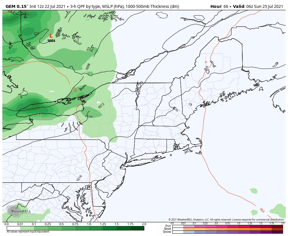 On Sunday, a warm front begins to move through the state during the morning hours, which results in more rain during the day on Sunday. High temperatures are kept back a few degrees from where they were Saturday thanks to the cloud cover and rain. Most places across the state will see dewpoints climb back into the upper 60s heading into Sunday afternoon. The humid air mass looks likely to stay around through at least the middle of next week. Temperatures during this time won't be incredibly warm, but with the higher humidity temperatures in the upper 70s and lower 80s will feel warmer over this stretch. Beginning of the next workweek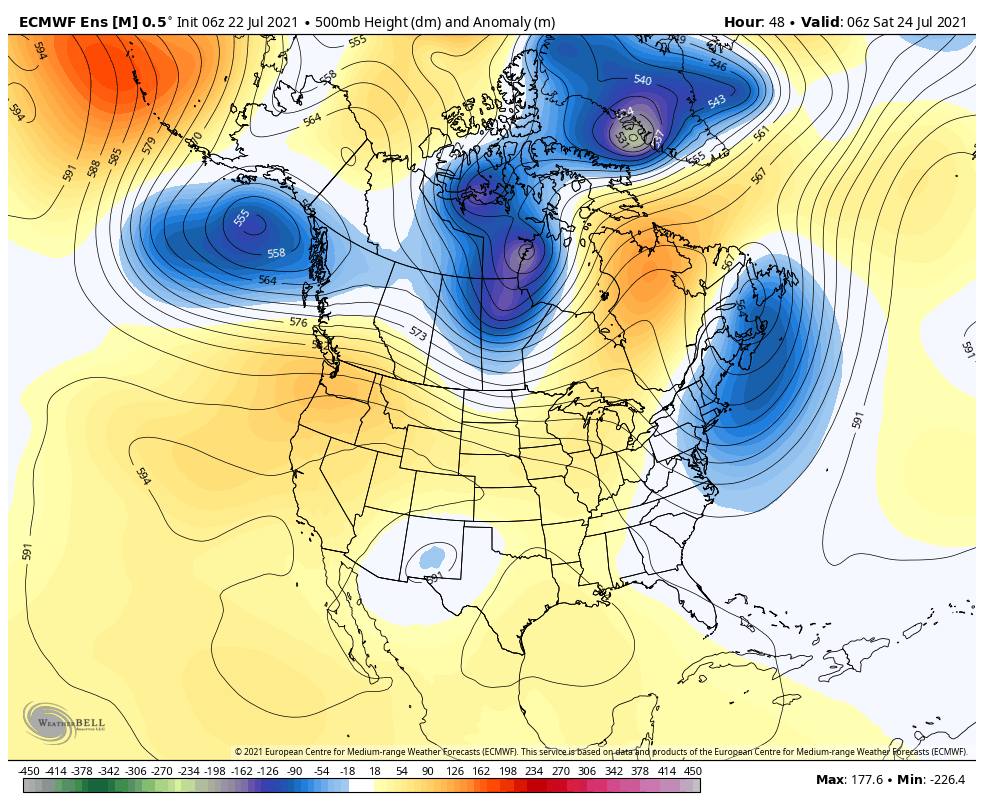 Heat will continue over the northern/central Plains into the Upper Midwest as a ridge just sits over the Western U.S. While the Plains will see ridging, the Northeast will see more troughing over the area. This will allow for temperatures to remain right around average and normal precipitation is expected as small disturbances are favored in this track. Humidity is expected to increase in our area as we begin next week. Drought monitor: the tale of two Maine'sWhile the month of July as been a soaker for the coastal plain, that has not been the case for the western mountains and the rooftop of the state where the drought continues to be a concerning issue. While the recent rain for the coast has been needed and, in some cases, appreciated by those dependent on groundwater resources, I toss the caution flag for the short term. 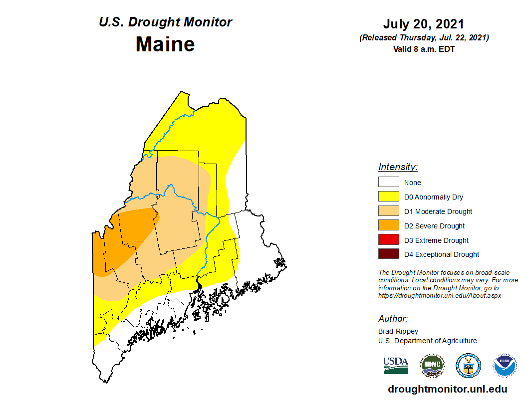 I can tell from Facebook comments that there is angst among those in the western mountains and foothills, with probable cause. While the latest Drought Monitor acknowledges the rainfall deficit, digging a bit further into the issue shows a deeper concern. 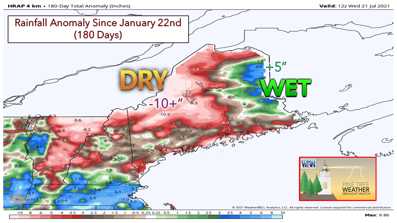 While the HRAP model idea is based heavily on rainfall estimates, it shows regions of concern highlighted on the Drought Monitor very well. Much of the state is running at a substantial deficit, even with the recent rainfall since the beginning of the year. The impact of the dry winter and spring continues to loom over the region. Looking at numbers from National Weather Service data sites across the state with decades of recording history in which to look at, the indications of drier interior areas are there: 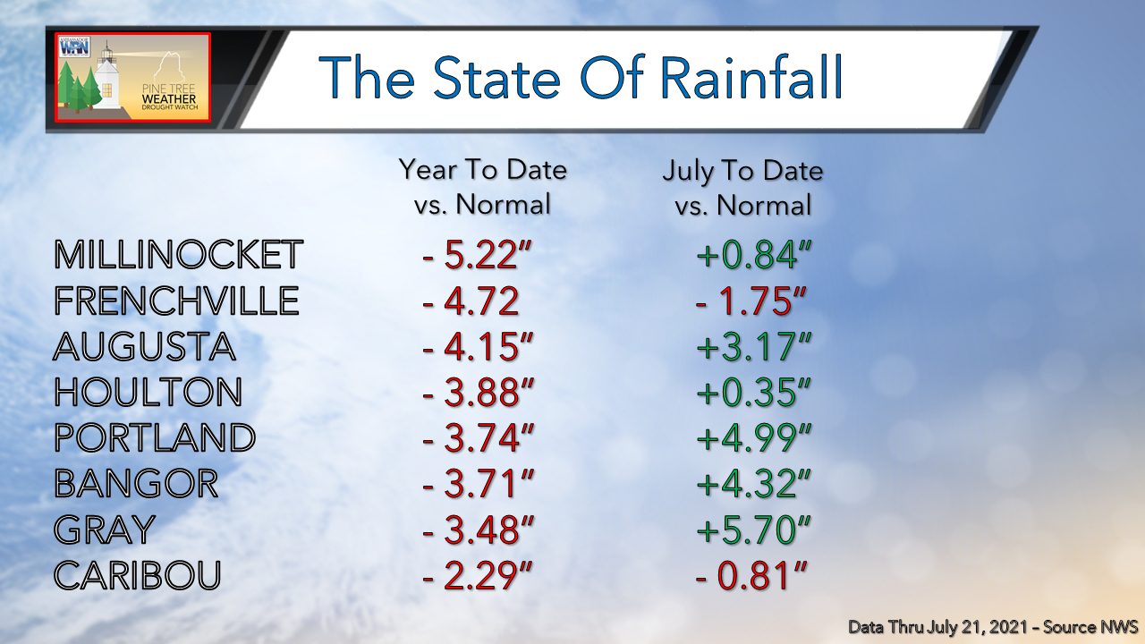 Unfortunately, there is not enough history from reporting stations in the western mountains to see hard data to indicate the true impact in that area. The deficits displayed by Augusta and Millinocket show a strong hint that interior areas could be in worse shape. The hard numbers in northern areas at Frenchville and Caribou show the current deficit that the rooftop is dealing with. A look at historical data for the July shows the haves and have nots a bit more in depth. If the month were to end today, this is what where the rainfall amounts would end up in rank in the history book with record amounts and years established:
In the far north, the opposite is in play:
There is no question the recent abundance of rainfall along the coastal plain has helped matters there. With a look at where the region was at back on July 1st, the improvement is remarkable. The deficits for Gray, Portland, Augusta, and Bangor have been cut by roughly 60% from the start of the month. For the mountains and north, most of that region continues to see a concerning lack of moisture, which is impacting agriculture and well water supply. The short-term outlook favors a bit of a damper trend for the north: 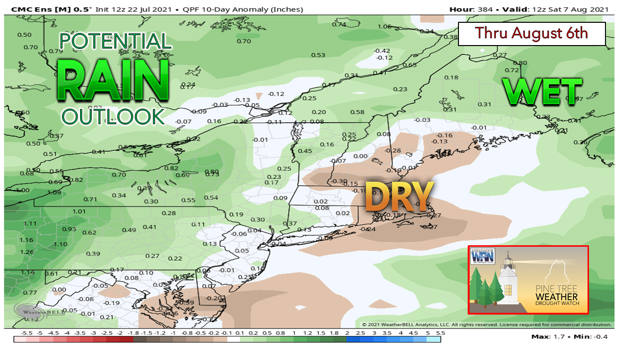 With a strong ridge forecast to develop just east of the Rockies, that idea keeps Maine on the cooler side. Like what the region sees at times in winter, clipper systems could be periodic along with an occasional upper-level low dropping in from the northwest could increase chances for rain not only for the north, but statewide as we head into the first week of August. While southern areas may appear to be dry according to this ensemble idea, confidence in that is low at this point. Are you experiencing issues caused by the drought with your well water? Please report your findings to the Maine Emergency Management Agency via their anonymous online survey. This information is vital to authorities and for scientific study to better understand the impacts in your area. More information in detail from National Weather Service Gray in their drought report. For those who have received a decent charge of water as of late, it would be wise to stay in conservation mode for now as best as possible until a wetter trend is more firmly established. - Mike Haggett Air Pollution Science 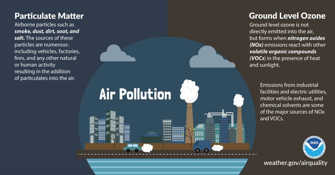 What is air pollution? The two primary culprits are: 1) Airborne particles such as smoke, dust, dirt, and soot, also called particulate matter. 2) Ground level ozone, which is formed when nitrogen oxides emissions react with other volatile organic compounds in the presence of heat and sunlight. To learn air quality safety tips, visit weather.gov/safety/airquality Temperature outlook through late JulyThe plots below show the trend of the high and low temperatures for Carrabassett, Bangor, Caribou, and Portland over the next week and a half. Temperatures through early next week will tend to average near normal with average chances of precipitation continuing. 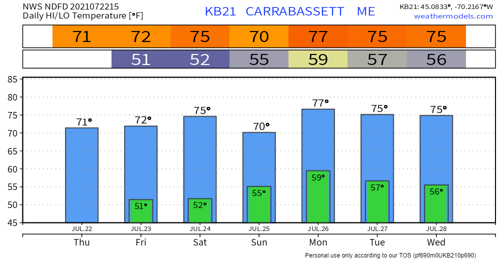 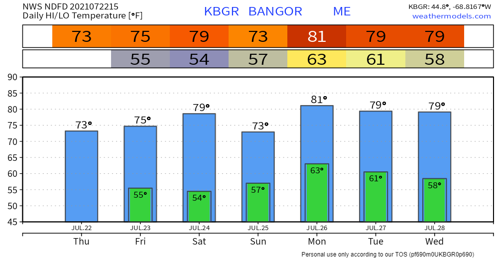 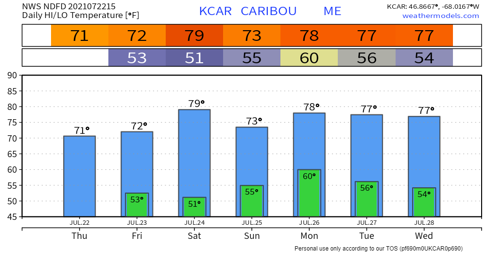 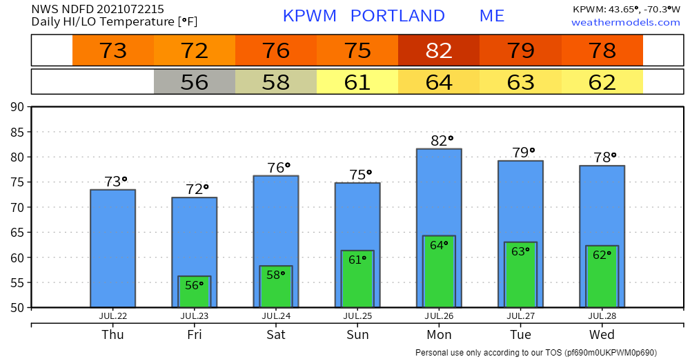 Be prepared to receive alerts and stay updated!
For more information in between posts, please follow Pine Tree Weather on Facebook and Twitter.
Thank you for supporting this community-based weather information source which operates by reader supported financial contributions. Stay updated, stay on alert, and stay safe! |

Mike Haggett
|